Monday, 14 November 2016

Cycling between cities in the Netherlands - Part Six: Hook of Holland to Breda

Last year I took a trip to the Netherlands to cycle between, and visit, various towns and cities and enjoy some Dutch cycling infrastructure. I wrote five posts about the cycle trips I took between those places: Hook of Holland to Rotterdam, Rotterdam to Gouda via Delft, Gouda to Utrecht, Utrecht to Amsterdam and Amsterdam to Hook of Holland via The Hague. This year I decided to return to the country and so will continue a series of posts on my experience of cycling between the different cities I stayed at. Just like last year every mile of this journey was cycled on my Dutch bike, the same bike I use to get around London. I wore ordinary clothes, usually shorts or T shirt (although sometimes jeans if it was a bit chilly) and did not wear a cycling helmet, just as I don't in London. My holiday just happened to take place a few days after the UK voted to leave the EU and so I was still in shock and very annoyed about the result. I decided to keep news notifications on my phone active and as I was using my phone as a sat nav it seemed that every couple of hours I was  picking my phone out of the holder to read about the various fast paced developments that were occurring back home.

I arrived in the Netherlands very early on a Sunday morning having taken the overnight ferry from Harwich. The first 11km of my journey from Hook of Holland to Maasluis was exactly the same journey as the last time I was in the country so feel free to go back and read my experience of that section from last year. It was all very familiar until I approached Maassluis train station where instead of continuing onto Rotterdam, as I'd previously done, I turned off onto a short road which lead me to another ferry portAs I had planned this ride using the Fietserbond routeplanner it gave me several options and all of these involved taking at least one ferry. I was unsure of what kind of ferry to expect and what I discovered was similar to the Woolwich Ferry, except smaller. Nearly a dozen of us were on bikes (more than were using the ferry in motor vehicles) and so we quickly set off from the port for a short ride over to the other side of the water and into the town of Rozenburg where I posted my first tweet from the country


I continued East along a bidirectional cycle track, with a decent buffer zone from the road, watching the various sized ships making their way to and from the North Sea alongside. I then travelled south through a rather bland and ugly industrial area although I saw people of all ages also getting around by bike here. The cycle track crossed over the road a couple of times and had a couple of sets of railway level crossings and was, at some points, a long distance away from the road. I thought back to all the times I had cycled through Industrial areas in the UK, often some of the worst places to cycle, mixing it up with lorries, here I enjoyed a relaxing cycle ride with a smile on my face, barely an hour into my trip knowing I had many, many more hours of this to come. 


I turned off this cycle track and climbed up and over half a dozen railway lines, through a motorway junction, and over a wide body of water, all on dedicated cycling infrastructure without having to share space with any motor vehicles at all. It was a wonderful view from the top of this bridge and I could see cycling routes I would never get to ride on, as well as ones I would be riding on about a minute later. My journey continued along a  nice path through parkland and then an elevated route, where I nosily looked down into the back gardens of houses alongside. The houses all had direct access to the path by bicycle or on foot, of course. I travelled on a road for a short distance on an old tiled cycle track, which was being used not just by cyclists, before a brief food stop at a petrol filling station and another tiled cycle track down to the Oude Mass river. I cycled along the river watching the ships alongside and families cycling past, before turning inland and onto a bike path where dogs were restricted, the first time I'd seen a sign like this. This was a narrow cycle path, and very quiet with the only sound being cows munching on grass close by. I soon returned to a wider path, sharing with dogs and joggers again, before a brief section of cycle track alongside a road, even though the road seemed a very quiet one. I was then back onto another cycle track through some really lovely farmland which then took me onto my second ferry of the day


Again I had no idea of what kind of ferry to expect but as only a cycle track lead down to a very small jetty it was clear I would not be sharing this ferry journey with motor vehicles. Very soon a small boat appeared with only the captain on board with (presumably) his son anchoring it to the jetty. and after pointing on my phone to where I wanted to travel to and paying a euro and ten cents, I was off for my own private ten minute boat trip to Oud-Beijerland. The captain's son was actually steering the boat for most of the journey and a fine job he did too.


Once back on land I continued for the next 3km along a path through countryside and alongside the river. It was here that for the first time ever in the Netherlands I came across a Sustrans style barrier, which must be inconvenient for some, although just as as I would in the UK I used the well marked out and more convenient bypass to the right of the barrier rather than negotiate the barriers themselves. I needed to head away from this path to get to the service road along the N217 road and so travelled along the main road through the village of Goidschalxoord, although this was a stark reminder that as someone who grew up in a rural village in North Wales, that main roads through villages in the Netherlands are designed very differently to how they are in the UK. 


Once I reached the N217 I cycled along the service road alongside, but was joined by no other vehicles on it. The service road soon ended and turned into a cycle track as it passed over the A29 motorway, just as the rain started. I took shelter from the rain in a cycle shelter of a very large bus station; it seemed odd to have a large bus station in such a rural area next to a motorway with park and ride only being available for those parking their bicycles. Once the rain had eased I continued along the deserted service road for another 5km to the town of Maasdam where I briefly stopped to admire some tree fiets before my journey continued on a bidirectional cycle track to the village of 's-Gravendeel a few kilometres further on. At one point of this journey I passed under a railway bridge and was intrigued to see that the space allocated to the cycle track was exactly the same as the space allocated to the road alongside; I suspect that this was once a dual carriageway and half of the road space has, at some point, been reallocated to a cycle track but I could be completely wrong and the railway bridge was designed exactly like this.


I purposely diverted away from the main road at this point to cycle through the town of 's-Gravendeel to see what it was like. As with many towns the main road into it had cycle tracks but once into the town itself I was sharing the road, although with 30kph (18mph) speed limit and roads designed to slow cars down with pinch points for drivers, not cyclists. It was a very pretty town but it was so quiet with virtually no motor vehicles at all that at times it felt like I was cycling through a film set. I soon exited the town to rejoin the N217 and almost immediately descended into the Kiltunnel under the river Dordtsche Kil. 


Previous Tunnels I had cycled through in the Netherlands included two in Rotterdam, Maastunnel and Benelux, whilst both of these were major road links bicycles were treated to their own tunnel bore and so could pass under the water in silence. Here I did have my own protected lane but it was very noisy with cars speeding through alongside. After a long steep descent out of the tunnel I turned off to head South along a country road with painted cycle lanes on it. These cycle lanes soon ended though and the road just turned into a very British style country lane; I wasn't keen. Hopefully one day soon this road is given painted lanes, or even better, some space is taken from the fields alongside for a cycle track away from the road. I turned off this road and crossed over the wide A16 motorway to then cycle on a path alongside which eventually took me over the Moerdijk Bridge, satisfying me that I had used boats, tunnels and bridges to cross rivers so far today.


I continued on a cycle path alongside the motorway for a short while until I turned off to travel along various cycle tracks on roads very close to the motorway (although as is often the case in the Netherlands it has huge noise barriers so I couldn't really hear it). For the last hour or so I had gradually been getting more and more hungry, having not eaten since the petrol station stop several hours earlier. I had passed close to some motorway service stations but had annoyingly been unable to access them via bicycle. I was absolutely starving as I entered the small village of Zevenbergschen Hoek and was desperately hoping to find a shop selling food when, completely unexpectedly, in the middle of the village was a small hut selling burgers and chips. The owner kindly cooked me a large burger with almost every possible combination on it and I sat outside on the little table eating it when suddenly the heavens opened and torrential, heavy rain pounded the streets forcing me inside where I engaged in conversations on Brexit with the owner and a local who popped by. From here it was a few miles cycle to the edge of Breda along roads with cycle tracks, roads with painted lanes and minor roads right alongside the motorway noise barriers.  It had been raining lightly for most of this section of the journey and started heavily raining again as I made my way over a wide, long bridge which carried me over the motorway and train tracks by Breda Prisenbeek station. I was now on the outskirts of the city and my journey to the centre was a damp one alongside the railway line and onto a bi-directional cycle track past NAC Breda football stadium to the centre of the City. 


It was great to be back in the Netherlands and truly remarkable to be able to cycle such a long distance along using a combination of cycle tracks, bicycle roads and roads filtered to carry only a small amount of motor traffic; a route so safe a child could cycle it.

Distance: Approx 80km / 50 miles
Time: Approx 7 hours
Photos taken: 650
Map of the route
Gallery:  63 photos here

An an analysis of this trip by Jitensha Oni:


Previous posts:

Part One - Hook of Holland to Rotterdam / Photo gallery of this journey
Part Two - Rotterdam to Gouda via Delft / Photo gallery of this journey
Part Three - Gouda to Utrecht / Photo gallery of this journey
Part Four - Utrecht to Amsterdam / Photo Gallery of this journey
Part Five - Amsterdam to Hook of Holland via The Hague / Photo gallery of this journey

Sunday, 16 October 2016

Whiston Road

Hackney Council are currently consulting on proposals for Whiston Road as part of the Central London cycle grid. This section of road is historically known as LCN+ cycle route 16, running from Goldsmith's Row to the A10, and then beyond towards New North Road by Shoreditch Park to link up with the route into the City of London via Shepherdess Walk. It also crosses Cycle Superhighway 1 at Britannia Junction, the most dangerous junction for cycling in all of Hackney. It's a very unpleasant road to cycle on as there are no restrictions for motor traffic and so drivers can use this route as a shortcut all the way from Bethnal Green to New North Road.

The diagram of the consultation plans starts in the West where Whiston Road meets the A10. No changes are planned at all here; no restrictions to motor traffic, no protected space for cycling and the awful speed cushions remain. Once under the railway bridge this part of Whiston Road has changed dramatically over the past few years. Or at least the buildings either side have but nothing much has changed on the road itself.

Whiston Road as it was four years ago and today, via Google maps streetview
As you can see despite the regeneration of the buildings either side no changes have occurred on the road, apart from those cycle symbols painted onto the carriageway fading slightly. The road is wide here so a real shame the road was not also reconstructed at the same time the estates were and that safe dedicated cycle tracks were not constructed on this 'cycle route'.

If you're travelling along the pavement on Whiston Road in a wheelchair or with a pushchair then you'll have to walk in the road here. Despite the building on the left only being a couple of years old there is no cycle infrastructure or even wider pavements here yet car parking remains on both sides of the carriageway. The car parking isn't even marked out on the consultation map so I assume they have just ignored it, rather than any plans to remove it,
Just next to here the proposal is for a "raised table with uncontrolled pedestrian crossing and build out". They have recently constructed one of these further along on Whiston Road so this gives a clear indication of what to expect


Clearly easier to cross for pedestrians but a nasty pinch point for people cycling.

A road I used in the Dutch village of 's-gravendeel where the pinch point was in place for drivers, not for people cycling. Also note the road surface here which slows traffic down as cyclists share with drivers in this 30kph (18mph) street
Further east by the junction of Bryant Street a zebra crossing is planned, with build outs again. Bryant Street is a new street, constructed as part of the estate regeneration


This road is mainly used as car parking for the replacement flats (and presumably deliveries as well) but it is not filtered and links Whiston Road with How's Street, two streets that it was not possible to directly drive between before the regeneration. What does not exist on the plans in this consultation (or even on open street map) is two more new roads that are also not filtered on the north side of Whiston Road that now make it possible to drive directly between Whiston Road and Laburnum Street north of it, something that again could not happen before the regeneration began

Thanks to the historical feature on Google streetview we can see exactly how peoples homes have been turned into roads for through motor traffic
This is quite a theme for the regeneration here and it continues on the new estate north of the Regents canal, which was also part of this regeneration scheme. Simply move the slider back in time on google streetview here or here to see some examples of more new through routes for motor traffic

An entrance to a large residents car park under the apartments from one of the new roads. Note how awful it is to cross the car park entrance on foot, especially for those in a wheelchair or with a pushchair as there isn't even a dropped kerb in place
These roads may well be needed for people to access parking and any disabled residents who perhaps need dropping off as close to their door as possible but a shame the new roads could not be built as filtered roads so they can only be used as through routes by people walking and cycling

A residential "access only" road that is also a main cycling route and filtered to motor traffic in Nijmegen, the Netherlands.
"Swimmers Lane" is another new route directly alongside the long disused Haggerston Baths, and has been created as a cycling and walking route linking Whiston Road and Laburnum Street


It can be a handy cut through if you want to avoid cycling on the A10 or Queensbridge Road, although I'd personally prefer a wider Dutch style red tarmac cycle track with a slight height difference. It is also used heavily as a cut through by local moped delivery drivers so I'm not always keen on letting my daughter walk through there ahead of me. I also wish they'd install motorcycle parking on the carriageway nearby as the cycle stands are currently often used by motorbikes


They'll be a raised table here making it easier to access but I suspect any children using it will continue to use the pavement once they get to Whiston Road, something I see often and don't blame them!


At the Queensbridge Road junction the proposal is for "low level signals with early release for cyclists" assuming you're willing to ignore the Department for Transport's advice and are eager to continue onto the ASL


East of Queensbridge Road and the plan is for another set of early release low level cycle signals for those cycling West along with another raised table by the entrance / exit to Haggerston Park.  Between the Park and the very busy Goldsmith's Row cycle route there are actually some decent proposals; a removal of all on street car parking (a total of 17 spaces, with some moving to minor side streets). Assuming the new double yellow lines are enforced this should be an improvement, it is just a shame that no car parking is planned to be removed from the western section in this consultation. Another improvement is low level early release signals on all arms of the Goldsmith's Row / Pritchard's Row junction, hopefully putting an end to the regular occurrence of drivers turning right into Whiston Road in front of people cycling ahead towards Broadway Market

So, some minor improvements along the eastern section of Whiston Road but virtually nothing for the rest of it and overall a very poor consultation which offers little to people cycling. Compare it to Camden Council's Central London cycle grid, recently consulted on

Actual dedicated safe cycle tracks, so no sharing with the buses or speeding cement mixers planned here 
Whiston Road between the A10 and Queensbridge Road is easily wide enough for dedicated cycle tracks

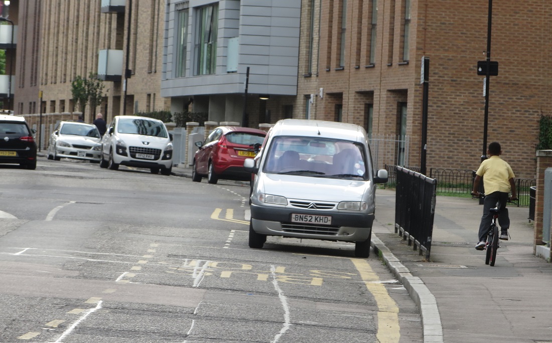
Car parking along both sides of the carriageway, two wide traffic lanes and a child cycling on a narrow pavement earlier today
Whether this is cycle tracks along both sides of the carriageway as per the Camden consultation or, if car parking was to be retained, a bi-directional cycle track instead

A bi-directional cycle track I used on a residential road in Breda, the Netherlands. The road as nowhere near as busy with traffic as Whiston Road is but it was a distributor road to other residential roads and also had one bus service running along it. 
Closing the two new roads north of Whiston Road to motor traffic so they are only accessible from Laburnum Street would ensure this cycle track was safe with no turning movements across it risking a collision. Between Haggerston Park and Pritchard's Row there would also be the space for this treatment if the proposed removal of on street car parking were to happen. I fear that the short stretch of Whiston Road outside Haggerston Park is probably too narrow for cycle tracks whilst maintaining two way traffic so perhaps a solution could be turning Whiston Road one way for motor traffic along here to accommodate a cycle track?

A one way street in Haarlem with ample space for two way cycling. Could a similar layout work on The Central London Cycle Grid in Hackney?

This would mean a short diversion of the 394 bus route, perhaps a quarter of a mile south of here via Hackney Road instead, but I would support this if this was to achieve safer cycling conditions, and I say that as a regular user of the 394 having used it twice this weekend.

In their 2015-2025 cycling plan Hackney Council state that they want to make Hackney's roads the safest for cycling in the UK and somewhere where it is second nature for everyone, no matter what their age to cycle. Unfortunately these plans will do little to achieve those aims. If Hackney is, as also stated in this plan, still serious about achieving 5% of primary school children and 15% of secondary school children cycling to school within a little over 8 years time then they seriously need to go back to the drawing board. Unless they want scores of children cycling on the pavement every morning then Hackney Council need to realise that riding in primary position outside of the door zone along Whiston Road, with motor traffic behind you will not appeal to most school children, never mind their parents. If this is what Hackney Council truly believes is a cycle grid then those targets will likely never be met. In the Netherlands 49% of primary school children go to school by bike and more than 90% of children aged over 12 do so, it is surely sensible for Hackney Council to look abroad (but beyond Jen Gehl) if their cycling targets are to be met and children in the borough are to remain safe on bikes.

The consultation closes this Friday 21st October, please respond here

Tuesday, 27 September 2016

Quietway 6

Tower Hamlets Council are currently consulting on proposals for their section of the quietway 6 cycle route. This quietway will run from Mile End to Barkingside and the section up for consultation runs from CS2 in Mile End to Hackney Wick on the eastern edge of the Tower Hamlets Border. Since CS2 and CS3 were completed I have switched my cycle commute home from work and now use CS3 and CS2 instead of battling it out with lorries on Hackney Road and cement mixer trucks on Bishops Way. It takes a little longer but it has literally changed my life having a mostly stress free and enjoyable cycle home from work at the end of each day. Presently I come off CS2 at Mile End and use the Regents Canal towpath up to Victoria Park; a very pleasant journey, if a little busy with pedestrians on sunny days. However very soon Victoria Park will be closing shortly after 4pm each day and so I'll have to find another route. As Quietway 6 will run very close to my flat in Hackney Wick this route sounds perfect for me and so I cycled home along it a couple of times last week to check it out.

The first section of this quietway begins by turning off CS2 and left onto Bancroft Road. This is not a welcoming manoeuvre to make as a much more welcoming cycle track stretches out ahead of you on Mile End Road! Every time I have cycled on Bancroft Road it has been busy, which is to be expected with the main entrance of Mile End Hospital located on it, Queen Mary University either side of it and, I suspect, people using it as a cut through from Globe Road to the A11.


I'm not sure a couple of "cycle friendly speed humps" will do much to change the environment here


The route quickly turns left into Alderney Road, where a continuous pavement is planned across the arm of the junction giving priority to pedestrians.


This is great to see but a shame more were not installed along the main road further south when CS2 was built. I'm also not sure why just this one side road gets this treatment in this scheme or even why this is part of a cycling scheme at all - why not just gradually introduce continuous pavements on every side road as part of every future road improvement scheme in Tower Hamlets?

Once into Alderney Road you're travelling West, the same direction you've just cycled from on CS2 so this doesn't exactly feel like progress. I found Alderney Road pretty busy as well with a fair amount of traffic and Mile End Hospital recommend this as a route to drive to the hospital if coming from the East, which possibly explains why. The route then continues round the North Eastern edge of Carlton Square, a very nice green area with pretty Victorian Houses along all sides of it. The plan is to create a "raised area to slow cornering vehicles" at the sharp bend at the top of the square, however from looking at the map a much better solution would be to filter the road here to create a pedestrian and cycling only section. This would also be a positive addition for pedestrians coming out of Carlton Green as well as creating quieter and safer streets for people living in the area


Continuing north along Portelet Road and it is interesting that in a ward where 66% of households have no car roughly the same amount of road space has been allocated for the parking of cars. Three "cycle friendly road humps" are to be installed along this road and my main experience of using these kind of humps is on CS1, which is mostly dreadful to cycle along. I did meet one speeding van but on the whole this street was fairly quiet and both times I cycled along here I saw someone having a driving lesson; a sure sign of low traffic! This area is naturally filtered as with the railway line to the North, the canal to the East and no way to cross either I would assume most people driving here will be either be a local resident or a visitor to the Hospital or University. I still feel a few additional "De Beauvoir Town" style filters would help create a nearly car free area and vastly improve the area for local residents.

At the end of this road Quietway 6 passes under the railway line on an already filtered road, albeit it one that is terrible to access.


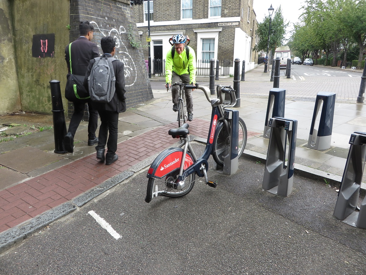
The cycle hire docking station will be moved from here and positioned onto the side of the roadway slightly to the left, so no longer any need to cycle up onto the pavement and back down again in a very tight space


If I was to suggest anything here it would be that cycles using Portelet Road and the underpass get priority over the busier Bancroft Road, or even better if the northern end of Portlet Road was closed with a Tiger Crossing leading into the underpass. The underpass itself will get "Lighting improvements and street art" along with "a contrasting surface at same level for indicative cycle track"

The recently refurbished "Dommeltunnel" bicycle tunnel in Eindhoven featuring a clear, smooth cycle track, pavement and a John Cleese Silly walks mural. Something similar here would be fantastic! 
Hopefully the road north of here will be resurfaced as it is in a terrible state and unpleasant to cycle on


The route then takes a zigzagged course into Meath Gardens and I had to get the map out to check which way to go. I'm sure it'll be clearer with cycle way finding signs painted on it but this route does not feel direct. In Meath Gardens itself a few quietway signs are due to be mounted onto posts, along with Shared use tiles inset into the path. Granite rumble strips are also planed to be installed to slow down cyclists but thankfully look easy enough to avoid as the ones in Hyde Park are. The path is a little narrow here - fine for locals to walk or cycle to and from the shops or work but I feel a separate cycle and walking path would be required if this became a well used cycling route, as is the case in Mile End Park nearby.


One things I am pleased to see is the two new apartment blocks either side of this path have direct access for people cycling to their homes, something I saw a lot in the Netherlands,

The route continues on a bridge over the Regents Canal, the same bridge Sadiq Khan used as a photo opportunity when he promised to make London a "byword for cycling" before he became Mayor of London. He is taking his time about it and four people have died cycling in London since he took office, so hopefully plans much bigger than this quietway will be announced soon.


As I cycled over the bridge I looked down onto the canal towpath I usually use to get home and it seemed to have taken longer to get here, having cycled an indirect 1.3km as opposed to .85km had I used the more direct route and stayed on CS2. At the bottom of the bridge the plan is to create a new path to replace the grass where the desire line is


And then routed into a "hidden" part of Mile End Park; tucked away behind the climbing wall it is not visible from the main park or canal path and so most do not know it is here. It is popular with sunbathers who want some peace and quiet but the signs warning that "Uniformed and plain clothed police officers patrol this area" makes me think this quiet and secluded part of quietway 6 is not a viable route to use after dark.

The Toucan crossing over Grove Road is to be widened from 4m to 6m but you still have to hop onto the shared use pavement and then back down onto the road, an awkward manoeuvre that risks conflict with pedestrians on the pavement. I hit the button on the Toucan crossing and waited. And waited, And waited. It was nearly a full minute until the green man appeared and I suspect many won't want to wait that long and will just cross the road on red. As I waited to cross I spotted a woman and her daughter cycling along the pavement on the opposite side of Grove Road and thought, not for the first time in this journey, how resources would be better spent on building protected space on main roads like this, rather than on quietway routes.


The route continues East along fairly attractive residential roads, although the majority of road space is, of course, given over to car parking.


The road is in a terrible condition in places so hopefully resurfacing will solve this


No new filters are planned and the one which has existed for many years is to be slightly improved by removing the two posts either side of the bollard.


basically returning it to how it was a few years ago

Image via google street view

A shame an actual "bicycle road" isn't planned to be built here instead, similar to this scheme on Brill Place in Camden

Image via google street view
After crossing a fairly busy St. Stephen's Road I was then cycling along what felt like an entrance into an estate car park, and the sign on the road then confirmed that is exactly what I was doing.


In a narrow access road alongside the car park I was eyed suspiciously by some local youths gathered around a moped and an aggressive looking dog being taken for a final dump before bed. I don't think I'll be revisiting this section again, especially after dark.

The route then goes onto a shared footpath and then down Galahad Mews, a very narrow alleyway which doors from the block of apartments alongside open directly onto. Surely only a matter of time before someone is hit by a bike as they exit their apartment block if this scheme goes ahead.


Had you been cycling along here a few years ago then you would have been cycling through the Safeway Supermarket car park. That supermarket was demolished some time ago and the site stood empty due to various planning issues. A new Tesco supermarket did finally open here a year ago with blocks of apartments built above it and on the car park with car parking transferred into the basement. The quietway passes between the Tesco entrance and the library, sorry I mean the Bow Idea Store, next door.


You'll have to negotiate through various street furniture and shoppers to progress, probably fine if you're cycling to Tesco but this is really not suitable as a long distance cycling route. It continues round the side of Tesco into Cardigan Road


Across Roman Road and over an improved filter on Libra Road (which is apparently blocked on market days)


And then into Centurion Lane to head north along Armagh Road, a road which I know fairly well and can say with certainty that this is totally unsuitable to be called a quietway. This road is busy and there is an awful lot of car parking in the estates and houses alongside


The plan is to create a "waiting pocket" in the middle of Old Ford Road in order to cross it to access Sycamore Avenue, this is needed as it is a busy road and I found it very difficult to cross last week.

The view of the current "cycling infrastructure" in place on Old Ford Road as you cross over it
It becomes clear the council are desperately trying to find a quietway, as you have to negotiate through cul-de-sacs


Before we run out of quiet roads and the route uses Parnell Road and Jodrell Road, overlooking the small fact that these two roads are lorry and concrete mixer superhighways


The plan here is to paint "Large cycle logos with chevron markings, placed centrally in each lane"


This road already has large "20" signs painted centrally in each lane and these are completely ignored. Speeding is a real problem along here


This road is very busy with motor traffic all day long and I try to avoid it at all costs, as do others. This is not at all a place for those "who want to use quieter, low-traffic routes, providing an environment for those cyclists who want to travel at a more gentle pace" and no amount of centrally placed cycle chevrons will change that.

The mini roundabout on Wick Lane is "to be consulted on separately" and no changes are planned at all for Cadogan Terrace alongside Victoria Park, which should clearly be filtered, particularly as the six lane A12 runs directly alongside so would hardly be an inconvenience.


Halfway along Cadogan Terrace and you turn right as you touch the border with Hackney, to travel on the hooped bridge over the A12

Not sure how that sign could have been damaged at 20mph
Which gives a good view of the quietway on Wallis Road below. It is a bit awkward to access from the bridge so ideally Wallis Road should be closed to motor traffic here and a tiger crossing installed a little to the left of where the current zebra crossing is located

Every single building in this photo to the right of Wallis Road is either currently, or very soon will be, demolished to make way for bland apartments in the sky. Expect an awful lot of construction lorries to be using Wallis Road over the next few years.
The priority at this junction will be changed so cyclists no longer have to give way to travel to the left under the railway line at Hackney Wick station


There used to be a mini roundabout here, which was removed just prior to the Olympics in 2012 and so it seems a shame to be spending money altering the layout of this junction again after just a few years. The road is very narrow under the bridge and I've lost count of the numbers of times I've seen buses almost collide here.


Once past this bridge you're in the London Borough of Hackney, where the quietway will continue into the Olympic Park into Newham and beyond, to be consulted on by different boroughs.

To cycle from CS2 to this railway bridge using the quietway route was about three miles, whereas had I travelled my usual route it would have been just under two miles. Ironically it also would have been a much quieter route along segregated cycle lanes, canal tow paths and Victoria Park and no interaction with concrete mixing lorries. Which leads me onto the question of why this quietway is being proposed at all? There are no real interventions here, it is mainly just adding signs onto some back streets. No filters or traffic reduction is planned and the roads will all stay the same as they are now, except for some reshaped speed humps. Almost every single street is too busy for children to cycle down and families won't be riding on this quietway when it is completed, just as they aren't now. 

Tower Hamlets Council state on the consultation page of this quietway that:

"Quietways are a network of high quality, well signed cycle routes throughout London which run along quieter streets, parks and other off-road routes across inner and outer London. The routes will link key destinations and are designed to appeal to people new to cycling and those who already cycle who want to use quieter, low-traffic routes. Quietways will complement other cycling initiatives in London, such as the Cycle Superhighways."

Yet very little of that is true when you experience this route on a bicycle. In their cycling strategy the council commit to building segregated cycle tracks along Grove Road, linking CS2 with Victoria Park. This is exactly what is needed, along with either a later opening of Victoria Park or segregated cycle tracks on somewhere like Old Ford Road (which would need to be made one way for motor traffic to achieve this). Tower Hamlets Council should be concentrating on building networks and grids along main roads, where people want to go and building cycling routes that connect some of the already excellent routes that exist. Filtering residential roads and building continuous pavements should continue as part of a programme to create better streets for all residents with the added benefit of giving children the option of cycling from their home onto a main road nearby where cycle tracks are available.

Quietway 6 just feels like the council have been given the funding and told they must produce a quietway in their borough. A real waste of resources.

The consultation closes this Friday 30th September. Please respond here.