A few weeks ago I wrote about changes to a street in the centre of Eindhoven, where a lane for private motor traffic had been removed to create greenery and more space for people walking and cycling and vowed to post again about changes to a main road leading out of the city.
Eindhoven suffered heavy damage in the Second World War from air raids with large parts of the city destroyed, with the city planners then destroying even more of it later on. It has a very 1960s feel to some parts of it, especially the area around the train station with brutalist architecture and people walking and cycling often having to do so via long underpasses beneath main roads and railway lines.
To the north of the city centre in the district of Woensel Zuid the old buildings and roads that remained after the war were swept away for new housing estates and very wide roads, such as Veldmaarschalk Montgomerylaan (the translation of which is Field Marshall Montgomery Avenue, named after the British army officer who led the operation to liberate Eindhoven), which is the road I used as I left the city to cycle to Den Bosch back in 2016
Veldmaarschalk Montgomerylaan in 2016. It had a very dated look, with a tiled cycle track that was barely distinguishable from the footway alongside and an odd hedge in the centre as the dividing line between the northbound cycle track and southbound track
The same spot in 2020 with a modern upgrade. The cycleway now has smooth asphalt and has centre markings, meaning the full width of the track can be used. The footway has also been repaved and is much brighter, with forgiving kerbs at the edge of the cycle track.
Slightly further north along the same road in 2016
The same location in 2020. The tree in the middle of the cycle track has been cut down to allow a bidirectional cycle track with no barrier, but many new trees have been planted between the cycle track and the road, which will grow to provide shelter from rain, sun and also from the noise of the roadway alongside.
However, this was not just an upgrade of the cycle track, this was a major transformation of a road built in the second half of the 20th Century from one designed to carry a large amount of private motor vehicles into the city centre, into one which instead prioritises public transport.
This is the southbound carriageway of the road taken from Google streetview a decade ago. It shows the post war layout that had been here for decades; a very wide road with multiple lanes for motor traffic in both directions and a very wide central reservation between them
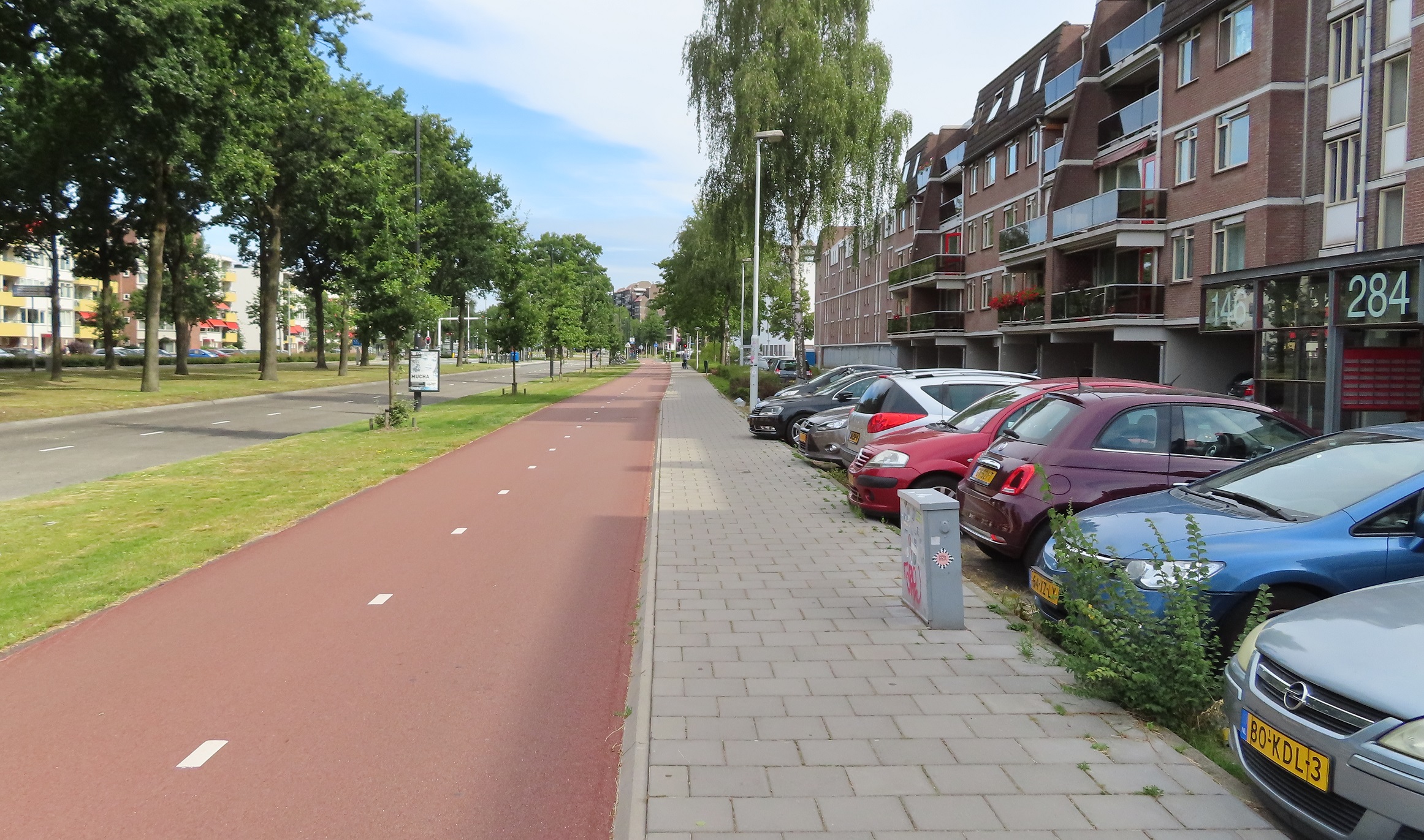
The same spot on the most recent streetview capture. What was the southbound carriageway has now been reconfigured to carry traffic in both directions. Along most of this road motor traffic now just has a single lane in each direction; it is only at the junctions that additional lanes appear for motor traffic to turn off the road
This was the northbound carriageway a decade ago, a minimum of two lanes for motor traffic at all times, gaining up to five lanes at the junctions, now motor traffic just has a single lane on the other side of the central reservation
The same location as above in 2020. What was the northbound carriageway is now a dedicated bus only expressway, giving buses a clear route into the city centre and no longer being delayed by motor traffic, along with the added bonus of an upgraded cycleway alongside
The new bus expressway only allows buses to use it, so unlike in London there is no sharing with taxi's or motorbikes (who use the adjacent roadway) or bicycles (who have a dedicated cycleway alongside) so the bus drivers can drive here with no interactions with other traffic or any delays. Although of course this bus expressway can also be used by emergency services giving them a clear route to quickly attended any incidents and improving response times. Here is a video of the bus expressway in use:
There are regular crossing points for people walking and cycling and these are placed on the desire lines, usually alongside the bus stops, which are also located next to junctions giving pedestrians who have either alighted or are going to catch a bus a crossing right alongside the bus stop, and people cycling east to west across the road, or turning off the cycleway to turn left, a crossing where they need it to be.
One thing I noticed is that these crossings were quite often default green but when a bus approached they always remained red and an audio warning sounded, along with a flashing bus icon to warn people not to cross. This results in buses not being delayed at crossings and reduces the possibility of a collision between a bus and anyone walking or cycling
At each bus stop there was always plenty of cycle parking, allowing people to cycle to the bus stop to catch the bus, and then cycle home afterwards when they return
Back in 2016 as I cycled along here the road expanded out to four lanes as it approached the ring road
Now, it is just a two lane bus expressway with new trees between the upgraded cycle track and the bus lanes
Although I didn't notice this as I cycled through here last month, the ring road has also been buried in an underpass under the road, with additional bidirectional cycle tracks created on all sides of the junction. The image below shows the changes from Google Earth satellite imagery (with the new layout still not fully complete)
Once again I couldn't help notice as I approached the junctions that the buses always seemed to have a green light as they approached, with all cars and cycles receiving a red light. The new layout really does put people on public transport first and creates a fast bus expressway that is not being delayed on its journey in any way, except when passengers board or alight.
This new layout continued all the way up Veldmaarschalk Montgomerylaan for another two miles, giving me a comfortable safe cycle route alongside the buses which sped past me every few minutes. I then came to a road named Winston Churchilllaan (I told you these were post war roads!). Once again the same layout continued along here east out through the suburbs, with a check of google streetview showing that the same upgrade had been implemented; a wide multi lane dual carriageway for motor traffic replaced by a bus expressway with just a single lane for motors
The same road two decades apart from streetview; a dual carriageway with cycleways either side to a single lane for motor traffic, a bus only road, along with upgraded cycle tracks
After another couple of miles the residential buidings alongisde gave way to fields as I exited Eindhoven but the bus expressway continued (although the bus lanes split and crossed over here to run either side of the road). Again I was surprised to check goggle streetview to see that what was a rural dual carriageway had also been reconfigured and reduced to a single lane to allow a fast bus route from Eindhoven out to neighbouring towns.
Google Earth satellite imagary shows the road leading east out of Eindhoven through fields to the town of Nuenen in 2009, a dual carriageway with cycle paths either side of it
The same road a decade later. There is now just a single lane for motor traffic in either direction. Separate from that road are bus lanes either side, allowing buses to get from Nuenen directly to the centre of Eindhoven without any delays. The cycle tracks either side have also been upgraded and widened - now with red asphalt and centre markings to show they are both bidirectional
As I cycled between Eindhoven and Nuenen I did so behind a family; a mum with her young daughter of primary school age alongside and her not much older son up ahead of them, safely cycling alongside a rural main road in perfect safety
I cycled behind them for a couple of miles; obviously I don't where they had been cycling from but assuming they were cycling from the centre of Eindhoven to Nuenen then they would have cycled just over seven kilometres or nearly five miles, which is perfectly normal for Dutch families. Now nobody is forcing them to do this of course but the safe and direct cycleway gives them this option. They could have taken the bus, which probably would have been quicker and would have not been delayed at any junction or by any other motor traffic due to the new fast expressway. They would have used an OV-chipkaart for this journey, which is a travel card that allows entry onto any bus, tram or train in the entire country. It also allows access to underground bike parking facilities at train stations and use of the OV-fiets bicycle hire.
Eindhoven has a population of roughly 220,000 so about the same as a British city such as Reading, Luton or Wolverhampton. Imagine a mother and her two young children making a journey to and from a town five miles away from those cities. The bus would be expensive, have an irregular timetable and almost certainly held up by other motor traffic. I can't envisage any of these cities getting rid of a dual carriageway anytime soon! As for a family like this cycling on a main A road or dual carriageway in the UK? Well, it might be legal but it would almost certainly not happen as it would be incredibly dangerous thing to do with no separate cycling infrastructure and motor traffic moving at very high speeds. The default option in the UK would be to drive, with little incentive to use any alternative mode of transport.
Whilst I mostly concentrate on writing about Dutch cycling schemes on here it is worth remembering that the Dutch are also vastly improving their bus, metro and train services, whilst also improving cycling and walking conditions. Many councils have declared a climate emergency but I don't see any reallocating space on their roads like the Dutch are to help achieve this.
Every year when I visit the Netherlands I encounter changes to their road layouts and often remain surprised at how they change and upgrade their roads constantly. This year it happened within seconds of arriving, as the ferry terminal has been completely reconfigured with the previous road removed and replaced with a cycle track that now leads directly into the ferry terminal. I also wrote a thread on twitter about some of the many changes to the road layouts in Amsterdam I saw this year, compared to only last year. I have visited Eindhoven just once before, back in 2016 (only a few days after the UK voted to leave the European Union). I knew that there was bound to be changes to some of the road layouts in the city in that time and so will document two of them I encountered here.
Eindhoven has a rare layout for a Dutch city but something which is very common for a UK city - a one way system surrounding the city centre for motor traffic
The one way system for cars that surrounds the city centre of Eindhoven. Within this ring are mostly pedestrianised or cycling and walking only streets. Mostly shops to the north and many bars and restaurants with outdoor seating to the centre and south. There are also a few busy east / west routes through here for people cycling but driving is largely not possible, or for access only
When I visited Eindhoven four years ago the section of road to the east of the city centre that formed this ring had two lanes for motor traffic in one direction with a contraflow bus lane in the opposite direction, then uni-directional cycle tracks (or in a few places painted cycle lanes) on both sides of the road, allowing cycling in both directions anywhere on the ring road.
The eastern section of the inner ring road in Eindhoven in 2016. A contraflow bus lane and two lanes for motor traffic in one direction, with pavements and cycle tracks on both sides
The local authorities took the decision to improve this road, not by removing the one way system, but by keeping it but removing one lane of motor traffic to create more space for people walking and cycling.
The same location as the photo above, four years later. By removing a lane for motor traffic it has allowed space for a wide bidirectional cycle track with greenery and cycle parking on both sides of it
The new road layout is brilliant, the greenery between the cycle track and bus lane is lovely
The greenery also breaks up at regular intervals for cycle parking, which is plentiful
The new cycle track is very smooth, with drainage located along the kerbs at the side of the track
Although I had no idea back in 2016 that these changes would occur I took quite a few photos of this road from the cycle track so can manage a few before and after comparisons but google streetview does a good job of showing how much road space has been taken here
2016
The same location in 2020. By removing a vehicle lane and one of the cycle tracks there is room for a wide bidirectional cycle track and greenery along both sides of the road to shield people walking and cycling from the noise of motor traffic.
2016
Plenty of new trees and plants have been added
It's difficult to work out exactly what space has been taken from where and reallocated as the entire road has been reconstructed from building to building. The footway, cycle tracks and roadway have all been dug up, all the trees that were there have been cut down and even the drainage has been moved so the only real reference point to compare the two are the buildings alongside the road.
2016
2020
In the photos below the manhole cover at the edge of the cycle track is the only marker to show the footway space stays roughly the same, trees have replaced the cycle track, the new cycle track is where the bus lane was and more trees where the roadway was. I assume part of the old cycle track on the other side has become roadway but it is difficult to tell
One of the few photos I took whilst cycling on the other side of the road back in 2016
The cycle track here has been replaced by trees and greenery.
and in some places there was only a painted cycle lane meaning anyone overtaking had to use the lane for motor traffic, but now they have a wide bidirectional cycle track on the other side instead
In some areas the footway has been increased
The new bidirectional cycle track is very wide
2016
2020
The lorry driver here decided to change his route and so turned round and drove up the cycle track. He's not supposed to do that of course, but it does help illustrate just how wide the new cycle track is
I remember stopping to take the photo below back in 2016 as I thought it was a good example of a continuous footway and continuous cycle track passing the vehicle entrance to a service area of an office complex
It still is a continous footway and cycle track passing it, just that now it is a bidirectional cycle track.
That border between the cycle track and roadway normally filled with greenery or cycle stands also acts here as space for the driver to stop and wait for any passing cyclists before crossing the cycle track to gain entrance to the service area, as happened shortly after I took this photograph
There are some improvements to the busy cycle routes running east / west across here too. Previously Ten Hagestraat had a poorly marked "cycle area" as it exited the shared pedestrian and cycle zone, which has now been removed
2016
2020
Replaced with a bidirectional cycle track on the opposite side of the road
This continues along Kanaalstraat, which is a very busy route for people cycling east out of Eindhoven. Previously this road had a narrow painted cycle lane on either side, with not enough room to even cycle two abreast
The entire roadway has now been shifted to the right, with the cycle lanes and an approach slip road to car parking removed. That has allowed space for the wide bidirectional cycle track on the other side of the road, with greenery alongside
I didn't manage to get a "before" photo of the other side back in 2016 but the improvement is clear I think!
This has been a really wonderful upgrade to the city centre but the changes are only halfway complete. The western section of the ring road (northbound for cars) has not yet been altered and remains exactly the same as it was in 2016. It's only when you cycle here that you truly can appreciate what a great upgrade this is. The old layout with three remaining lanes is noisy, with too much motor traffic, often quite close to you. The cycle track is narrow so whilst you can cycle two abreast that does not leave much room for others to overtake
and with a narrow footway there are places where pedestrians are forced to step out into the cycle track
I look forward to returning to Eindhoven again one day to see this project omplete. Next week I will write about a different upgrade I encountered to a main road heading out of the city. For now here is a five minute long video of me cycling the entire length of the new layout, from North to South. This was filmed on a Monday evening with schools and universities closed and many people still working from home so was very quiet. It was much busier the night before on Sunday as people made their way home from bars and restaurants in the City Centre:
Note: I have added a donate button to the top right of this blog, as I have recently been made redundant. Whilst there is of course absolutely no obligation to do so, if you do enjoy my videos on twitter or rare posts on here then any donation would be greatly received and will be used to fund this 2020 trip to the Netherlands
I spent the first two hours of Tuesday morning cycling around Eindhoven and it was impressive at just how pleasurable it was to cycle around such a busy city (with a population of around a quarter of a million people) during the morning rush hour. I described in the previous post how buses were prioritised (along with bicycles) leading from the airport into the city and the situation was similar in the city centre too. Eindhoven has two roads surrounding the (mostly pedestrianised) streets in the very centre of the city, both are one way for motor vehicles (with bus lanes) but with cycle tracks in both directions; positive both for bus passengers who are not delayed behind bicycles as well as for children, enabling them to cycle on these roads. All main roads had cycle tracks of course, along with other cycle only routes, such as the Dommel "silly walks" tunnel. This tunnel is an unusual and interesting place to visit but more importantly it is a well used cycling and walking only route under the railway lines which links the University on one side, with its own network of cycle tracks, with the city centre on the other side, forming a grid of safe cycle routes. Half a kilometre west of this tunnel is another cycling and walking only underpass under the railway lines and the Inner ring Road. Inbetween is a road underpass, with bi-directional cycle tracks along both sides of it, and so the list of why so many choose to cycle here goes on. It was great to see so many people cycling along such busy roads and emphasised what tosh it is when people claim cycle tracks wouldn't work in a busy city in the UK with high bus use. As I stood at one junction that morning taking pictures I saw a mum stop at a set of traffic lights and kiss her child on one of these main roads and felt a bit jealous. I do this to my daughter when I cycle with her in Hackney but do so on the canal or in Victoria Park, why can't we create safe cycling conditions like this on a street in Hackney with buses too? I wasn't originally planning on visiting 's-Hertogenbosch and this journey was going to be Eindhoven to Nijmegen but my friend and fellow blogger Mark Wagenbuur invited me to visit the city where he lives, and so I cut my planned visit to Utrecht down to 24 hours and fitted a visit to 's-Hertogenbosch into my trip instead. Following the morning rush I looked at pictures of Boris Johnson and protests in London under the headline "regrexit?" over breakfast , surprised at just how many pages of this Dutch newspaper were devoted to the Brexit story. I then began my journey north out of the city on a wide road that was closed to motor vehicles due to roadworks. This road was very wide and the main road into the city from the north and so I was amazed that all motor traffic had been removed whilst renovation took place. A bi-directional tiled cycle track was still open along the eastern side of the road but this track was clearly very old with an odd "dual carriageway" arrangement.
I did wonder if this track will also be rebuilt at some point as part of these works. Removing that rather pointless central reservation would make for a much wider track, hopefully with some nice smooth red asphalt, although it is already wide enough for people to cycle side by side in either direction as it is. The familiar sight of red asphalt returned as I cycled through a couple of junctions before coming to more roadworks where this time the cycle track was closed along with most of the roadway. The lady in front of me simply cycled up onto the pavement and so I thought I would copy her and continued on the pavement up to the centre of the large junction. Again, this junction was absolutely enormous and clearly where two major roads meet but almost all of it was closed to motor traffic. A new looking bi-directional cycle track had been built on the southern side of the junction and so I hopped round the construction barriers to take some photos of it.
Just as I was doing this one of the construction workers spotted me and started walking in my direction. The last time this had happened back in London a construction worker had gotten very angry and shouted at me to get out and so, expecting similar treatment, I mentally prepared my "dumb British tourist" routine. He said something to me in Dutch and when I told him I was from the UK he pointed down to the cycle track: "Do you like it?" he asked. "Oh.. yes it is lovely, looks very smooth" I replied. He shook his head and looked down at the track in disappointment "No, it is not good" he replied, "It is not smooth enough and look at the red stuff on there." I noticed an inch or so of red asphalt had made its way onto the pavement at the edge of the cycle track. He knelt down and pointed out the other edge of the track "Those edges, they are really bad. It isn't meant to look like that". He stood up, shook his head one more time and said "it is shit." I must say it looked great to me and I would absolutely love a cycle track of this quality to be built in London but I wasn't going to argue with a Dutch engineer who builds cycle tracks for a living. "Have a nice day!" he said, leaving me in the middle of the worksite. I walked over to the northern side of the road and took a picture of the bi-directional cycle track there too, wondering if this was also shit. I continued north and the road was initially wide but then narrowed as the area became residential, I passed a park where a mother and her young child were feeding bread to the ducks and geese from the bike. The road ended at a T junction but I was able to continue straight ahead on a bicycle road which led me onto a cycle track through a residential area, I crossed over several quiet residential roads, some of which even had cycle lanes on them but it was clear that driving and cycling routes had been built separately from each other on this housing development. The cycle track continued into fields and led me under the A50 motorway and into an out of town retail development where I kept to cycle tracks past IKEA and various other retailers, safe from the lorries servicing them and industrial businesses in the area. I passed over the Wilhemina canal and cycled alongside the A50 motorway with trees and a drainage ditch between us muting the sound a little.
A family of four out on bikes; the woman has a young child up front on a seat attached to the handlebars
I soon turned off onto a path which led me thorough parkland, where I admired a castle in the distance, into the town of Sint-Oedenrode. It was back to sharing with motor traffic in the town although motor traffic levels seemed very low with most people getting about by bike. I stopped at a cafe for coffee and cake and sat outside watching people going about their business. Motor traffic using the road moved through at a slow pace, due to the design of the road, rather than just painting ugly "20" signs in six foot high markings on a tarmac carriageway and not restricting motor traffic, as would happen in the UK. After coffee I cycled through "Markt" the main square in the town, which was pretty but a shame most of it is used as a car park. I turned off into a road that became a dead end for cars but paths continued with small bridges over the river before the path lead me onto a main road. The cycle tracks here varied between tiles and a worn down path, some smooth red asphalt would have been lovely but overall it was fine to cycle along. I turned off this road and continued for the next 7km along country lanes under a very hot sun, again these roads looked very similar to a small country roads in Britain, except these had a 60kph speed limit as opposed to the 100kph that they would have had back home. There were also had raised cobbled areas at every junction, presumably to slow motor traffic down at the places where collisions are more likely to occur.