Showing posts with label Fish Island. Show all posts

Thursday, 7 December 2017

The Olympic Park in 2017, Part Four: Sweetwater and Fish Island

Sweetwater is the next stage of the park to be built, located in the borough of Tower Hamlets it will house 650 homes, a primary school, two nurseries, a health centre and a library. Sorry, I mean an idea store. During the games this area was where the worlds largest McDonald's was briefly located, along with the London 2012 Megastore. Prior to 2007 it housed the Bow Industrial Estate and Carpenters Business Park. To the west of Sweetwater, on the other side of the River Lee Navigation, lies Fish Island, not officially part of the Olympic Park but undergoing a huge amount of building works right now and under the jurisdiction of London Legacy Development Corporation planning department.


The only current way to enter this side of this area of the park by motor vehicle is via White Post Lane, which used to begin at Victoria Park, but now begins on the other side of the A12 with the first section due to form part of quietway 6. Most of it runs along construction sites at present but as it reaches the Olympic Park it runs past the former six storey Clarnico's chocolate factory (now mother studios) and the two storey white building, originally built to roast imported cocoa beans arriving via boat (hence the name Sweetwater), and now the White Building and always popular Crate Brewery and Pizzaria. This road was closed from 2007 through to 2013 and as a local I got used to the pleasant silence of the area and so it was quite a surprise when it originally reopened to motor traffic but four years on I've grown used to it once again


Crossing over the narrow Victorian bridge into the park and the road becomes Carpenter's Road, which used to be much narrower than it is today before Olympic Park construction began.

Carpenter's Road at the junction with Waterden Road in 2007, via Diamond Geezer on flickr
The same junction in 2017, with this section of Waterden Road now renamed Clarnico Lane


From the other side, Carpenter's Road at Waterden Road in 2007 via Sludge G on Flickr
The same junction in 2017, with the bridge and former Clarnico's factory in the distance the only remaining features. The road has been significantly widened 

Zooming out from the image above gives you a clearer view of just how wide the road is, yet despite the post Olympics widened layout the only facilities for people cycling are narrow, intermittent cycle lanes, which give up at every bus stop and junction


The road continues sandwiched between the North London line and what will become Stratford Waterfront in the future but was a beach when I took the photo below this summer. Prior to that it was the Water Polo Arena in 2012 and fridge mountain before Olympic Park construction began

You may just be able to make out the two cyclists in the photo on the footpath, shortly after the wide exit from the Aquatics Centre car park and what must be the least used zebra crossing in London
Carpenters Road continues past my local swimming pool

Again, can you spot the cyclist on the footpath in the bottom left?
This junction is gigantic, yet only narrow cycle lanes are all that is provided. This T junction existing prior to the Olympics

The same junction from google earth in 2005 and today, captured via google earth. It was a T junction but much smaller and located slightly further south 
The junction of Carpenters Road and Warton Road before the Olympics (©2004 Peter Marshall mylondondiary.co.uk) and the same location, renamed Swimmers Lane in 2017

Carpenters Road still continues under the railway bridge, as it did before the Olympics, but by making a left turn. The road continuing straight on becomes "loop Road" so called because it, along with Carpenters Road, loops all around the southern half of the park. Once under the railway bridge it passes through Carpenters estate, which Newham Council would really like to demolish to sell off to property developers, and onto Stratford High Street and the segregated cycle tracks of CS2

Back in Sweetwater it is clear to see how much space this cyclist has on the pavement, compared to the narrow intermittent cycle lanes on the road

Clearly no space to provide protected cycle infrastructure here!
This is exactly what I do when I take my daughter to her swimming lessons by bike every week, as I just don't feel it is safe enough on the road, risking mixing it with left turning lorries and cars travelling at high speed on this wide, straight road and in my experience, most people here tend to use the pavement


Probably for the same reasons, parents are naturally protective of their children and want to keep them away from danger


Also all the attractions, such as the Aquatics Centre and Westfield, are located south of this road and sometimes there just is no dropped kerb to allow you to hop off the pavement to get onto the road


There are usually very few pedestrians along here so this isn't an issue at present, however once Sweetwater is built then residential properties and the library will be located along this road and so it'll become a busy pavement. There is clearly enough room for cycle tracks either side or a bi-directional cycle track along here; if located north of the road then it would run between the road and the railway track, and with Clarnico Lane also due to be removed soon it would have no side road conflict, just as CS3 doesn't along the Embankment. However it would be on the wrong side of the road to all the properties and amenities, so ideally should be placed along the south side of the road instead. As construction has not started on Sweetwater yet and so there is still the time and space to build it,  the bridge is also very wide so it can easily be accommodated.


Do they seriously expect parents to cycle with their children to the library, nursery or primary school on Carpenters Road as it is, with those narrow cycle lanes?

Once you pass under the White Post Lane bridge along the Lee Canal Towpath the new canal park appears.


It is very pleasant but once again I do wish some of the space could have been used for a wider path

The towpath when I cycled this route back in 2007, with the Bow Industrial Estate boarded up but not yet demolished, and the same location today
Or at least a simple diversion onto a cycle track alongside the road along here but this was reconstructed in 2014, with no dedicated space for cycling, just a narrow road and a gigantic pavement

During the Olympics and three years later
As I reported in this blog earlier this year, this road has a realigned extension built just under a year ago and despite the space available, narrow advisory cycle lanes were painted onto the road, which is so narrow cars have no option but to drive in them


Bobby Moore Academy opened it doors to local school children in September. This site next to Sweetwater will be a primary school, however at present the secondary school is still under construction a short distance  away on the loop road on the other side of the stadium and so year 7 pupils are currently housed here until they transfer next year and reception children take over. I cycled this way one day at 3.30pm in the first few weeks of it opening and was not at all surprised that the mammoth pavement was being used to park cars on the school run


Just imagine how busy this road will be at 3.30pm in a few years when the full number of 400 pupils are based here, along with another 1000 around the corner in the secondary school!

Before and after. Why paint  narrow cycle lanes on such a narrow road with all this space available?
As the loop road continues round the edge of the stadium it passes over a new bridge over the River Lea, constructed during 2009/2010 and then loops around the stadium

The loop road in 2012, taken from google street view, when it was part of the service road used by athletes and the media during the games and the same spot today. Plenty of space to provide protected cycle tracks that the pupils from both the primary and secondary school located on this road could use to get to and from school
Whilst the road is currently closed outside the secondary school, as it forms part of the construction site, it is now possible to travel from Hackney Wick directly to Stratford High Street via this route, something that was not possible before this became the Olympic Park. These roads will get much busier over time

The north side of Fish Island was traditionally a place where people lived in Victorian Houses and worked in the various factories, such as Clarnico, or in the warehouses along the rivers and canals in the area up until the 1970s when they were demolished for more modern industrial units. Many of those industrial units have recently been demolished to once again house people and so a large area of it is currently a building site

The north side of Fish Island, a year apart
A lot of the old warehouses remain on the South side of Fish Island, mostly housing artists studios but with some well known businesses, such as Trumans Brewery, Formans smoked salmon and the Morning Star newspaper all based here in newer buildings.

The former Wick Lane Rubber Works, built in 1889, now housing artist studios 
At the end of Monier Road, the main road through the middle of Fish Island, a new apartment block, Carpenters Wharf, nears completion.


You can still travel back in time on google streetview to see the Carlton Cafe and warehouse as it was before demolition but in the present day the chimney with "Carlton" painted on it is the only reminder of it (although named after the shoe company who were once based here). Fish Island remains a quiet place to walk or cycle as it is naturally filtered by water or sewers. All motor traffic in the area is there for a reason, not using it as a through route to somewhere else. Unfortunately the London Legacy Development Corporation still want to tear down the popular walking and cycling bridge over the Lee Navigation. After I wrote about this plan on here last year I wrote to Caroline Russell and she kindly asked the Mayor about this bridge, and this was his response:

"The H14 all modes bridge is anticipated to have a speed limit of 20mph and has a narrow road width. It is unlikely that there will be an issue of rat running, as this connection would not provide any journey time savings or represent an obvious short cut for anyone using the existing strategic road network.
These bridges are part of the regeneration strategy for the area which is designed to rectify some of the long standing problems of isolation, caused by the large numbers of waterways and major trunk roads which have had a long term debilitating effect on the immediate local economy. I am informed that the construction of these bridges will help ensure that the Hackney Wick and Fish Island communities will have access to the world class facilities of QEOP, including the new schools, thousands of new homes, healthcare centres and other amenities. This will be a significant economic and social benefit for local residents."

Firstly, most roads in the Olympic Park are 20mph but speeding remains a real issue on many of its roads. Also you can tell Sadiq does not cycle and narrow main roads are terrible for cycling!


Next year if this child wants to cycle here then he'll have to do so in the centre of a narrow road to slow down speeding lorries

As for it to be unlikely that rat running will be an issue here, that is quite clearly not true

The new road and bridge running from left to right at the bottom of the map. It'll connect directly to the Loop Road, which in turn connects directly to Waterden Road to the north and Stratford High Street to the south. 
The mayor has been incorrectly informed that this bridge will help ensure that the local communities have access to the world class facilities of the park, schools and other facilities on the other side of the water as they will already have that due to the walking and cycling bridge that already exists! It is well connected already, unless you're a driver looking for a rat run. For those small number of residents that need to drive to those facilities then they are perfectly able to by using an existing bridge 250m away


If the Mayor is serious about tackling air pollution then why on earth would he back the building of this road?

Fish Island is an area where everyone can access all roads by car but there is no through traffic. I find it astonishing that as locals councils such as Hackney and Waltham Forest meet opposition to try and filter residential roads we have a community that already has filtered roads and the plan is to undo that. What Hackney Wick and the surrounding area needs is more pedestrian and friendly routes, not more cars. 

When I was in the Netherlands this summer I visited an area called Oosterheem, in Zoetermeer. Like Fish Island and Sweetwater it is an area with new housing and is split in two by water. Below is a map showing the routes cars can take, in black, and those that people can take by bicycle or on foot in green (although both of the road crossings also have segregated cycle tracks and pavement)


These bridges provide routes for people to cycle or walk from their homes to visit local amenities, such as shops, schools or friends in the area but make it less appealing to do so by car 


They continue on as direct routes through the local area, completely separate from the road network


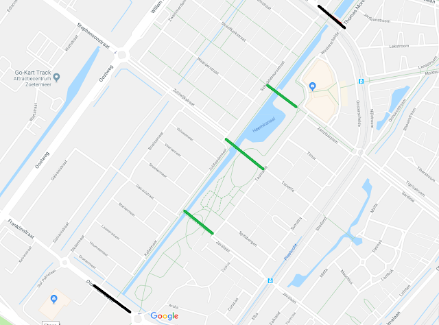
These are intersected by other routes creating a real network of cycle routes that are quick and essentially safe for anyone to use, no matter what their age.


Below shows the local school and nursery on the left, with another direct and continuous  cycle track past it that continues over the water in the distance. The roads do not and are only used as access roads so whilst everyone can drive to their destination it is much easier to travel around the area by bike or on foot


The residential roads are carefully arranged to ensure they are only used by motor traffic accessing those roads for a purpose, rat running is not possible and the roads are designed for low speed traffic.

These are the kind of implementations Sadiq Khan should be encouraging for Fish Island and Sweetwater if he is serious about cleaner air in London, not ripping out popular walking and cycling routes to create yet even more roads for rat running motor traffic in the Olympic Park.

Nobody except the London Legacy Development wants this bridge. Local residents do not want it 


Future residents of Fish Island and Sweetwater, if they have quiet roads and safe routes to cycle on, surely wouldn't ask for a new road bridge once they experience how pleasant it is to live in such an area. John Biggs, the Mayor of Tower Hamlets does not want his bridge. Rushanara Ali, the local MP, does not want this bridge. Sadiq Khan has the power to tell the LLDC to halt the construction of this bridge and he should do this to save Hackney Wick and Fish Island from more motor vehicles, more pollution and a worse quality of life.

Next Post:
Part Five: The Stadium, Marshgate Wharf and Pudding Mill

Previous Posts:
Part one - East Wick
Part two - East Village and Chobham Manor
Part Three: Westfield Stratford City

Thursday, 9 February 2017

A new road in the Olympic Park

I first wrote about the Olympic Park back in July 2013, a year after the games had taken place and just after the Northern section of the park had reopened to the public. I revisited the park again with another post in 2014, just after the Southern half of the park reopened, followed by another post in 2015 to mark two and a half years since the end of the Paralympic Games. It was always my intention to revisit the park and write about it this summer, in order to mark five years since the games took place. However a new road is currently being constructed in the park, so that'll be interesting for everyone, I thought.

Currently in the very early stages of construction on the Western edge of the park, on the other side of the River Lea from the stadium, is Sweetwater; a new community consisting of around 650 homes, a primary school, two nurseries, a library and a health centre. Sweetwater will be located in the small area of the park that lies within the London borough of Tower Hamlets. No sporting activities took places here in the Summer of 2012 but it did contain the worlds largest McDonaldsthe London 2012 Megastore (which is where I bought my Team GB hoodie from, and which still gets the odd wearing to this day). It also served as the space where Gary Lineker and others presented the BBC coverage from the top of a stack of shipping containers along with a storage space for games vehicles to park up behind the Megastore and McDonalds. Prior to the Olympics, up until July 2007, this area was home to the Bow Industrial Park and the Carpenters Business Park, sandwiched between the River Lea and the Lee Navigation.


The two industrial estates as they were before demolition in 2007, taken from Google earth. I've drawn a red line to indicate where the main road ran through the Bow Industrial estate, from Carpenter's Road down to the old Planet 24 building behind the old Big Breakfast house / TV studios
The same view during construction of the park. The former road through the industrial park is now part of the main orbital road used by construction vehicles and buses ferrying workmen between the various sites. Note the two new bridges over the River Lea at the end of this road, one temporary for construction vehicles and a wider one alongside, designed for a post games park. 
The same view again, this time during the summer of 2012, just before the games began. This road is now part of the orbital service road, used to ferry athletes, journalists and other officials between the various venues, broadcast centre and Olympic Village. Note also the new footbridge halfway down the red line
Following the Olympics this area remained a vast empty site, fenced off from the public. Below is a picture I took in the spring of 2014 looking down the former Bow Industrial Estate Road from Carpenter's Road through a gap in the barriers, with the view looking much the same as it did during the Olympic Games


This road was then reconstructed shortly afterwards


with the final layout pictured here, in the summer of 2014


The road shifts to the left instead of continuing straight on, as it used to, in order to accommodate a canal park and an elevated bank at the end of the pedestrian footbridge mentioned above, which had been constructed prior to the Olympics but simply ended in mid air for several years. Despite the vast space available no dedicated cycling infrastructure was constructed, the roadway remained narrow with all the space being spent on a mammoth pavement, which almost everyone now cycles on. Here is an image of the service road during the Olympic Games, taken from Google Streetview 


and a view of the same location, taken last weekend, below


I'm really not keen on the current trend of wasting space on colossal pavements and then expecting people to cycle on the road directly in front of motor vehicles. So wide is the pavement here you can even see it from space on google earth

The same area as it is this year, captured by Google Earth
After passing the new footbridge leading onto Fish Island the road then curves again at a right angle to rejoin its old course alongside the edge of the water, a lightly used section of road that usually contains many more parked cars than those being driven and was often dominated by people cycling instead, especially at weekends


However this section of the road passes through where a new Primary school is due to be located and so, just before Christmas, as the builders moved into start work on the new school, the Highways engineers also moved in to alter the course of the road. The entire site was fenced off and so I could only get a look at the start of the new road, by the Fish Island footbridge


and the end of it, at the back of the old Big Breakfast House near to the bridge over the River Lea

The southern end of the new road, note the construction site of the new Primary school alongside
It was quite clear, even at this stage, that this new road was not going to be wide enough for any segregated cycling infrastructure. The pavement alongside is probably about three to four times the width of the road and so I hoped to come back and see the engineers constructing a lovely new smooth cycle track between the road and the pavement for future generations of children to use to get to school. I returned last weekend to see how progress was coming along and despite witnessing some very poor road schemes built within the park in recent years even I was surprised at what I found

Advisory cycle lanes. Useless.
The road is still fenced off and so, as tempted as I was to sneak through and takes pictures from within the site, I had to make do with taking pictures either through gaps in the fence or over the top of it instead.

The road is pretty narrow here. Whilst two motor vehicles could pass each other side by side they would certainly both have to drive in the cycle lanes


Further ahead and the cycle lane pauses for the yellow zig zag lines outside where the school entrance will be, before continuing in the door zone of a lay by


and then pausing again for a zebra crossing and a pinch point where the road narrows


and then a fun looking slalom where I'm not sure I'd trust any speeding motorists to not swerve into the opposite cycle lane as they overtake someone in the cycle lane


taking us back to the Fish Island footbridge


The gigantic pavement which remains has been a well used cycling and walking route since this area reopened to the public nearly three years ago (known as Marshgate Terrace) and here is a picture from Summer 2015


and a view from the same area this weekend


Hopefully you can just about make out those narrow advisory cycle lanes in the background! Another view from 2015:


and the same view now:


Here is another view at the end of the route two years ago, it was fenced off back then directing you onto a now closed path leading to the towpath on the Lee:


With a view from the same angle last weekend:


There is easily enough space for the four teenagers on bikes to cycle side-by-side with room to spare, and that is still with half the pavement area fenced off. Soon they'll be expected to cycle in single file on that narrow advisory lane to their right! Of course that is unlikely to happen, the vast majority of people here will cycle on the pavement, just as they do further north already. It is, of course, entirely possible that some kind of cycling infrastructure will appear on the pavement here, which is crap for everyone

Two Tier cycling provision in another area of the Olympic Park. A cycle track on the pavement which gives up at every junction and becomes a shared use pavement with "cyclists dismount" signs, alongside an ASL on the road
A cycle track along the new Chobham Manor development opposite the Velodrome, safe for children to use but it is narrow, gives way at side roads and you are meant to dismount at the pedestrian crossing to get to it. Note the lone adult on the bike (understandably) using the road instead

Another reason that many cycling here will use the pavement is that, despite the double yellow lines, it is likely those cycle lanes will be filled with parked cars during the school run. This is exactly what happens every morning and afternoon at my daughters primary school in Hackney and also in the other school already open in the Olympic Park

Home time at the Chobham Academy, many cars parked on double yellow lines and on the pavement

Imagine if there was a network of cycle tracks in the Olympic Park that were as well designed and linked together as seamlessly as the road network in the park does.

Young children on the outskirts of Nijmegen, able to get around very busy roads on cycle tracks through junctions that are designed to a high standard, just as the roads are
Who wouldn't want to live in a new development where anyone can cycle to wherever they want to go to in safe conditions?

A new development called Groote Wielen on the outskirts of Den Bosch I visited in the Netherlands last year. Most children will use a bike to get to school, visit friends and will have the freedom to safely get around a city independently
A new development on a former industrial area of Nijmegen. The cycle track has already begun, planned as part of the entire project. You can see where it will be extended as building of apartments is complete, set back from the carriageway at that side road. Why wasn't something similar planned in the Olympic Park?

Primary School children exit a school in Beuningen, the Netherlands, directly onto a cycle track, despite their young age they will be able to cycle home alone safely in motor free conditions, even if they have to use main roads. 

The Olympic Park does have some cycle tracks on the main roads but they don't generally link up, or they suddenly end forcing you back into traffic. However where they exist they are well used by families. 


Meanwhile the pedestrian bridge leading to Fish Island, which I mentioned at the start of this post and crosses that new road with its advisory cycle lanes, is also a well used by local families getting about by bike


I use it all the time with my daughter, either with her  on my bike or her pedalling alongside, it is a safe and handy route for me to use to get to the swimming pool or Westfield Shopping Centre 

Teenagers cycling on the bridge last weekend - a regular sight
Unfortunately the London Legacy Development Corporation plan to tear down this bridge (which has been open less than three years) to create yet another through road for motor vehicles to enter the Olympic Park

Separate provision for people walking yet the visualisation shows someone cycling having to do so on the road with motor vehicles, something only a small percentage of the population are willing to do
It is already possible to drive directly into the Olympic Park to use its network of roads via White Post Lane in Hackney Wick, Eastway (and directly off the A12 right alongside), Temple Mills Lane, three roads off the A112 alongside the Olympic Village and three roads off the A11 Stratford High Street.  I really don't understand why another vehicle route into the park is needed, at the expense of a route that already exists for people walking and cycling. The new road bridge will link Monier Road, in Fish Island with the park

The Carpernter's Wharf development alongside the bridge on Fish Island. In the visualisation everyone is travelling by bike, skateboard or on foot. The visualisation is in accurate as it does not show that the 120 year old Chimney Shaft will be demolished this year for a new road carrying an estimated 950 motor vehicles per hour into the park.
Fish Island is currently a naturally filtered area as you can only get in or out of it in a motor vehicle via one road. This means it is dominated by people walking or cycling due to not having any through routes for motor traffic. I feel safe cycling here with my daughter, just as I do in De Beauvoir Town, due to the pleasant, quiet, traffic free streets. Most of Fish Island is currently a building site as new developments are underway, nearly 600 homes are due to be built in the huge Fish Island Village scheme alongside the Hertford Union canal

Ah, roads that are currently 66% full of parked cars will suddenly become like the Netherlands, filled with parents on bikes, this is despite the creation of new through routes for motor traffic right alongside
Along with developments along Monier Road itself

Whilst people do currently cycle side by side on Monier Road due to the lack of motor traffic, I can't see that happening when thousands of motor vehicles a day begin to use it
I really can't see why this road needs to be built, there are already enough roads into the park and far too many roads within it. For the small amount of people that want to get from Monier Road to the park in a car it isn't exactly a lengthy journey 

Motor vehicles in the area can already access the park via a bridge 250m away

The LLDC should not be constructing this new road, if anything they should be turning other roads leading into the park into filtered roads, enabling them to be used by pedestrians and cyclists only, whilst redesigning cycle tracks along the main roads that do already exist. How many second chances do they need? Most of the Olympic Park has been designed around cars, not people and I find it astounding that well used pedestrian and cycling routes that already exist are about to be destroyed for a new road network. The Olympic Park should be designed to encourage walking and cycling by building routes that make it attractive and convenient for people to do so. We aren't going to tackle London's air pollution crisis by making it easier and more convenient for people to drive than to cycle. I already have the rare opportunity to be able to cycle to the swimming pool, shopping centre or into the Centre of Stratford with my daughter without the danger of maxing with cars, buses and lorries. That luxury is soon to be taken away from me, as well as many other current local and future residents. How it that part of the sustainable Olympic legacy? The Mayor should urgently review this decision by the LLDC as it goes completely against his commitment for cleaner air. If he does not act now then a peaceful and safe route for children to travel in and out of the park will soon be lost forever.