Showing posts with label Central London Cycle Grid. Show all posts

Thursday, 26 September 2019

Queensbridge Road cycle route consultation

Queensbridge Road is roughly a mile long and runs from Hackney Road, at the very south of the borough border with Tower Hamlets, through to Dalston Lane. It lies parallel to, and less than half-a-kilometre from, the A10 and although officially a B Road it does carry a lot of motor traffic, mainly as a distributor road to the many residential roads either side of it in Haggerston and London Fields. It is a very wide road and was a four lane road not too long ago.

Queensbridge Road in 1983, via Alan Denney on flickr 

The same location on Queensbridge Road today
Which makes it an easy target to install protected cycle tracks on, which has been the plan for some time. Hackney Council are now consulting on doing just that, along a southern section of the road, between Hackney Road and the Whiston Road "quietway", which really is not very quiet at all. The Central section, from Whiston road to Q2 at Middleton Road, will follow sometime before the end of 2021 and the northern section up to Dalston Lane will then follow at some point before the end of 2022. It is a shame that the Council have not presented a plan for the full section of the road in one consultation, rather than over three years, however this section is still a welcome proposal to see. It's understandable why the council have started their plans with this section first, as it contains very few side roads and no bus services use it, so there is no need to design floating bus stops.

The changes begin at Hackney Road where there will be a few tweaks, mainly for the benefit of people on foot, with refurbished pavements and wider traffic islands. There will also be low level "early release" traffic signals for people cycling from Queensbridge Road into Hackney Road and also out of Horatio Street. Presumably as well as the refurbished pavements this junction will be resurfaced, which again will be a slight improvement for people cycling on Hackney Road itself, which is in a very poor condition

Hackney Road at the Queensbridge Road junction 
No doubt the ASLs on Hackney Road will be repainted, only to fade away again in a few years. This entire junction needs a complete overhaul, rather than a minor tweak. Let's hope one day a project to install protected cycle tracks the full length of Hackney Road manages to achieve this and that this will just be a temporary makeover.

The cycle tracks begin (or end, if you're cycling South) a short distance north of the Hackney Road junction. I'm not sure why this is, it would make more sense for them to start immediately after the pedestrian crossing and would reduce the risk of cars parking at the track entrance, especially on Sunday when the Columbia Road flower market is taking place


The council state that these will be 2m wide stepped cycle tracks, separated from the main carriageway by a kerb and from the pavement by a raised separator. The example they use in the consultation documents are from the recently installed cycle track on Nuttall Street but they also look similar to the recently constructed cycle tracks at Wick Road


I'm pleased that the plan is to make the cycle tracks 2m wide, rather than the 1.5m width that has been built at Wick Road. That really should be the minimum width for uni-directional cycle tracks, as it safely allows people to comfortably cycle side by side, which is especially important if parents are accompanying their children to school by bike.
My only concern with the design of the tracks is that it does appear from the plans that, just as on Wick Road, the narrow kerb will be the only separator between the cycle track and the roadway. Ideally there should be a wider buffer between the cycle track and the roadway, even if it is only 0.5m or so.

A narrow buffer between the cycle track and roadway in Eindhoven, the Netherlands
A diagram at the bottom left of this page states that the roadway is going to be 6.4m wide, so there is the space to narrow that further as there is really no justification for each vehicle lane to be any wider than 3m, a narrower carriageway would also ensure traffic speeds are kept lower as well.

The very wide Queensbridge Road. All car parking and the central hatching will be removed to make way for cycle tracks. There is space here for a buffer between the cycle track and roadway
Dunloe street is to be closed to motor traffic either side of Queensbridge Road, which is an excellent improvement. Both of these side roads are very busy with motor traffic using it as a short cut to avoid waiting at the traffic lights.As well as reducing conflict between turning vehicles and people cycling on the track this will also be a great improvement for people walking on Queensbridge Road, who will no longer have to give way to the constant flow of rat running traffic at these side roads. There will also be a parallel pedestrian and cycle crossing linking both halves of Dunloe Street, which is a positive addition, although the wiggly and indirect planned quietway along here is yet another waste of funds, it's quite clear the vast majority of people will simply stick to the more direct and useful Hackney Road instead; this is the East - West route that needs intervention and to become a safe cycle route!

The existing zebra crossing at Edith Street (which did used to be an actual street with terraced housing on it, but is now a walking and cycling "street" within Haggerston Park), will be rebuilt as a raised crossing. The council declare that this is unsuitable for a parallel pedestrian / cycle crossing, although I'm unsure why they have come to this conclusion. I often use it to cross from the Park into Queensbridge Road northbound if I'm cycling from Goldsmith's Row, as do many others. Once these changes are complete many people will continue to do this, especially families cycling home from Seabright Primary school or the children's centre right alongside. It would surely be better to make this a legal manoeuvre.

With the filtering of Dunloe Street the only side road remaining to be dealt with in the section under consultation is Kent Street. The plan here is for a "blended pedestrian crossing giving priority to pedestrians", the design of which looks very similar to the treatment given to the side roads at Wick Road, although unlike on Wick Road here the cycle track does thankfully remain alongside.

Side road treatment at Wick Road
As Kent Street can be reached by car via other roads, such as Thurtle Road, I do wonder why the street can't be filtered here. I'm sure the council will have considered it and have their reasons for ruling it out, in which case there surely can be no justification for not making the road one way for motor traffic but keeping it two way for people cycling. This would then reduce the side road to just one lane, instead of two lanes as the plans indicate, much further reducing the chances of a collision as people cycling would not have to worry about cars both going into and coming out of Kent Street. Ideally an angled buffer should be in place between the cycle track / pavement and roadway either side to slow traffic down as it crosses

This side road is entry only for cars but two way for bikes, limiting the amount of interactions anyone cycling here with have with motor traffic, as well as limiting the amount of motor traffic accessing the street. An angled kerb also slows down motor traffic as it turns to ross the cycleway and footway
On the opposite side of the road is the only section where the protected cycle track becomes a painted cycle lane, in order for it to go around the cycle hire stand. If the cycle hire stand cannot be moved to a different location close by then perhaps the cycle tracks could run inside the cycle hire stands instead, acting as a buffer between the roadway and turned 180 degrees?

Wardour Street in Soho where a cycle hire docking station has been used as a buffer for a contraflow cycle lane 
The scheme once again ends shortly before the traffic lights at Whiston Road where it returns to painted cycle lanes and ASLs, rather than continuing right up to the junction. My only other concerns would be the colour and surface of the cycle track, it would be great if Hackney could follow the example of Waltham Forest and use red asphalt

Waltham Forest 
and also the treatment at the estates where there are bin stores. Unfortunately on Wick Road the cycle track dips down to roadway level, it should really be the other way for a route that is only used by bin men once a week!

One of several examples on Wick Road where the cycleway undulates for bin access

Note the angles kerbs on the left of this cycle track so bins can cross the cycleway, The cycle tracks stays level 
Overall though this scheme is very much worth supporting, with a few tweaks. Please do have your say and respond to the consultation before the end of Monday 30th September.

Thursday, 23 August 2018

Transport for London are blocking safe cycling conditions on Shoreditch High Street

As I have previously reported, the A10 in Hackney is the most dangerous road in the borough to cycle on, with 26% of all cyclists killed or seriously injured in collisions from 2004-2014 occurring on it, and a third of all collisions involving buses and cycles resulting in a injury to the cyclist also occurring on the A10. Shoreditch High Street is the southern end of the A10 in Hackney, part of the Shoreditch Triangle and one of the busiest cycling routes in the borough as it links Hackney Road, Kingsland Road and Old Street with the City and Commercial Street. It also suffers some of the highest level of cycling casualties in Hackney.

Last year, as part of its healthy streets approach, Transport for London consulted on proposals for Shoreditch High Street with two main interventions. The first was at the slip road leading from Hackney Road onto Shoreditch High Street; reducing this from two traffic lanes down to one, by enlarging the island


Above: before and after the changes to this junction 

This has provided a slightly wider, but shorter, cycle lane leading into the ASL. The cycle lane is still completely pointless a lot of the time however, as it remains impossible to reach it if any more than a couple of vehicles are waiting at the lights

Before
After

I'm not sure why the space taken from the carriageway was reallocated to a larger island; surely it would have been a perfect opportunity to create a protected cycle lane for people cycling from Hackney Road onto Shoreditch High Street. Even better would be to close this slip road to traffic entirely to provide a dedicated protected left turn for those cycling onto both Shoreditch High Street as well as for those cycling onto Old Street.

The route from Hackney Road onto Old Street remains the most popular route for people on bikes here, heading into the West End via the Old Street Roundabout and Clerkenwell road, the busiest cycling corridor in London. However nothing has been provided for the huge amount of people who cycle this route everyday, with people on bikes having to often squeeze between two lanes of traffic to get to the lights


Only to find when they get there that TfL haven't even bothered to create an ASL here and so cyclists have little choice but to surround the cars and lorries waiting at the lights instead


The other measure consulted on, and built, was at the point where Quietway 13 crosses the road, with the main intervention being removal of a southbound traffic lane to create an island where cycles turning into Rivington Street can wait, along with all traffic to turn into Calvert Avenue.


It also proposed reducing the width of the footway 'to allow larger vehicles' to turn into Calvert Avenue, otherwise known as quietway 13!


Before and after quietway improvement works on Shoreditch High Street

Note that what was not part of the consultation diagram, the "Keep clear" signs to help motor traffic coming out of Calvert Avenue to turn right onto Shoreditch High Street; a popular manoeuvre, due to the fact that Shoreditch High Street is restricted to buses, Taxi's and bikes only further south


The consultation responses showed that 50% of respondents did not support this scheme, with many believing it did not go far enough to protect people on bikes. The Hackney Cycling Campaign expressed concern that the proposed crossing would not help vulnerable and unconfident cyclists and they recommended that a segregated and signalised cycle crossing should be provided. 


I was pleasantly surprised to read the response from Hackney Council to this scheme; they believed a more ambitious scheme could be developed to further improve safety at the junction. They recommend a segregated junction crossing for cyclists as well as the segregation of the entire length of Shoreditch High Street for a cycle lane. In relation to the proposed bus lane, the Council also said that they prefer cycle segregation along Shoreditch High Street rather than a bus lane on the southbound lane of Shoreditch High Street. As a result they oppose this proposal as they are concerned that if a bus lane were to be introduced in the short term, it may be difficult to subsequently remove it.

To hear Hackney Council suggest that TfL should not create a bus lane, in order to instead create a segregated cycle lane would have been unthinkable just a few years ago and shows the huge progress within the mindset of some members of the council over the last couple of years. TfL responded that significant changes to the existing layout of Shoreditch High Street are not proposed as part of this scheme but segregated cycle lanes will be considered as part of the wider Shoreditch Triangle scheme.

Despite not being their road, Hackney Council have even gone as far as to produce their own plans for protected cycle tracks along Shoreditch High Street


This scheme even included a protected cycle track replacing the slip road at the Hackney Road / Shoreditch High Street junction with safe space for those cycling onto Old Street, instead of the dangerous layout that TfL have left untouched


Therefore it is thoroughly depressing to read the Mayor of Hackney confirming that Transport for London have rejected these plans. The council claim that TfL believe that the road width and modelling would not support a segregated track north and southbound and are therefore are proposing a southbound segregated cycle track and a bus and cycle only lane northbound.

Transport for London rejecting plans for protected cycle lanes in both directions here 

Whilst TfL are willing to block this scheme they will not even fund it as the Shoreditch Triangle scheme is reliant on third party funding from proposed and future nearby developments and that the withdrawal of Bishopsgate Goods Yard has left a shortfall in the funding to implement the scheme.

The discussions between Hackney and TfL on the Shoreditch Triangle scheme have been put on hold so it appears that the road layout will remain in its current state for many years to come. Whilst TfL continue to refuse to allow protected space for cycling, something that could also improve bus journey times, it is likely that many more people will continue to be seriously injured or killed whilst cycling in Shoreditch.

Monday, 12 February 2018

Going one way in Hackney

Last year I wrote about the most dangerous junction for cycling in Hackney, locally named as Britannia junction it is located where Pitfield Street, Hyde Road, Whitmore Road and Hoxton Street meet, or if you prefer, where cycle superhighway 1 and the Central London Cycle grid quietway 16 meet. It was converted from a roundabout into a crossroads in 2011 and despite the space available no dedicated cycle provision was provided with people cycling expected to "take the lane" on a narrow carriageway, alongside gigantic pavements. Following its conversion in the three year period to the end of 2014 there were 14 casualties for cyclists at this junction, more than double the amount of cycling casualties than any other junction in Hackney. The times also reported that this was the 7th most dangerous junction for cycling in the entire UK.

Although I don't have collision statistics available I'm convinced that for the past year this junction has been much safer than it previously was. The reason for this is due to the Colville Estate regeneration, where Penn Street has been made one way for motor traffic but has been kept open in both directions for bicycles just west of Britannia junction


Whilst motor traffic continues to cross CS1 westbound, travelling from Whiston Road and the A10 to New North road, the only motor traffic going eastbound across this junction are from residents living along Penn Street and Hyde Road or those driving back from the Britannia Leisure Centre. The junction is still far from perfect and I've had a few near misses this year where drivers have failed to give way as they cross it but at least the majority of the time you now only have to beware of this happening in one direction, instead of two.

Once the regeneration of the Colville Estate has been completed it would be a real shame if the road was reopened in both directions and I would hope this long, enforced experiment would be enough to convince Hackney Council that keeping the road one way for motor traffic and two way for people cycling makes for a safer junction. 


A one way road for motor vehicles in Utrecht provides safe space for people of all ages to cycle. Imagine how worse it would be if driving were allowed in both directions and the cycle lanes were removed


Before and after in Rotterdam. An example of how to create space for cycling, along with new street furniture and trees, on a narrow urban street by converting the road from two way to one direction for motor traffic
Hyde Road, just west of Britannia junction, alongside the Britannia Leisure Centre car park. Not too narrow here as it has two lanes for motor traffic and two lanes for car parking 
This cycle track in Eindhoven links the university with the centre of the city, via the John Cleese "silly walks" Tunnel under the railway lines. It is one way for motor traffic and provides a direct, quick route through the centre of the city. 

Breaks in car parking provide space for trees, flowers and crossing points for pedestrians
The "still in experimental phase" redevelopment of  Tavistock Place in Central London, a lane of traffic has been removed to allow for cycle tracks on both sides of the road, rather than the narrow bidirectional cycle track which existed here previously
One of the great elements of this scheme is that the one-way arrangement is being used to reduce motor traffic levels by having opposing directions of traffic, meaning motor traffic cannot use this route as a through route from Tottenham Court Road to Clerkenwell, or vice-versa


Unfortunately the position of Hackney Council has traditionally been to oppose one way streets and convert them back to two way
This occurred on Pitfield Street as part of Cycle Superhighway 1, where people cycling previously had a protected lane to head south (albeit a narrow one with high kerbs), this was removed to allow motor vehicles to use this route southbound too


I find this particularly bad in the morning peak, where vans and taxis especially use it to cut down Haberdasher Street and onto Old Street via Coronet Street, something that was impossible to do before CS1. This scheme has created new routes for drivers and encourages rat running. Whilst the removal of large one way gyratory systems designed to enable more motor traffic capacity is welcome (ideally with protected cycle tracks, as is happening in Stratford), turning roads one way can be an effective way to reduce levels of motor traffic whilst providing a better environment for people walking and cycling.

Hackney Council have pledged to improve both Pitfield Street and Britannia junction and I hope making some or all of it one way for motor traffic will be considered. Certainly reopening Penn Street to motor traffic in both directions once the regeneration is complete and reintroducing the East to West 'quietway' motoring rat run through the most dangerous junction for cycling would be a huge step backwards.

UPDATE: October 2018 - Unfortunately after nearly two years of Penn Street being a cycle only street eastbound Hackney Council have reopened it to motor traffic in both directions, renewing quietway 16 as a rat run for motor traffic and ensuring less safe conditions for cycling at the most dangerous junction for cycling in Hackney; Britannia Junction on Cycle superhighway 1


What could have been a golden opportunity to create genuine world class cycle facilities for the families due to move into the Colville Estate has been squandered. Even on dedicated cycle quietways the motor car remains at the top of the hierarchy in Hackney. 

Thursday, 8 February 2018

The Improved Central London cycle grid in Hoxton

In late 2016 Hackney Council consulted on improving a section of the Central London cycle grid in Hoxton, and I wrote about it here whilst the consultation was still open. This section of road was historically known as LCN+ route 16 but is now referred to as the Central London Grid, which forms part of the 'wider quietway route'.

The Central London Grid is a matrix of safe, connected quietway routes and is aimed at new cyclists and people who like to cycle away from heavily trafficked roads. The CLG network will provide continuous and connected routes for cyclists linking key destinations. The intention of the CLG quietway routes is that they will follow direct back-street routes, through parks, along waterways or tree-lined streets. The routes will overcome barriers to cycling, targeting less confident cyclists who want to use low-traffic routes, while also providing for existing cyclists who want to travel at a gentler pace.

These cycling improvements were fully funded by TFL, at a cost of £640,000, as part of the Mayor of London's vision for cycling in London programme but were designed and implemented by Hackney Council.


The main change on the quietway itself was the redevelopment of the crossroads where the quietway crosses New North Road. Previously you had to try and cross the main road with no assistance, although there was a pedestrian crossing around 30 metres south of this junction which did assist a little. The original consultation proposed to close both Poole Street and Eagle Wharf Road to motor traffic and then to install four pedestrian crossings at the crossroads, removing the one further south.


Whilst this proposal was a definite improvement it was clear on the plans that there was to be no physical closures of these roads, just "no entry" and "cycles only" signs. I suggested in this blog, and in my consultation response, that a physical closure of the carriageway should be implemented with entry maintained for cyclists, similar to this:


Which would allow a tiger crossing to be constructed instead


The Hackney cycling campaign also suggested physical closures of the two quietway roads at this junction. The response from Hackney Council to this suggestion was that

"The use of physical barriers to stop motorised traffic gaining access onto Poole Street and Eagle Wharf Road is not desirable as it can cause delays for emergency services in the event of an emergency"

However also part of these plans was to close Sturt Street to motor traffic, just around the corner. The London Fire Brigade responded to the consultation with concerns the barrier at Sturt Street would be an impediment for emergency services and the response from the council was that

"The road closure at Sturt Street will be implemented using fixed and lockable barriers that allow access for emergency vehicles and cyclists when required" 

Which is what has occurred, so I'm unsure why this was viable to do here but not at the New North Road junction. 


the newly filtered Sturt Street
However the proposed closure of these roads did not happen, as the council explain

"The London borough of Islington was consulted before the consultation document was distributed. After the consultation period the Lead Member for the London Borough of Islington submitted a formal objection to the proposals with concerns on the impact of rerouting traffic from Poole Street to Baring Street. A solution that does not negatively the London Borough of Islington road network was reached. A 'right turn' ban will be introduced at Eagle Wharf Road to allow left turning to gain access onto New North Road while left and right turning vehicular traffic will be able to come out of but not into Poole Street"

So, the layout remains almost exactly the same as it was and, crucially, the plans to close these two roads to vehicular traffic have been dropped. This means that motor traffic can, and will, continue to use Shepherdess Walk and Eagle Wharf Road as a shortcut from City Road and to the east of this junction car drivers can use the "quietway" as a route all the way from Hackney Road through to New North Road via the terrible lorry rat run Whiston Road quietway, which I have also written about previously here. 

It was pleasant to use this route whilst the works were taking place as the road was closed


The kerb has now been removed and replaced with a painted cycle lane, as can be seen in these 'before and after' pictures:


Additional car parking has been created and cars will have to drive over the cycle lane to get to it. The pavement has also been reduced in size to accommodate the additional car parking, paid for from the vision for cycling budget


But Eagle Wharf Road remains open for lorries to use as a shortcut from City Road


so, unsurprisingly, children prefer to use the pavement rather than mix with lorries


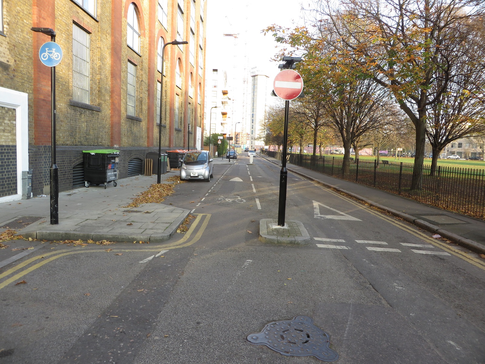
On the opposite side of New North Road the cycle contraflow has been removed on Poole Street to allow the road to become two way for motor vehicles


I'm not quite sure why this has been done. Under the original plans this was needed so motor vehicles could exit the parking and loading bays but under the revised plans motor traffic can still exit Poole Street onto New North Road. Surely the best intervention would have been to keep the road one way for motor traffic and then move the loading and parking bays further out to create a cycle lane behind the parking; there was certainly enough room to do this


and people wouldn't have to cycle between lorries 


A major flaw with the new design is that every time I have been here all traffic on Poole Street is turning right to travel north on New North Road, because if you wanted to travel south you would likely do so further back by driving south on the busy Pitfield "cycle superhighway" Street. However as traffic on Eagle Wharf Road is banned from making a right turn all traffic on Poole Street has to wait to give way to traffic coming out of Eagle Wharf Road. This can often be around a dozen vehicles which means motorists have to wait the entire cycle of the green light to turn right, quite often eventually doing so on a red signal. As I was stood here recently the black van pictured below took exception to having to wait for his third cycle of green light and instead overtook several cars to drive through the red light, nearly causing a collision


I've also noticed that nearly every time I have cycled this way I cannot use the ASL as there is a motor vehicle sat in it. I think that this isn't cars driving into the ASL on a red but rather that they are stationary there as the lights switch back to red


These traffic lights would work fine if the junction was cycles only but under these revised plans this is a serious design issue.

On New North Road itself I was surprised that on this very wide three lane road, used by over 20,000 motor vehicles per day, the plan in the original consultation was to simply paint a wide central hatching to replace the central lane when there was clearly the space to provide cycle lanes


However this did not occur in the final plans and instead the road is left with two very wide lanes, leading to high speed of motor traffic on this 20mph road


If you're cycling south on New North Road and want to turn right onto the cycle grid to cycle into Central London, as many people here do, then the original plan for the cycle waiting area in the middle of the road has also been dropped. This means you now wait in the middle of a very wide road with cars driving directly towards you, as they prepare to get into the right filter lane directly after this junction to turn into Baring Street. It is a really dangerous layout and best described in this forum post.

I'm afraid Phillip Glanville, the Mayor of Hackney, is wrong when he says these designs are "a far better more liveable set of crossings, junctions and filtering". The signals do make it safer to cross New North Road at this junction but the situation on both Poole Street and New North Road is worse with the protected cycle infrastructure removed and cycling on New North Road is now far worse than it was. A real missed opportunity to create safer cycling conditions, suitable for all.