Monday, 26 August 2019

Going Dutch in Hackney Central

The very northern section of Mare Street is Hackney Centrals high street, known as the Narroway. A Narrow street along most of its length (hence the name) it was part of the Hackney Central one way system until the 1980s but remained one way (southbound) when the gyratory was removed but only to be used by local buses, people cycling and deliveries. This made it unpleasant to walk on, due to narrow footways, and was an obstacle for people cycling, who could only do so in one direction and so faced a lengthy diversion. Although many would still cycle the wrong way, often on the pavement, causing further issues for people walking. Ten bus routes served this street but the bus stop at the southern end of the street could only accommodate a couple of buses so any delays in passengers loading, unloading or paying (in the pre contactless and oyster days) could result in a long line of stationary buses queueing along this street. I'm not exaggerating by stating that on some days it took me ten minutes to get from the top of the street down to the bottom on a bus; a distance of less than a quarter of a kilometre.

The pedestrianisation of the Narroway was an obvious improvement for both pedestrians and bus journey times so in June 2013 all buses were removed from the Narroway and diverted to use the same route northbound buses used; via Dalston Lane and Amhurst Road. Cycling was also permitted along the street in both directions but in order to prevent cyclists from "owning" the roadspace it was redesigned to ensure it was clear this was "shared space"

A photo I took of the Narroway in 2013, shortly after the buses had been removed, you can see how narrow the pavements were, with the space on the right a loading bay for deliveries 
Image taken from the architecture practice who designed the temporary layout
Hackney conservative councillors came from their wards in the north of the borough to protest alongside local traders who feared removing the buses would result in a loss of trade, however following a six month trial the scheme was deemed to be a success and a bid was made to TfL for funding for a permanent  redesign of the street. A consultation took place in late 2015 where 90% of people responded supported the plans, with only 6% against them.

A total of 8% of respondents to the consultation expressed concern at the risk of conflict between people walking and cycling in the new layout, this was the highest concern of all responses. Hackney Council claimed in late 2015 that there had been no reported collisions between people cycling and walking since the start of the trial in 2013. I really want to thank Hackney Council for making the sensible decision to allow cycling on the Narroway and taking an evidence based approach to this decision

A high street in Northampton, typical of many pedestrianised high streets in the UK that do not allow cycling. Since I took this picture part of this street has had the pedestrianisation removed to allow motor vehicles to return 
I've cycled on many shopping streets in the Netherlands which, like the new Narroway in Hackney, are signposted as pedestrian zones with cycling allowed, and have never found conflict between people walking and cycling to be an issue

Nijmegen 
Although I have noticed that these motor traffic free streets will sometimes have the markings of a road and footway on them, to indicate roughly where people can expect bicycles or service vehicles to be (although people can, and do, walk anywhere they like on the street)

Zwolle

The Narroway was also initially planned to have a similar layout, to reduce conflict between people walking and cycling
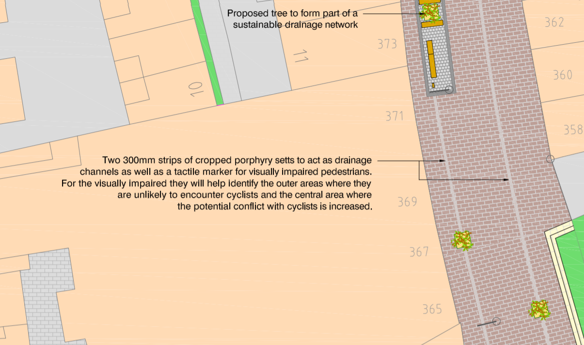

However the Royal National Institute of Blind people stated that they did not support the tactile strips, instead calling for detectable kerbs to separate the "cycle lane from the footway". The council agreed to remove these strips and any features that may resemble cycle lanes from the scheme, with the road designated a "Pedestrian Zone" which allowed considerate cycling. The scheme was budgeted at £3.25m, with nearly £2m supplied by TfL, just over £1m from the council and the rest via S106 agreements. Reconstruction began in January 2017 and was meant to last for a year but hit delays and took until late 2018 before it was fully completed

Reconstruction underway in 2017
The Northbound street remains no entry for all vehicles, except cycles


Southbound the street is signed as a pedestrian and cycle only zone, except for loading between 6pm and 10am. There are no loading bays marked on the street with local retailers asked to observe considerate parking when loading

Entering the street Southbound 
New seating, trees and additional cycle parking has been added


The cycle parking is well used, although I'm not personally keen on the steel designs and would have preferred traditional cycle stands 


Catenary lights have been used, suspended from wires attached to the buildings either side of the street to avoid the need to use poles 

Catenary wire systems are also often seen in the Netherlands to hold lights and tram wires on main roads in cities, leaving more space on the carriageway for cycling infrastructure 

It's a really lovely street to walk, cycle and sit to have lunch on now, much improved from the bus clogged place it used to be, and certainly a huge upgrade from the gyratory days of the 1970s! 

The Narroway in 1975 and 2019 
At the top of the street the original plan was to have an uncontrolled crossing over Dalston Lane / Lower Clapton Road, which seems like an odd decision considering how busy the road is. During construction this plan was changed and thankfully a wide signalled crossing was installed instead


although this meant that it was illegal for people cycling to use this crossing, although there was really no other choice. Thankfully within a few months this was changed and the crossing became a toucan crossing


The new toucan crossing allows people to cycle onto the footway on the other side and then up Clarence Road, which is a fairly quiet road to cycle on, due to all streets to the west of it filtered to through motor traffic at Pembury Road and a left turn only onto Lower Clapton Road, forcing drivers coming from the top of Clarence Road or from Lower Clapton Road back in the direction they have just come from. This means that Clarence Road is not a useful through route for cars and only really serves as an access road to the streets leading off it. It does however serve as a popular cycling route from Hackney Downs to the Narroway due to its directness and quietness.


Unfortunately it is still illegal to cycle up Clarence Road from the Narroway, as a clear "no entry " sign demonstrates. The plan outlined in the consultation was for a "No entry except cyclists" sign to replace it but nearly three years on from the beginning of the scheme construction and a year after it was completed this has still not yet happened for some reason. There are also no signs to indicate the pavement at the bottom of Clarence Road is shared but surely as it is a toucan crossing it must be. Perhaps a short bidirectional cycle track from Clarence Road to the crossing and a clearly marked bicycle and pedestrian crossing, as there is on Hackney road at Columbia road, might have been better.


The wide toucan crossing is a vast improvement on the staggered crossing that it replaced, however the new central strip on Dalston Lane forces cyclists into primary position on a very busy road and one of Hackneys busiest bus routes. The space here could have been used for protected cycle tracks instead.

Dalston Lane has changed a lot in recent years, due to the Pembury Circus / Atkins Square development on the north side of the road, which has delivered over 200 new homes, a new supermarket, a cafe and a community centre, where the Hackney cycling campaign hold their monthly meetings. As part of this development the footway was extended and is now gigantic all the way from Pembury Circus to the Narroway


A rather wasteful use of the space available when right alongside people are expected to cycle on a narrow road either in the doorzone of parked cars or on a very badly surfaced road. This road is used by over a hundred buses an hour at peak times and over 10,000 motor vehicles everyday which means families in the new development have no safe way to cycle to the Narroway, although in reality most will simply cycle on the huge footway instead.

Five years on from Hackney Council declaring that they want their roads to be the safest roads for cycling in the UK, where it is second nature for anyone, no matter what their age to cycle. Dalston Lane certainly isn't somewhere where that can happen

A better use of the space would have been a bidirectional cycleway linking Pembury Circus with the Narroway, whilst still leaving ample space for pedestrians, trees and street furniture

It's better to make the roads safer for everyone 
Whilst the Narroway does have a safe route leading to it from the north, via Clarence Road, the same cannot be said about accessing it from the south (unless you count an awkward and indirect route through St. Johns Churchyard from Q2 at Churchwell Path). The vast majority of people cycling on the Narroway will want to get to and from the Hackney Grove cycleway that leads to London Fields and you really only have one option; to brave cycling on Mare Street. Cycling towards the Town Hall you'll almost certainly first meet a wall of buses and other motor vehicles at a red light at the Graham Road junction, with no ASL and no way to filter through


Once through the green light you'll then have to manoeuvre across into the second lane as the lane you're in is for left turning traffic only. Often this will involve using lane one until you get to the lights at Morning Lane, only to then try and swing right into the ASL, assuming it isn't blocked. I've downloaded a couple of TfL traffic camera clips from one recent morning rush hour below to show a typical example of this


It may not surprise you the hear I've never once seen a child cycling to school at during the rush hour here!

The traffic lights are on red at the Mare Street / Morning Lane junction as I took this photo. The ASL is almost completely blocked by a bus and two cars. Would you filter through that queue of cars and lorries with your family on bikes here?
Once you get a green light on Morning Lane you either choose to swing back to the left again to allow traffic to pass or, knowing you're about to turn right onto Reading Lane to get to the cycleway leading to London Fields, stay on the right of the lane in the middle of the carriageway and have motor traffic passing you on both sides until you "take the lane" at the pinchpoint to use the right turn filter.


Cycling south from Reading Lane to the Narroway isn't much better, or possibly even worse. If you scroll up to the top of this page you'll see my header image is a picture of this road, a shared bus lane on a road six lanes wide. Once though the Morning Lane lights you can then use the left hand lane to go ahead, rather than being forced to manoeuvre into lane two, but often you're either sandwiched between traffic or will have to brave it and filter through


Before you get to the Narroway where you want to turn right into it


If you're lucky the pedestrian crossing will be on red round the corner, giving you a clear chance to do so. Often though it won't so you either block the road waiting to turn right, and get honked at, or wait in the middle of the road with buses passing close by on both sides of you


Cycling through Hackney Central is for the brave few, and certainly not for the many. Last week I saw this family cycling along the fantastic new Narroway, perfectly safe and chatting away with each other


To be fair to them, when they got to the bottom of the Narroway they waited and then carefully made their way up Mare Street cycling in the carriageway. Then they got to Graham Road and a wall of motor traffic greeted them where they, understandably, crossed over the pedestrian crossing and continued up to the Hackney Grove cycleway by cycling considerately on the pavement. Who can blame them? Cycling with your family on the road here is frankly not safe and I would never do it.


The other issue is that Mare Street is also a destination for families, with the Picturehouse cinema holding family screenings at the weekend and the Hackney Empire regularly often featuring shows for children. It makes sense for some local families to arrive here by bike but they are really left with little option but to use the pavement


Give these families a safe route through Hackney Central and they won't be cycling on the pavement. The present layout is simply not safe enough and is one of the worst locations for cycling collisions in the borough


It was very disappointing that a few years ago the local police announced that pavement cycling was the priority crime that they would be dealing with


Yes, pavement cycling is annoying but lets focus on the real danger here, which is people walking and cycling being inured or killed by motor traffic.

A pavement on Mare Street in Hackney Central. Is pavement cycling really the issue here?

If you want to stop people cycling on the pavement in Hackney Central then providing safe conditions for them to cycle is the clear solution. This solution was presented to Hackney Council back in 2015 when Andrew Gillian was the cycling commissioner and Quietway 2 was planned to go via the most obvious route, linking the Hackney Grove cycleway and the Narroway

Option 1 - a bidirectional cycle track running along the western side of Mare Street, linking Reading Lane with the Narroway and finally making Hackney Central a place that is safe enough for anyone to navigate on a bike. Option 2 was stepped cycle tracks running on either side of the road
Hackney Council had the funding, plans and support to go ahead with this years ago but instead chose an indirect and unsafe, busy back street route instead

Hackney Council in their 2015-2025 cycling plan 

The future of Hackney Central - have your say

Two years ago Hackney Council received £10m in funding to finally introduce protected cycle tracks on Mare Street in Hackney Central, redesign the Pembury Junction and make Amhurst Road, which runs between the two, a through route for buses only.

Amhurst Road is already four lanes wide so with a bus gate protected cycle tracks can easily be accommodated. Bus priority is achieved without the need for bus lanes, because the private motor traffic will have been removed 
Hackney Council are inviting you to have your say on these improvements. Obviously protected cycle tracks running the length of Mare Street though Hackney Central will be required as that is what the TfL funding is for. Any reversal of this proposal with an attempt to force people cycling in with buses would have to result in the funding being withdrawn and given to other councils who are enabled the necessary changes to ensure their roads safer for everyone.

As well as submitting your comments on moving through Hackney Central you can also add comments to a map, which covers a wider area. Perhaps you'd like to see Chatham Place filtered on Q2 or modal filters on the Naverino Road cycle route? Perhaps the contraflow cycle track on Paragon Road should be made bi-directional and run all the way from Mare Street to Morning Lane to link the proposed cycle tracks on Mare Street with the recently constructed cycle track on Wick Road?


If you live, work, shop or travel through Hackney Central then please do let the council know what changes you'd like to see to the roads and junctions that would enable families to get about by bike and ensures that the safety of people walking and cycling comes first.

Monday, 25 March 2019

The new Isle of Dogs to Hackney cycle route

Transport for London are currently asking for views on proposals for four new cycle routes in London. One of these is a 7.5km route from the Isle of Dogs to Hackney via Westferry, Mile End and Victoria Park. The route through Tower Hamlets has already been decided on, running from Canary Wharf on a direct main road, via West India Dock Road, Burdett Road and Grove Road. Once the route exits the borough of Tower Hamlets and enters Hackney there is a choice of two routes, which TfL want to hear your views on. One proposed route continues on the main road as Grove road turns into Lauriston road, whilst the other route turns off the main road to run on residential streets, via Gore road along the northern edge of Victoria Park


Lauriston road runs through Victoria Park Village and I regard it as my local High Street. In Hackney Wick we have only a handful of local shops and so need to travel out of the area for most purchases. Westfield shopping centre in Stratford is an obvious choice and is one I do use a fair amount due to the convenience (although I find myself going there less these days since the upgrade of Westfield Avenue and removal of all cycle parking). Roman Road in the neighbouring borough of Tower Hamlets is closer than Lauriston Road but requires cycling on narrow busy roads which I prefer to avoid, especially if I'm cycling with my young daughter. Lauriston Road however, is a quick cycle ride though the pleasant Victoria Park. For the last three Christmases I have exclusively used Lauriston Road for my Christmas day shopping - meat from Ginger Pig, wine from bottle aspotle, vegetables from Village Organic and cheese from the deli downstairs. I'm a regular visitor to all of these shops all year of course, and any time we're off to yet another children's birthday party then the Toybox, a small independent toy shop that gift wraps for you, is a blessing. There are other shops and restaurants I could mention that make Victoria Park Village such a pleasant place to visit. However the road layout is certainly not one of them and this proposed route could be a great opportunity to make Victoria Park Village a much nicer place for those visiting on foot and by bike

Almost every time I am i this area I see people cycling on the pavement, usually young children and families. I've spent some time walking along this road taking photos over the past week and even I was surprised at just how much pavement cycling by families happens here. All photos used in this blog have been taken within the past week.

As Grove Road exits Tower Hamlets and turns into Lauriston road in Hackney the road has a very cycle-unfriendly road surface, consisting of uneven stone setts. This was installed during the upgrade of Victoria Park prior to the 2012 Olympic Games and designed to slow down traffic. Ideally this should be replaced with a smoother surface and, ideally, a tiger crossing to link the two parks, rather than cyclists having to hop on and off the pavement to use the zebra crossing.


The current road surface is too difficult to use for those with young children on small bikes 
Gore Road is a wide street which results in long crossing distances for pedestrians and is also a busy road with lots of motor traffic coming in and out of it

Even the Google maps streetview car caught a driver parked on the dropped kerb on the corner (a regular occurrence) as a parent tried to cross with their bike,


Directly opposite is Wetherall Road, a busy route for cyclists at night who want to use the shared footpath on Victoria Park Road when the Park is closed, as well as for children going to Mossbourne Victoria Park Academy School. Cycleway or no new cycleway both of these roads should be narrowed at this junction and filtered to reduce or eliminate through traffic using them as a rat run


As you enter Lauriston Road from Grove Road its noticeable just how wide the road here is, with an exceptionally wide carrigeway, you could fit about six lanes of traffic here and still have space left over for parking on both sides of the road!


There is clearly ample space here for protected cycle tracks, with floating bus stops with plenty of room left over for a narrower roadway, and to retain parking and loading.

Before and after in Nijmegen: a wide road with painted cycle lanes in the doorzone is narrowed to create protected cycle tracks and a central divider to keep motor traffic speeds low. Continuous footways and added greenery improve the road layout for pedestrians as well as cyclists 
The road surface here is also in a terrible condition and is particularly dangerous if you're on a bicycle as you either stay in the door zone or are forced to cycle in the middle of the road to avoid the poor surfacing


Morpeth Road, which should be a quiet residential street but is actually a heavily used rat run, has two exits onto Lauriston Road along with narrow pavements with pedestrians constantly having to give way to cars coming in an out


It's obviously been good to see so many children and parents going to and from school by bike this week but all of them, without exception, were cycling on the pavement, rather than on the road


This was also the case last weekend with families on bikes shopping or going to and from Victoria Park


the cycle parking outside the shops is very well used and I can tell you from personal experience that it's a regular occurrence to not be able to park a bike at any of the cycle stands


I've always thought most of the grass here could make way for a protected cycle track, with the bike parking moved closer to the road between the trees. This would ensure the cycle track is close to the shops and create more space for pedestrians.

Easily the space for a cycle track, trees and a much wider footway on Lauriston Road
The cycle track could then continue alongside the trees, which also means it would be set back some distance from the bus stop


freeing up carriageway space for a cycle track on the opposite side of the road, along with loading and car parking spaces


Saying that, parking is free on this road, except for two hours between 10am and midday Monday to Friday only. At the weekend it was clear that an awful lot of cars were being parked here so parents could take their children to Victoria Park so not sure how having cars parked all day for free is good for trade of local businesses along here. With a network of protected cycle tracks and filtered residential streets many families could easily cycle here from the surrounding area

Before and after in Amsterdam - car parking removed from what is already a quiet residential street to create a cycle track for a safer and more direct route out of Vondelpark so families can safely cycle to and from the park 


Ruthven Street is a minor residential cul-de-sac which leads to no more than a dozen houses and even fewer car parking spaces. However it is two lanes wide and you often see motor vehicles parked here, usually on double yellows at the edge of the road but sometimes also blocking the dropped kerb


A continuous footway and cycle track, with street furniture located at the edge of a narrower access would prevent this and improve the situation for people walking and cycling


Just north of here Lauriston Road meets Victoria Park Road at a roundabout where Shivon Watson was killed under a lorry whilst cycling here almost exactly nine years ago. The council removed her ghost bike many years ago but a single flower remains at the scene

Note the mum and her child cycling on the zebra crossing in the background. Would you cycle with your children on this roundabout or would you stick to the crossings? 

Victoria Park Road is a horrible road to cycle on; filled with lorries and coaches using it to drive from the A12 into Central London. Nearly 12,000 motor vehicles use it everyday with 93% of them breaking the speed limit. People cycling should not be expected to share with lorries and buses on a roundabout like this and it's frankly disgraceful that nine years on from Shivon Watsons death no changes have occurred here. The proposed route in this consultation is a wonderful opportunity to finally fix this deathtrap, which makes it all the more bizarre the backstreet route is even being considered.

With a slight reduction in the size of the (very pretty) centre of the roundabout this junction could accommodate cycle tracks and cyclist priority alongside the pedestrian zebra crossing

North of Victoria Park Road at Southborough Road and the vast majority of carriageway space is reserved for car parking, meaning very long crossing points between footways for pedestrians

Does this road layout put pedestrians and cyclists at the top of the road user hierarchy, with cars at the bottom? 


Whilst I'm not against some cycle routes running along quieter roads; for example the route from Hackney Central to Hackney Road runs along Goldsmith's Row and Broadway Market, which is a shorter and more pleasant route than Mare Street. However in South Hackney the proposed back street route would be a mistake, it should quite clearly be much more beneficial to run along protected cycle tracks along Lauriston road instead to serve the shops, houses and schools along here, whilst committing to filtering more residential streets in the surrounding area. The eastern alignment would link Victoria Park with the shops in the village, on Well Street, Quietway 2 and even the new cycle tracks on Wick Road. What a lasting tribute to Shivon Watson it would be to see families safely cycling on protected cycle tracks at the spot where she was killed riding her bike

Transport for London state that the route options are not decided and that they will be refined based on comments and feedback. You can email them via newcycleroutes@tfl.gov.uk with ideas, comments and suggestions up until 31st March. If you live in or visit the Victoria Park area and would like Lauriston Road to be improved for people walking and cycling then please do respond.