Showing posts with label Islington. Show all posts

Thursday, 17 October 2019

The stonewashing of Worship Street

Worship Street, despite being less than half-a-kilometre long, runs through the boroughs of Islington, Hackney and the City of London. It has been in existence for centuries and is clearly visible in the same location on a 500 year old Tudor map of London, although surrounded by fields, rather than offices as it is today.  As Worship street crosses over from Islington into Hackney it dissects Cycle Superhighway 1 in two with people cycling on CS1 having to give way to motor traffic on Worship Street in order to cycle into the City

Worship Street, where it crosses Paul Street & Wilson Street (Cycle Superhighway 1)
As is clear from the photo above it can be a busy street at times making it difficult for people cycling on CS1 to cross, as many motor vehicles use it as a main route between the Ring Road at Great Eastern Street and City Road, rather than continue on the ring road via the Old Street Roundabout

Worship Street, highlighted in green

You'll note that all traffic using this route has to technically "turn" either right or left and use Curtain road. Whilst Worship Street runs east to west between City Road and Shoreditch High Street (as it has done for over 500 years), motor vehicles have been prohibited from using this direct route for over 25 years. This is due to the IRA Bishopsgate Bombing which resulted in a huge security cordon being placed around the City; initially policemen with traffic cones around the financial district and then a more permanent solution, with nearly 50 streets at the edge of the city sealed off with bollards, leaving them inaccessible for motor traffic but still open for people walking or cycling.

This is how Worship Street looked at the vehicle closure point at the beginning of this year, with a photo I took on New Years Day:

Photo taken from Appold Street in the City of London, looking at Worship Street and Curtain Road, in Hackney 
As you can see there is a narrow through route for bicycles and this is a route I use on a fairly regular basis, if I am cycling on CS1 from dropping my daughter off at school and going to my workplace on the other side of Liverpool Street. Although very quiet in the New Years Day picture above that is not the case at peak time in the morning and you often have to stop and give way to other bicycles, as well as mopeds, coming from the other direction. Worship Street is also generally an unpleasant route to cycle on at peak times as it is very busy with vans, lorries and taxis using it and the road surface is in a terrible state, filled with potholes and sinking manhole covers. Despite using this route dozens of times to cycle from CS1 into the city I didn't notice until I was here on foot on New Years Day that there is also another cycle route on the opposite side of the bollards


This cut through is only really worthwhile if you're coming down from Curtain Road and turning left into Worship Street to head towards Bishopsgate, hence why most people use the other route in both directions instead. You may also notice how the cycleway in the picture above is even narrower, barely wide enough to fit a bike tire in it. This is due to the construction of Principal Place, a newly opened 15 storey office block alongside, built between 2015 and 2018 on long empty land between Curtain Road and Shoreditch High Street, where the disused viaducts into Broad Street station stood until 2014. It also has an enormous 50 storey residential tower alongside it, next to Shoreditch High Street (where over a dozen flats are on the market in excess of £5 million). As part of the planning permission the developers had to contribute various sums to invest in local infrastructure; £10m to Crossrail, £4m for off site affordable housing and various amounts to Hackney Council; from £198k for libraries, £240k for local education and £850k for Highways improvements.

At the beginning of the year Hackney Council decided to invest some of that Highways money to refurbish the area outside, removing the bollards and island in February:


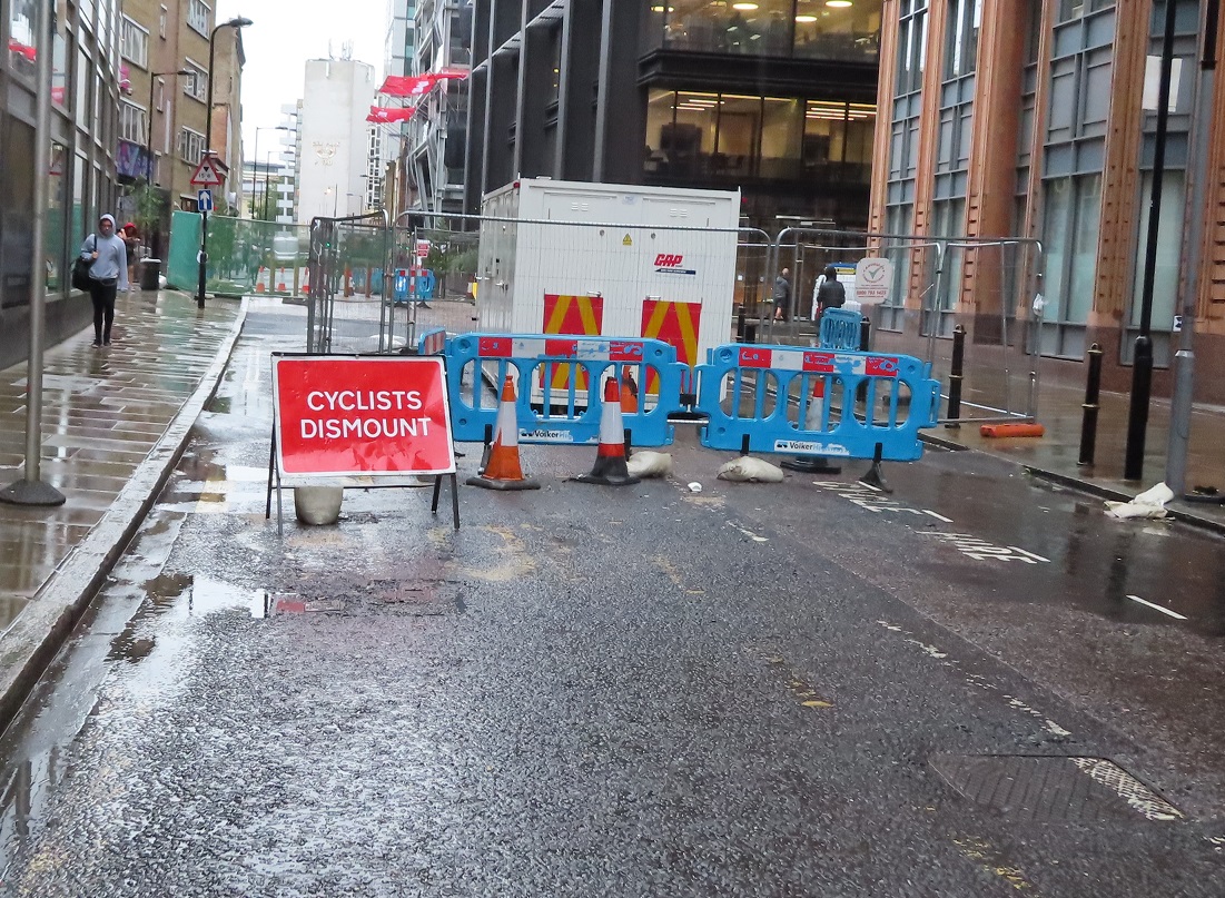
It was a little disappointing to see cyclists dismount signs, considering these were signed as Hackney Council works and there was still a clear route available for people on bikes.


Towards the end of February Worship Street and Curtain Road were closed to motor vehicles altogether either side of the works. A route was kept open through the middle of the works for people walking or cycling


A few days later the "cyclists dismount" sign reappeared even thought the route was signed as "cycle access only" just beyond it.


People continued to cycle through the works and it worked well as a temporary shared route for people walking and cycling, although mopeds were also still using it, which didn't work so well, leading to local police taking action

The following day the "cycle access only" sign was removed and replaced with another cyclists dismount sign. Again, a little disappointing from Hackney Council


By late April Worship Street and Curtain Road had been closed for two months and I'd got used to the quietness. Local businesses seemed unaffected; deliveries were being made by motor traffic either side of the closure whilst the street was filled with the sound of people chatting as they walked; a huge improvement on the motor dominated street it was at the beginning of the year.. There was also an added benefit for people cycling nearby on CS1 - with no through traffic on Worship Street crossing the road became much easier

Three months on from the closure and a sign appeared on Appold Street to say it would be "closed from 20th May for six weeks"


By early June most of the street works seemed to have been completed, but both roads remained closed with cyclists dismount signs on all approaches


In the middle of July Worship street reopened to motor traffic, having been closed as a through route for six months by that point

A street used only by people on foot or bike for six months, Worship Street returns to a street filled with motor traffic using it as a was to avoid the Inner Ring Road
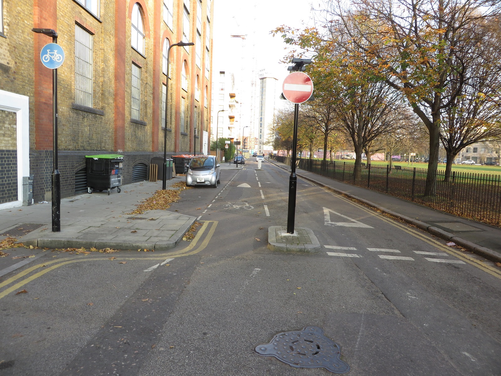
Appold Street remained closed, with cyclists dismount signs still there, for what appeared to be just a toilet parking spot. There was easily the space to allow a cycle route past here


The signs didn't stop the many mopeds from continuing to use this route


By August Appold street was still shut, with the sign at the beginning of the street stating that the closure was in place for "six weeks from May 20th", although the closure had been in place for over three months by that point. As there was actually very little sign of any work taking place I assumed this was due to the wide gaps either side of the new bollards where a motor vehicle could drive through with ease, therefore bypassing the entire ring of steel and driving into the city completely undetected


However at the beginning of September Appold Street finally reopened after four months, with the large gaps either side of the bollards intact, debunking my theory altogether


The bollards were very close together making them a tight fit, I could only just get through with the crate on my front bike so I'm not sure a cargo bike would be able to, although motorbikes could - just about


Then a month later the workmen returned to remove one of the bollards and reconfigure them, to allow slightly larger gaps to cycle through. New bollards were also placed on the footway to plug the gaps

Six bollards became five bollards about a month after work here was completed. Still too narrow for the man on the cargo bike with boxes, who opts for the pavement instead 
Some changes have occurred to Appold and worship Street within the city of London - firstly Worship Street has been resurfaced from Shoreditch High Street and had the contraflow cycle lane painted all the way along it.


Previously you could contraflow cycle along this one way street (for motor traffic) but then have to navigate around a bus stand into oncoming traffic! The contraflow cycle lane continues around the corner to (almost) Primrose Street. The cycle hire stand has also been moved around the corner to accommodate this (although annoyingly the road has not been resurfaced and the former electrical points for the cycle hire stand remain as a line of badly sealed up holes in the tarmac)


Another peeve is that the cycle lane is just a painted lane so naturally I've seen delivery vans parked in it. A kerb protected cycle lane would have been better. It also stops just before the traffic lights at Primrose Street where a "normal" junction with ASL remains, despite this only being accessible by bike (although I've seen black cabs drop off and U-turn here, which could well still be legal)


Despite the cost and time taken for this upgrade Worship Street has not been resurfaced either side of the fancy new paving area, and remains in a terrible state


As for the new paved area of Worship Street, this is the very definition of a stonewashed street


The nearby Leonard Circus has a similar design and looked as good as this on day one but soon had damaged street furniture, now a constant sight

I think these tree cages must have been replaced at least five times each by now
It appears as though some of the street furniture has already been hit on Worship Street, not that anyone particularly wants to sit and eat lunch inches from a lorry tyre! 


It is a real shame that Worship Street was not permanently closed to through motor traffic as part of these works. It was closed for six months and didn't seem to have too much of a drastic effect on surrounding roads. I cycled through and around the closure many times in that period and there was no gridlock or carnage on surrounding streets. A walking and cycling only street, with more trees and benches and an easier crossing on CS1, would have made this a much nicer area than some fancy paving under lorries that should really be using main roads nearby instead.

Thursday, 8 February 2018

The Improved Central London cycle grid in Hoxton

In late 2016 Hackney Council consulted on improving a section of the Central London cycle grid in Hoxton, and I wrote about it here whilst the consultation was still open. This section of road was historically known as LCN+ route 16 but is now referred to as the Central London Grid, which forms part of the 'wider quietway route'.

The Central London Grid is a matrix of safe, connected quietway routes and is aimed at new cyclists and people who like to cycle away from heavily trafficked roads. The CLG network will provide continuous and connected routes for cyclists linking key destinations. The intention of the CLG quietway routes is that they will follow direct back-street routes, through parks, along waterways or tree-lined streets. The routes will overcome barriers to cycling, targeting less confident cyclists who want to use low-traffic routes, while also providing for existing cyclists who want to travel at a gentler pace.

These cycling improvements were fully funded by TFL, at a cost of £640,000, as part of the Mayor of London's vision for cycling in London programme but were designed and implemented by Hackney Council.


The main change on the quietway itself was the redevelopment of the crossroads where the quietway crosses New North Road. Previously you had to try and cross the main road with no assistance, although there was a pedestrian crossing around 30 metres south of this junction which did assist a little. The original consultation proposed to close both Poole Street and Eagle Wharf Road to motor traffic and then to install four pedestrian crossings at the crossroads, removing the one further south.


Whilst this proposal was a definite improvement it was clear on the plans that there was to be no physical closures of these roads, just "no entry" and "cycles only" signs. I suggested in this blog, and in my consultation response, that a physical closure of the carriageway should be implemented with entry maintained for cyclists, similar to this:


Which would allow a tiger crossing to be constructed instead


The Hackney cycling campaign also suggested physical closures of the two quietway roads at this junction. The response from Hackney Council to this suggestion was that

"The use of physical barriers to stop motorised traffic gaining access onto Poole Street and Eagle Wharf Road is not desirable as it can cause delays for emergency services in the event of an emergency"

However also part of these plans was to close Sturt Street to motor traffic, just around the corner. The London Fire Brigade responded to the consultation with concerns the barrier at Sturt Street would be an impediment for emergency services and the response from the council was that

"The road closure at Sturt Street will be implemented using fixed and lockable barriers that allow access for emergency vehicles and cyclists when required" 

Which is what has occurred, so I'm unsure why this was viable to do here but not at the New North Road junction. 


the newly filtered Sturt Street
However the proposed closure of these roads did not happen, as the council explain

"The London borough of Islington was consulted before the consultation document was distributed. After the consultation period the Lead Member for the London Borough of Islington submitted a formal objection to the proposals with concerns on the impact of rerouting traffic from Poole Street to Baring Street. A solution that does not negatively the London Borough of Islington road network was reached. A 'right turn' ban will be introduced at Eagle Wharf Road to allow left turning to gain access onto New North Road while left and right turning vehicular traffic will be able to come out of but not into Poole Street"

So, the layout remains almost exactly the same as it was and, crucially, the plans to close these two roads to vehicular traffic have been dropped. This means that motor traffic can, and will, continue to use Shepherdess Walk and Eagle Wharf Road as a shortcut from City Road and to the east of this junction car drivers can use the "quietway" as a route all the way from Hackney Road through to New North Road via the terrible lorry rat run Whiston Road quietway, which I have also written about previously here

It was pleasant to use this route whilst the works were taking place as the road was closed


The kerb has now been removed and replaced with a painted cycle lane, as can be seen in these 'before and after' pictures:


Additional car parking has been created and cars will have to drive over the cycle lane to get to it. The pavement has also been reduced in size to accommodate the additional car parking, paid for from the vision for cycling budget


But Eagle Wharf Road remains open for lorries to use as a shortcut from City Road


so, unsurprisingly, children prefer to use the pavement rather than mix with lorries


On the opposite side of New North Road the cycle contraflow has been removed on Poole Street to allow the road to become two way for motor vehicles


I'm not quite sure why this has been done. Under the original plans this was needed so motor vehicles could exit the parking and loading bays but under the revised plans motor traffic can still exit Poole Street onto New North Road. Surely the best intervention would have been to keep the road one way for motor traffic and then move the loading and parking bays further out to create a cycle lane behind the parking; there was certainly enough room to do this


and people wouldn't have to cycle between lorries 


A major flaw with the new design is that every time I have been here all traffic on Poole Street is turning right to travel north on New North Road, because if you wanted to travel south you would likely do so further back by driving south on the busy Pitfield "cycle superhighway" Street. However as traffic on Eagle Wharf Road is banned from making a right turn all traffic on Poole Street has to wait to give way to traffic coming out of Eagle Wharf Road. This can often be around a dozen vehicles which means motorists have to wait the entire cycle of the green light to turn right, quite often eventually doing so on a red signal. As I was stood here recently the black van pictured below took exception to having to wait for his third cycle of green light and instead overtook several cars to drive through the red light, nearly causing a collision


I've also noticed that nearly every time I have cycled this way I cannot use the ASL as there is a motor vehicle sat in it. I think that this isn't cars driving into the ASL on a red but rather that they are stationary there as the lights switch back to red


These traffic lights would work fine if the junction was cycles only but under these revised plans this is a serious design issue.

On New North Road itself I was surprised that on this very wide three lane road, used by over 20,000 motor vehicles per day, the plan in the original consultation was to simply paint a wide central hatching to replace the central lane when there was clearly the space to provide cycle lanes


However this did not occur in the final plans and instead the road is left with two very wide lanes, leading to high speed of motor traffic on this 20mph road


If you're cycling south on New North Road and want to turn right onto the cycle grid to cycle into Central London, as many people here do, then the original plan for the cycle waiting area in the middle of the road has also been dropped. This means you now wait in the middle of a very wide road with cars driving directly towards you, as they prepare to get into the right filter lane directly after this junction to turn into Baring Street. It is a really dangerous layout and best described in this forum post.

I'm afraid Phillip Glanville, the Mayor of Hackney, is wrong when he says these designs are "a far better more liveable set of crossings, junctions and filtering". The signals do make it safer to cross New North Road at this junction but the situation on both Poole Street and New North Road is worse with the protected cycle infrastructure removed and cycling on New North Road is now far worse than it was. A real missed opportunity to create safer cycling conditions, suitable for all.