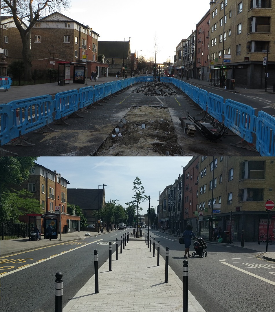
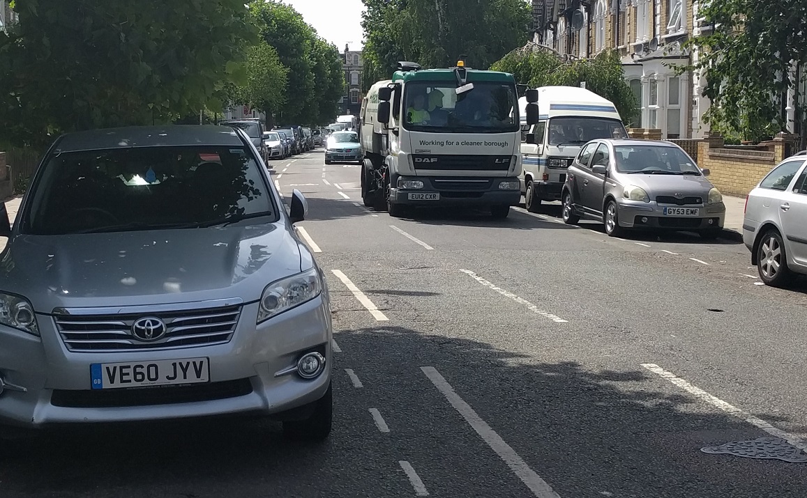
Quietway 2 is one of Transport For Londons flagship new "quietway" routes, running from Bloomsbury to Walthamstow.
"
Quietways are routes that will overcome barriers to cycling, targeting less confident cyclists who want to use quieter, low-traffic routes whilst also providing an environment for existing cyclists who want to travel at a more gentle pace. Each Quietway will provide a continuous route for cyclists, linking key destinations following backstreet routes, through parks, along waterways or tree-lined streets."
Part of Quietway 2 runs through Hackney and is nearing completion and so I cycled along it this week to have a look.
It begins at the border of Islington where Northchurch Road meets Southgate Road and no changes were made here due to the road already having a filter in place restricting through motor traffic

It is disappointing that no plans were considered to redesign this junction and remove the mini roundabout at this junction. Southgate Road is a busy road and I've had vehicles fail to give way to me here on a few occasions, not realising this is a four arm junction if you're on a bike.
I'm not anti-roundabouts,
far from it, but if this route is truly meant to be a high quality cycle route, specifically targeting less confident cyclists, then bicycles should have priority over motor traffic on Southgate Road and a much safer crossing.
 |
| A cycle route I used recently in Zoetermeer, the Netherlands; a similarly filtered road to Northchurch Road which has priority over the main road, with a cycle track on the main road as well. See this junction here on google street view |
The route continues on through De Beauvoir Town, again no changes were made here as these roads are accessible for motor traffic only by local residents or those visiting, the entire area having been closed to through motor traffic back in 1974, which
I've written about previously.
 |
| Filtered residential roads which make them safe enough for children to use. Picture courtesy of the Hackney cycling campaign |
 |
| The same location where the children are cycling above, before the road closures went in place |
Some minor changes have occurred outside St. Peters of De Beauvoir church where the filter has been rearranged allowing cyclists through the middle, rater than at the edge along a narrow strip. I'm unsure if this is part of Q2 or CS1 as these changes were made at the same time as the changes to De Beauvoir Road as part of the CS1 works, but I guess it all comes from the same "vision for cycling" budget at TFL and is carried out by the same contractors
Once through De Beauvoir Square the quietness abruptly ends as the route continues into Middleton Road, a road that is far too busy with motor traffic for it to be classed as a quietway. I've only cycled here once with my daughter and I don't think I will do so again. The only time that I've seen any children cycling here was when they on the pavement

This area was due to be filtered, in similar way to De Beauvoir Town on the other side of the A10 but after a consultation Hackney Council decided to only install width restrictions to keep out larger vehicles instead

It was a really terrible decision as this road is far too busy with through motor traffic that simply should not be here and a shame an 18 month trial to actually be able to monitor traffic and air quality impact was not carried out, as is now happening in the northern half of De Beauvoir Town. The route continues into London Fields along one of the East to West paths though the park. This path used to have a painted cycle lane on it but was removed several years ago when it was resurfaced; I wish they would repaint it to avoid pedestrian / cyclist conflicts, just as they have done recently on the main North to South path through the park.

Q2 turns left to use the painted cycle lane on the main path through the park and onto Martello Street. At the
Pub on the Park the vast majority of cyclists continue straight on towards Hackney Central, which is the quickest and shortest route to cycle north through Hackney towards Walthamstow and also where most of the main shops and other amenities lie. However Q2 turns right here down London Lane to the junction of Mare Street where this section of Quietway 2
was consulted on earlier this year. The original preferred proposal here was to close London Lane to all traffic except cyclists and in the consultation questionnaire 63% of respondents supported this road closure, the majority of whom were local residents. The council confirmed on 6th February that the closure of London Lane would go ahead due to the greater level of support and assured those residents on Ellingfort Road who had opposed the closure, due to displaced traffic using their road instead, that the closure and traffic impact would be monitored. Less than two months later the Council changed their mind and stated that after consultation with residents of Ellingfort Road and from developers constructing new developments in the area that they would amend the scheme and instead introduce a "point of no entry" on London Lane and a right turn ban on traffic exiting London Lane instead

This means that London Lane will continue to be a heavily used rat run as motor traffic uses Mentmore Terrace to avoid the sets of traffic lights on Mare Street (especially those coming from Westgate Street). If anything London Lane is now even more attractive rat run as it now has no oncoming traffic, except for people cycling. Meanwhile forcing construction traffic to run left onto Mare Street is surely dangerous when the intention of this scheme is for cyclists to continue straight on to use the refuge island in the middle of Mare Street. Surely the correct thing to do here would be to propose to close the road once construction work is completed and then filter Triangle Road (where a huge amount of traffic on Westgate Street uses it to by pass the Mare Street traffic lights) and then filter Mentmore Terrace outside London Field train station. This would ensure the entire area bounded by Westgate Street, London Fields, Richmond Road and Mare Street would be as quiet as the streets of De Beauvoir Town and benefit all local residents.
The original proposal for the central refuge island was, for some bizarre reason, to plant a tree right in the middle of it, making most of it unusable and forcing cyclists to use the bus stop or bus lane on Mare street before crossing over to the refuge
Thankfully these plans were amended and no 'CS1 Apex Crossing' style obstructions were placed in it
 |
| A wide central refuge, four wide lanes for motor traffic and wide pavements remain. It is quite clear to see how there is easily the space for protected cycle tracks along both sides of Mare Street |
The total amount given to Hackney Council by TFL from the vision for cycling budget for construction of this crossing of Mare Street was £255,000.
The route turns right into Loddiges Road and then down down Lyme Grove, which then becomes a shared alleyway and brings us to the junction of Brenthouse Road where this junction has been completely remodelled
If you're travelling towards London Fields it isn't really clear that you're meant to turn left down this alleyway, that bike sign painted on the road is the only indicator. I can see anyone unfamiliar with this area and trying to follow Q2 ending up cycling to the end of Brenthouse Road and having to use the bus lane where I was within centimetres of being hit by one of "London's finest" around a decade ago. At the end of the alleyway there are some high rumble strips intended to slow cycles down before the shared pavement but these are real bone shakers, even for myself on a large Dutch bike.

I think they would be too high and difficult for my five year old daughter to cycle over and
possibly a real disadvantage for disabled cyclists. Perhaps a clear cycle path, distinctive from the pavement, would have been a better solution here. This area is currently too busy with motor traffic to be classed as a quietway which is why I'm delighted to see
this current proposal from Hackney Council to reduce traffic in the area. Please do respond positively to the consultation.
Q2 continues along Chatham Place, which remains two way for all traffic and can be a tight squeeze if all car parking is in use.

Let's hope that further traffic reduction schemes are planned for this area and through traffic can also be removed on roads such as Chatham Place and Mead Place.
At the junction with Morning Lane a new tiger crossing
was consulted on this year allowing people cycling to cross safely into Churchwell Path. This was just an ordinary two-way side road junction before the quietway but now traffic cannot enter from Morning Lane and traffic exiting Morning Lane can only turn right. I must say I'm rather disappointed in how this has turned out.

Firstly notice how there is a "SLOW" sign for people cycling entering the junction but no slow signs for anyone driving. The ramp is also very steep whereas motorists get a longer ramp with a much smoother gradient up to the junction. Finally cyclists are on a "shared pavement" as they approach the crossing but on the road alongside for motor traffic the tarmac continues, giving the impression that motorists have priority over pedestrians. I am a big fan of continuous pavements and think they should be installed at every side road to make it clear that pedestrians have priority
 |
| An example of a continuous pavement in Amsterdam |
Either have a continuous pavement all the way across the junction or have the cycle lane continue after the tiger crossing and relocate the cycle stand, rather than having one approach for cars and another for bikes. Initially the layout was even worse with a bollard in the middle of the narrow ramp, rendering it useless for many wide cargo bikes.
 |
| Image courtesy of @bikesandbabies, the bollard was removed days after this photo appeared on twitter |
The total amount given to Hackney Council by TFL from the vision for cycling budget for construction of this crossing of Morning Lane was £130,000.
On Churchwell Path the painted cycle lane has been removed, making it shared space

Again in my view this is a mistake and may lead to conflict between people cycling and walking. Saying that the path narrows down considerably alongside the church and so the cycle lane would have to end to become a shared path there. The path is well used by pedestrians, especially during the morning rush, so perhaps this was not the correct location for a new major cycle route. At the end of the path there is a fiddly manoeuvre on a shared pavement past "street clutter" as I believe it is called.

Doesn't seem like it would have been a huge job to remove the pointless short wall and relocate the telephone box to create a clear path to the tiger crossing? This crossing
was consulted on exactly a year ago and is probably the best section of the entire route with the closure of the South East entrance to Clapton Square (with bendy bollards so emergency vehicles can still access) resulting in an almost traffic free route up the side of the square
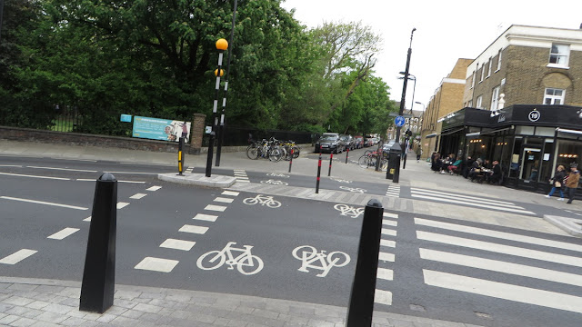
The total amount given to Hackney Council by TFL from the vision for cycling budget for construction of this crossing of Morning Lane was £180,000.
More rumble strips have been added to Clapton Passage (although you can cycle directly down the centre of the path to avoid these) before coming to Lower Clapton Road, a very busy road which carries around 14,000 motor vehicles per day. However I find it astonishing that the Quietway hasn't been used to create a crossing here. There is a zebra crossing just north of the junction (which some cyclists do use) but this means cycling on the pavement for a short distance and, according to the local police, drivers would
"effectively be right" not to stop for young children on bikes and run them over instead.
For those cycling west along Powerscroft Road to cross over Lower Clapton Road the contraflow cycle lane leads onto the pavement (assuming it isn't blocked)

where there is no assistance to help you cross into Clapton Passage across this very busy road. Hardly targeting less confident cyclists! No changes have been made to Powerscroft Road with a contraflow cycle lane in the door zone and mixing it with lorries and double decker buses in the other direction.

Riding in the contraflow cycle lane can feel pretty scary as vehicles will often move into it to avoid the speed cushions or overtake cyclists coming the other way, leaving inches to spare. Clearly not suitable for many people to cycle here, especially children.
 |
| Could a narrowing of Powerscroft Road have been possible to allow space for safer cycling? Perhaps with a tiger crossing over Lower Clapton Road to Clapton Passage achieved by narrowing the large junction outside the Church opposite |
Powerscroft Road then becomes two way again as it heads downhill to Chatsworth Road

traffic speeds seem high here, despite the 20mph limit, and vehicles will often drive down the middle of the road to avoid the speed cushions
 |
| an uncomfortable situation if you're cycling the other way and the car parking is full either side. Hardly a way to "overcome barriers to cycling and attract less confident cyclists" |
And then we get to the crossing of Chatsworth Road,
which was consulted on at the end of last year. Here you are meant to cycle onto a terrible "cycle lane" on the pavement

The cycle lane is really difficult to make out as it is exactly the same oddly paved pattern as the pavement, I don't think I would have even noticed it was there had I not taken a copy of the consultation map along with me.

This is a really poor layout both for people cycling and those walking as it pushes cyclists into an area where many pedestrians won't even realise they are crossing a cycle track and could be angry about people "cycling on the pavement"

On concerns that there would be an increase in cycling within this "shared area" in the consultation the council officers response was that they are
"working to introduce measures to promote considerate cycling, especially at shared spaces. This proposal will allow confident cyclists to remain on the road whilst less confident cyclists would use the shared space."
With no explanation as to how these less confident cyclists too terrified to cycle round the corner on a road are likely to end up here having been expected to cycle down Chatsworth Road with buses and lorries. A much better solution is to stop building this two-tier crap and build something that works for everyone instead
 |
| A cycle track through a pedestrian area in Zoetermeer, the Netherlands. Quite clear where people walk and where they cycle, leading to less confusion and conflict |
 |
| Paragon Road in Hackney, built back when Hackney Council actually used to provide fairly good cycle infrastructure, what happened? They've spent a fortune in recent years ripping out cycle track across the borough so this one is bound to be gone soon |
Before the quietway came along there was a zebra crossing here and I was surprised that a signalled crossing has been installed rather than a tiger crossing, which would have given cyclists and pedestrians priority to cross into Millfields Park South. As I stood here taking photos two women with pushchairs pushed the button and waited... and waited.. and waited for what seemed like a couple of minutes. These roadworks are still underway so hopefully this is a temporary traffic light phase and this wait is quickened up. I was intrigued to read the council officers response to concerns about delays to buses:
"Bus journey times will be improved. London buses are very supportive of the proposal a the current junction layout leads to continuous bus journey times. This is because the east-west link is not wide enough to allow two medium sized vehicles to comfortably pass. The traffic signal method of control will run the east and west flows on separate signal phases."
So it seems the removal of the zebra crossing here, paid for from the "Vision for cycling" fund, was carried out to improve bus times in this area.
The total amount given to Hackney Council by TFL from the vision for cycling budget for construction of this crossing of Chatsworth Road was £350,000.
Once into Millfields Park South the cycle lane has been removed

and replaced by shared space symbols.

I rarely use this park so I'm not sure what the pedestrian / cycling levels are like but this seems like a backwards step to me and the cycle lane should have been retained. At the border of Waltham Forest Q2 finishes its journey through the borough via a pub car park, which just about sums it all up
An that is Quietway 2 in Hackney, mostly not very good with a couple of half decent bits. The four junctions that were consulted on cost a grand total of £915,000 from the cycling budget but the whole route would have cost more than that. Certainly the remodelled junctions on Brenthouse Road would have costs a fair bit, never mind the tin of paint used for those
all important signs
Back in the early planning stages of this quietway there were proposals to put it via the route it should have taken, to the end of the cycle path from London Fields leading to the Town Hall and then onto Mare Street up to the narroway (which is currently closed for
a year to repave it and make it access only for pedestrian and cyclists)
 |
| One of the options for Mare Street, a segregated cycle track on the Southbound carriageway (with bus stop bypass) and a stepped cycle track on the Northbound side of the road. Another option was to run a bidirectional cycle track on the northbound side up to the Narrow way |
This plan would have resulted in a much more direct and useful route for most people whilst also providing safe cycling conditions for anyone aged 8 to 80 on Mare Street in Hackney Central which is
one of the worst collision hotspots for cyclists in the borough
Hackney Council promised to tackle this road and make it safer for cycling
in their ten year cycling plan as it was a section of road with a particular bad collision record for cycling. Yet they had the funding to do this but chose not too. Here is what the local councillor for this area, Vincent Stops, had to say on these plans
Despite the claims from the council the reality is that buses and cars must come first in Hackney, above the safety of people cycling
As well as preventing cyclists from being killed or seriously injured here this could have been the beginning of a scheme to install cycle tracks the full length of Mare Street and on to Cambridge Heath Road to link up with Cycle Superhighway 2, described as a "Top potential connection" in TFLs recent
strategic cycling analysis.
 |
| The current conditions for people cycling on Mare Street |
Instead we're left with a poor, indirect and, in places, unsafe Quietway which is unlikely to attract new cyclists and terrible conditions on Mare Street, which remains one of the unsafest routes for people on bikes in Hackney.