Showing posts with label Filtered Permeability. Show all posts

Wednesday, 20 June 2018

Cycle Superhighway 1; three years on and still unfinished

In the spring of 2015 Transport for London began consultation on Cycle Superhighway 1 and then announced their decision to build it in June 2015. Three years on from announcing their intention to proceed with the proposals I have looked again at the route to see what has been completed, what hasn't, and what changes we can expect in the future. 

Starting at the southern end of CS1 and although not part of the original consultation, it was stated within the consultation report that "We will remove the bollard from the junction between Wilson Street and Christopher street, improving access for cyclists". Nearly three years on and that bollard remains in place, even though it seems like an easy and inexpensive adjustment to make. 


Just north of here it was promised that parking would be removed to create space for a new motor traffic free area for pedestrians and cyclists:


  • Bollards create new motor-traffic-free area between Worship Street and Dysart Street, including enlarged footways, two-way cycling, new paving and seating
  • Parking bays removed


Despite confirmation in the consultation report that this would go ahead this section was not built. The gate is still in place, the road has been resurfaced and the parking bays have been repainted.


New parking restrictions were promised for Paul Street, with no stopping for two hours during the morning rush and for three hours in the afternoon. Which was not much help if you wanted to cycle on this route for the other 19 hours of the day (as I usually do) or at weekends 


However these parking restrictions were not implemented, it is free to park here up until 08.30, where paid parking is allowed on both sides of the road though to 18.30 on weekdays, up to 13.30 on Saturdays, with it free to park all day on Sunday. It was always an odd decision to leave parking on both sides of the road as it means it is simply not possible to cycle north up CS1 without having to stop numerous times to allow cars to pass through


The consultation report also stated that "we are reviewing requirements on a site-by-site basis, and resurfacing will only take place where necessary". Three years on and the road surface is in a poor condition in some places


Leonard Circus remains a nice looking square on paper but the reality is far too many lorries use it and continually damage the street furniture


And then Paul Street between here and Old Street still has parking on both sides of the carriageway, causing issues if you're cycling north, and again the proposed parking restrictions never came into force, with it remaining free to park here up until 08.30, with parking not restricted at any time of the day


CS1 north of Leonard Circus will soon become an "ultra low emission street" and motor vehicles that are not classed as ultra low emission will not be permitted to use this section of Paul Street from 07.00-10.00 and from 16.00-19.00 on weekdays (with an exemption for local residents or businesses with a permit). It is an interesting experiment and, assuming it actually goes ahead, I hope it does reduce motor traffic levels here. Just a shame the restrictions are not in place at all times.


Hackney Council have recently declared that "following a review and taking into account feedback from residents, a number of actions are being planned to reduce traffic and improve the CS1 route in Hackney". They recognise that the first section of CS1 along Paul and Wilson Street "is still difficult for cyclists due to parking and loading arrangements. These are being reviewed with Islington Council and will be rationalised where possible."

Considering that the new parking restrictions still haven't been implemented three years on from promising to do so, coupled with the fact that every time I cycle this way there is illegal parking on double yellows or on the footway, I have little confidence of this happening. Perhaps the best solution would be to strip parking away from one side of the carriageway to install a bidirectional cycle track from Old Street to the end of CS1 in its place. There would still be parking available all along one side of the road, along with a safer and quicker route for those on bikes.


Three trees were in the spot where the cycle track leading to the Old Street crossing was due to go and the plan was to remove these three trees and plant 11 new ones alongside the track instead


However the three trees were, amazingly, left within the new cycle track causing an obstruction and making it difficult to use at peak times

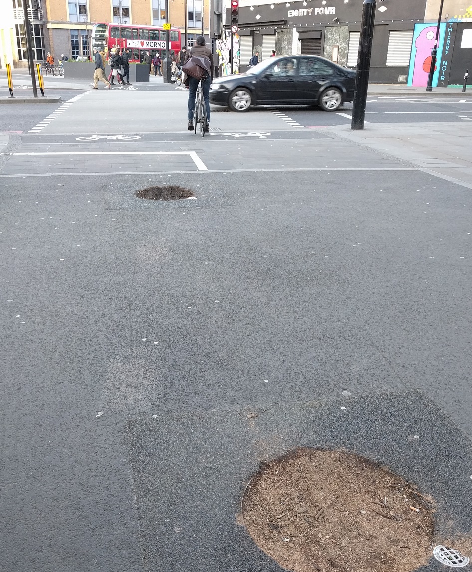


 Two of these trees were finally removed in early 2017


With a new tree planted directly in the centre of the cycle track, leaving just two trees in the track but at least with both of them are now located directly in the middle. 


Boris Johnson's final act as mayor was to order the removal of the shared space signage on the Apex Corner crossing of Old Street, which did occur, and to "install appropriate and effective vehicle blockage of Pitfield Street", which did not


CS1  then moves onto Pitfield Street and Hackney Council state that "Further closures are under investigation to reduce traffic crossing Pitfield Street." Whilst the bottom section of Pitfield Street was closed to motor traffic from Old Street it is still possible to access via Boot Street and this is a route many drivers make. Prior to CS1 Pitfield Street was only open in one direction for motor vehicles but bicycles could use it in both directions. However under the CS1 plans Pitfield Street was opened up to motor traffic in both directions, meaning drivers can now use Pitfield Street to drive south to Old Street, or to City Road via Haberdasher Street, something they could not make before this road became a cycle superhighway 


Pitfield Street before and after CS1

This is especially evident in the morning rush as hundreds of cars and vans use it as a rat run down to Old Street


Hackney Council stated that the zebra crossing next to New North Road would be "raised to slow traffic" and this work was completed in one afternoon shortly after that announcement earlier this year. There is another zebra just 500 feet north of this one, by Crondall Street. A local school, along with the vicar at St. Johns Hoxton church next door, have recently launched a "respect the zebra" campaign, resulting in a commitment from the council of a lollipop person, a slow sign and a repainting of the zebra, three years on from it being repainted as CS1 was constructed. I find it odd that the vicar is dressing up as a zebra to highlight how lorries should be stopping for pedestrians on the zebra crossing yet no one appears to be calling for either the lorries, or the huge numbers of other motor vehicles that clog this road up every morning,  to be removed from this "cycle superhighway" to allow it to be safe enough for children to cycle to school and easier to cross with some traffic reduction


There appears to be no plans for any improvements to Pitfield Street from New North Road up to Britannia Junction, despite this being one of the worst sections of CS1 within Hackney, a very busy road with an awful lot of motor traffic and certainly not the place for anyone "of any age" to be on a bike. The school run, weather on foot or bike, is almost exclusively carried out on the pavement here. 


It is also absurd that such a high number of lorries regularly use this section of Pitfield Street, especially coming from Mintern Street, which is a short 'quietway' route linking Shoreditch Park with CS1, yet is not even filtered!


Cycle super highway 1 and Quietway 16 meet at the Pitfield Street / Hyde Road and Hoxton Street junction. This is the most dangerous junction to cycle on within Hackney and I have written about it previously here. The council are "investigating a scheme to reduce traffic and simplify the junction" less than seven years after spending £600,000 to change it from one of the safest junction designs to the most dangerous! It has been slightly better this year as Penn Street on approach to it is now open in only one direction for motor traffic, reducing the amount of traffic crossing it from East to West but drivers can still use it as a shortcut west all the way from Bethnal Green to New North Road, resulting in near misses and collisions on a regular basis

A tree recently destroyed in a collision at Britannia junction

Again, there appears to be no changes planned for Whitmore Road or De Beauvoir Road from here up to downham Road, which is just unacceptable as motor traffic levels are far too high. I just don't understand why side roads leading off from CS1, such as Orsman Road or De Beauvoir Crescent remain open to motor traffic, let along why Pitfield Street itself is not filtered to stop through traffic from outside the area using it. 
Although not part of the original CS1 consultation a scheme was later proposed in De Beauvoir Town to filter more roads and create a much larger residential area that is free from rat running motor traffic


Most of these closures went into place in 2016, including one which had originally been proposed over 40 years earlier! The exception was De Beauvoir Road which, in response to the consultation, was kept open southbound but closed to traffic northbound. This has still resulted in it being much quieter than it was and also allows crossing De Beauvoir Road on a bike via Q2 much easier. The signage leading up to the closure isn't clear enough it seems, if the amount of reversing lorries is anything to go by. Originally the closure was simply some road signs, which were routinely ignored, but the recently changed layout does seem to be working well.

Getting from the longstanding filtered southern half of De Beauvoir Town to the northern half involves crossing Englefield Road, which can be a challenge at times, especially if you are cycling with young children. The council state that "a parallel pedestrian / cycle crossing is to be installed", which is great news, but I do hope it does not involve any pavement cycling. 
The new closures are working very well and have dramatically changed the area, creating a much quieter neighbourhood whilst improving the safety of those who choose to walk or cycle through here. I just hope that at the end of the 18 month trial the closures remain and the plastic bollards are replaced with something a bit more permanent. Unfortunately the closures at the junction of Kingsland Road with Stamford Road and Tottenham Road have still not been implemented, despite the consultation closing three years ago and the consultation page stating that they plan to start work in spring 2018.

In the 2015 consultation the majority of respondents opted for option B on Balls Pond Road; a bidirectional cycle track linking Culford Road with Kingsbury Road 


Three years on and work has still not begun on this section of the scheme, with seemingly no date that the works are even likely to start. Hackney Council claim that "this section is jointly maintained by Hackney and Islington and is also on the Strategic Road Network. Discussions are still ongoing but the aspiration remains for a protected cycle lane on Balls Pond Road between its junctions with Culford Road and Kingsbury Road"
It really is unacceptable to take this long to construct this vital part of the scheme. Families who want to use the well promoted "cycle superhighway" are either expected to take their lives into their own hands on such a busy and dangerous road or are forced to break the law and cycle on the pavement 
You can't even rely on an empty bus lane outside of peak hours as it then becomes a car park


North of here there are no plans to improve Boleyn Road, however since the 2015 consultation three new filters have been installed along Wordsworth Road, resulting in another residential area where all streets can be accessed by car but the streets are free from rat running motor traffic from outside the area, leading to quieter and safer roads for residents. 

A new "Cyclists slow down" sign has been installed on the cycle track between Wordsworth Road and Nevill Road alongside the children's posters with similar messages emblazoned onto the railings alongside


I believe a redesign of the cycle track and pavement here to a clearer layout would be a better solution


Before and after from google streetview
The transition as you exit this cycle track onto Nevill Road is quite stark, transferring from quiet streets to a very busy one, clogged with motor traffic at all times 


Hackney Council also recognise this problem and ran a consultation this winter on more proposed traffic filters in this area. Option A would eliminate East / West rat running entirely but would do nothing to solve the issues on Nevill Road and drivers would continue to use it to avoid the Stoke Newington Gyratory. Option B would see a filter on Nevill Road but would still see a West to East route open via Barbauld Road and Dynevor Road. Neither are perfect but option B would clearly be the best outcome for CS1 and those who live on Nevill Road who have to live with all the traffic. 

At Stoke Newington Church Street the promised traffic islands to provide a safe waiting area for cyclists following CS1 never materialised 


So, as with Balls Pond Road, a fairly important intervention needed as the superhighway meets a busy main road has not occurred and people continue to risk serious injury as they cycle here

Towards the end of CS1 in Hackney it follows West Bank, a one-way road (for cars) with houses along one side and a railway track on the other but with car parking along both sides of the road, leaving virtually no room for contraflow cyclists. 


Another consultation from the council proposes to strip car parking from the railway line side of the road for a bidirectional cycle track. It is a decent proposal as the car parking would not be missed however the local conservative councillor for this area, councillor Steinberger, submitted a 3,300-name petition against CS1 back in 2015, even though all that was proposed was "CS1" to be marked by paint on some residential roads. Some of his objections included increased cycling posing a danger to children and that any increase in cycling would result in increased traffic congestion. I await the consultation report with interest.

Hackney Council should be applauded for recognising that Cycle Superhighway 1 has some serious issues and is largely not a pleasant place to cycle and I'm very glad they seem to be proposing some good solutions to some of the issues. However, it would obviously be welcome if they could actually finish all the adjustments to this route that were promised three years ago but have still not been delivered. 

Sunday, 6 March 2016

Cable Street CS3 Consultation

I haven't really used any of the fantastic looking new superhighways that have recently opened or are nearing completion in London. I have used Cycle Superhighway 1 in Hackney, quite a lot as it happens, and that is pretty awful but then it is only a superhighway in name as it has virtually no dedicated cycle infrastructure on it and also runs mostly on busy rat runs so can't really be classed as a quietway either. It is, in the main, just a very busy road that has been resurfaced and is now actually a busier rat run in places as turning Pitfield Street two way has opened up more routes for motor vehicles to use. I haven't used CS5 in South West London as I've had no need to be there but did use CS2 between Bow and Stepney Green on one occasion and whilst the finished section of it was marvelous the section where the construction work is taking place was a very unpleasant place to be on a bike. After sharing such a narrow space with lorries within the construction works I vowed that I would not cycle on CS2 again until the works were finished and the superhighway was fully open. I did happen to take a detour (on foot) to look at the very first section of  East West superhighway on the Embankment between Northumberland Avenue and Westminster Bridge whilst it was under construction but have not yet cycled on any completed part of it. One reason for this is that I'd really like to cycle all the way from Tower Hill to Hyde park on the completed superhighway, and enjoy it once it is complete without having to navigate through tight restrictions sharing space with lorries at construction works.

One activity I plan to do once I've tested the East West superhighway out on my own is to take my three year old for a ride along it as well. I've only ever cycled with her on my bike once on the Embankment before (or indeed anywhere close to Central London as I tend to mostly stick to either Victoria Park or the Regents canal) and that was on the Ride London event of 2013 when she was just a year old. I'm fairly lucky to live where I do as it allows me to be able to cycle with her through Victoria Park and from there take the traffic free Regents canal to Limehouse Basin, and then a short, almost traffic free route to Cable Street which has a 2km long direct and continuous segregated cycle track all the way to Tower Hill. After cycling this route three years ago it was then a joy to cycle side by side with her mother along a closed embankment, chatting away for a good couple of hours and taking pictures of our daughter in front of the House of Parliament, Buckingham Palace and various other landmarks that are usually surrounded by speeding motor vehicles. I have not been with her on a bike in Central London since then as there simply isn't a safe enough route to allow us to be able to do so and we therefore tend to stick to shopping in Westfield by cycling through the traffic free routes in the Olympic Park instead.

I've been watching the construction works slowly complete and various sections open on both twitter and the Transport For London traffic cameras with excitement and had already begun planning several family trips to Central London this summer now that a safe, comfortable and continuous cycle route will be available to allow us to enjoy days out in the West End on our bikes. I was therefore pretty shocked and dismayed to recently see that Tower Hamlets Council are planning on making changes that mark the end of the two way cycle track along Cable Street.

A map showing the proposed changes to Cable Street
Cable Street is an extremely popular cycle route, the most popular road to cycle on in the UK in fact. In a way it is a victim of its own success as this was an old LCN+ cycle route which was built back when commuter cycling trips in Central London were much lower than they are today (and then painted blue around six years ago). The bi-directional cycle track is quite narrow in some places and therefore it can get heavily crowded at peak times. However it is still a mostly pleasant route to use and much safer than cycling along The Highway or the A13, both a very short distance to the South and North of it respectively.

Tower Hamlets council make clear that they are proposing these changes for several reasons:

  • To make the area more pleasant for residents and visitors to the area by cutting down on rat running traffic as 76% of motor vehicles using Cable Street are passing through the area.
  • Pedestrian cyclist conflict at Watney Street and at the three zebra crossings at this stretch, and in particular the zebra crossing outside Blue Gates Fields Infant School.
  • Cyclists find the two-way cycle lane uncomfortable as it is too narrow for peak demand

This is not a very detailed consultation leaflet at all with only the one visualisation and virtually no detail on the designs or traffic flows post filtering. However lets look at the changes from East to West as detailed in this consultation.

The end of Cable Street at the junction With Butcher Row
The right turn for motor vehicles will be closed here forcing traffic to turn left into Butcher Row northbound; this is designed to stop people diverting from The Highway onto Cable Street to use it as a rat run to get to the Limehouse Link Tunnel. However as we can see from the proposed map above traffic will still be able to use it as a shortcut from the Highway onto the A13 by using this route. There is no detail on what will replace the space created by removing the right turn here but hopefully it'll mean widening the very narrow cycle track used to access Cable Street from Butcher Row southbound. The blue painted cycle lane in this picture will now only be used by westbound cyclists with people cycling east using the main carriageway instead. As many of these cyclists will want to continue along CS3 through St. James Gardens I hope a proper cycle crossing is also designed that helps prevent cycle collisions as the two streams of cyclists pass each other. It would also be a huge bonus if the council could take this opportunity to upgrade the superhighway here. At present cars drive on the superhighway to reach a space reserved for six car parking spaces - this would make a nice public space if the parking spaces were removed with an upgraded cycle track (perhaps similar to the one at Angel). An upgraded Tiger Crossing over Butcher Row that actually links up with CS3 in St. James Gardens would also be a huge improvement, rather than the current set up 

The cycle track passing Cranford Street
The cycle track west of Butcher Row will remain but will only be used by westbound cyclists, people cycling east will have to do so on the narrow main carriageway

The Cable Street crossover between Pitsea St and Stepney Causeway
The comfortable, good quality cycle track only lasts for a little over 100 metres before this right angle crossing appears, something which is almost impossible to actually use and would never be employed on a highway for motor traffic weather it was classed as super or not! Most people cycling here do not use the crossing as intended and instead tend to cycle into the road into the oncoming traffic before accessing the cycle track on the other side of the road a little further on. As the consultation states that westbound cyclists are to stay on a "mandatory cycle lane" beyond this junction with eastbound cyclists on the main carriageway I assume that this crossing is due to be removed, with a new cycle lane up the left hand side of the road and the main carriageway presumably moved slightly to the north where the cycle track currently is. I'm worried about the mandatory cycle lane; how wide will it be? What is to stop people from being able to park in it? Will it be watered down to just some painted bike symbols on the road?  The consultation lacks these kind of, fairly important, details.

Cable Street at the junction with Broadlove Lane
As can be seen by the painted arrows on the main carriageway this is where Cable street switches it's one way direction and at the moment traffic coming out of Broadlove lane can turn either way but will, if these proposals go ahead, only be allowed to turn right, where it can then freely rat run to the end of Cable Street to quickly access Commercial Road when The Highway is heavily congested. A closure for motor traffic will go in here, presumably between the Zebra crossing and Broadlove Lane although it is unclear if the zebra crossing will stay or go once this section can only be accessed by people cycling or walking. This is the point where the #space4cycling is planned to switch direction with the mandatory cycle lane ending westbound and the eastbound cycle track ending and becoming the main carriageway. There is a potential issue for motor traffic turning right out of Broadlove Lane which will have to give way to cyclists on the westbound cycle lane coming to the right of them and then, hopefully, also give way to eastbound cyclists to their left at the point where the eastbound cycle track becomes the main carriageway. Clearly this will be a tricky junction to design, with limited space, to ensure the current priority for cyclists remains and conflict is designed out as much as possible. This junction is currently very safe for people cycling so I'm concerned at how the new layout will turn out.

Cable Street between Davenport Street and Glamis Road
The cycle track remains here but only used by people cycling east, with westbound cyclists on the main carriageway. I assume that the car parking remains and so the advice will be to "take the lane" and to cycle out of the door zone in the middle of the road to stop any possibility of being "doored". Unfortunately both Davenport Street, Glamis Road and Sutton Street remain fully open to two way traffic so are prime roads for drivers to use as a shortcut between the A13 and the Highway. Taking the lane here and risking harassment with motor traffic directly behind you might be acceptable for many of those who already cycle but not for most people who would like to take up cycling, especially children or the elderly, who will surely find it very intimidating. The most sensible solution here would be to remove the car parking to make space for cycle tracks along both sides of the road, similar to the proposed layout at Tavistock Place. This has been a public highway for at least 250 years so not sure why it is being used to store peoples personal possessions in a ward where 62% of households have no access to a car.

The current layout past King David Lane and Sutton Street
The proposed layout past King David Lane and Sutton Street
So this is the only visualization in the entire consultation. As can be seen the plan is to rip out the cycle track and guardrails to create a road with some bicycle symbols painted on it. King David Lane will have a bus gate (with CCTV enforcement) so only buses will be allowed to access Cable Street from it with the consultation stating that vehicles will be "forced to use the Glamis Road Junction".

When I stood here earlier this week there was constant movement of motor vehicles and most of that movement was traffic coming up King David Lane and then accessing Sutton Street, including all the vehicles in this photo.
All of the traffic that currently uses King David Lane will just switch to Glamis Road, the next road along, to access Sutton Street. However to do this they'll have to drive 200 metres along Cable Street; a very worrying proposal as people cycling along here will have to do so on the main carriageway, acting as a traffic calming measure for all the motor traffic that will still use this route, including large commercial vehicles. A huge step backwards.

Cable Street outside Shadwell Overground station
This section of Cable Street is where pedestrian activity is highest and the road here will be access for residents only and through traffic for buses, cycles and emergency vehicles. The two buses that will use this section of Cable Street are route 100 and route D3. Bus route 100 is a six mile journey, which takes one hour and six minutes at peak times if on schedule (about the speed of a chicken). With eight buses an hour travelling up Glamis Road from the Highway and then driving around 600 metres before terminating at bus stop B just before Cannon Street Road. This is the same stop is starts at again before turning left onto Cannon Street Road towards the Highway. Bus Route D3 is a ten mile journey, which takes one hour and 12 minutes at peak times if on schedule (about the speed of a donkey). With six buses an hour although it only travels via Cable Street going from the Isle of Dogs to Victoria Park and misses it out in the other direction. So that is roughly one bus every four minutes using this stretch of road and the London Cycling Campaign are quite clear on their policy regarding buses:

1. Where the core cycle network coincides with a bus route, usually the 'protected space' test will mean we need to separate bicycles from buses, at route level or at street level.
2. Separation at route level can mean re-routing buses (for example, to create a cycle-only street, as in The Narroway, Hackney), or re-routing the core cycle network. If the second option is chosen, this must maintain network density and directness, and access to key destinations.
Clearly these two bus services should be re-routed; Bus route 100 could terminate on the Highway instead of on Cable Street, considering The Highway is only 150 metres south at this point. As bus route D3 does not serve Cable Street in one direction I don't see how not serving it in the other direction would be a huge issue; again it can stop on the Highway very close by. This would allow this section of Cable Street to become a bicycle only road, with wider pavements. Lets also not forget that if the DLR or Overground is suspended through Shadwell then rail replacement buses will also use this road with a bus running potentially every minute or two. Sharing this stretch of road with buses is fine for me but if I'm with my daughter I'll probably be cycling considerately on the pavement. I wouldn't expect many young children to cycle along here in front of buses either and many will opt for the pavement if they do decide to cycle at all, hardly an improvement for pedestrians. The Tower Hamlets cycling strategy states that "we want to encourage cycling for all, from 8 to 80 years old and remove the barriers that stop people cycling" and that "our target is to achieve 12% of all children cycling to school [by 2025] and our aspiration is for 20%" taking people off a segregated cycle track and putting them onto the main carriageway directly in front of buses is not the way to increase cycle to school rates.

Cable Street between Shadwell Overground station and Cannon Street Road
The wide cycle track will remain for eastbound cyclists with people cycling towards Central London using the main road here again mixing it with buses. If buses were rerouted then cycle tracks could be built on both sides of the carriageway here.

Cable Street west of Cannon Street Road
And that is where the consultation ends. No mention of what happens at or after Cannon Street Road. Will the two way cycle track remain here? If so how will cyclists access it from the main carriageway? If not will they be forced to use the main carriageway directly in front of motor traffic rat running from the A13 to the Embankment? Again there is a lot of car parking along her so clearly the space for cycle tracks on both sides of the road.


The reason Cable Street is the most popular route for cycling in the UK is precisely because of this cycle track. Yes, it is imperfect in places but people go out of their way to use it. Yes, it can be slow and busy at peak times but people still use it in huge numbers as they don't have to dodge parked cars, take the lane in front of lorries or squeeze up the inside of buses to get to the ASL. If you build segregated cycle routes, even if they're not perfect, the cyclists will come. I'm sure that, just like Tavistock Place, many people in London started cycling because of the cycle track along Cable Street. I used to go out of my way to use this cycle track if I ever needed to be in the Limehouse / Canary Wharf area just as I used to go out of my way to cycle down Tavistock Place if I had to be in the West End. It is an interesting to compare the Tavistock route with the Cable Street route; two examples of segregated cycle tracks that became so popular and have attracted so many users that they ended up being way over capacity.

Lets revisit the reason for these changes:
  • To make the area more pleasant for residents and visitors to the area by cutting down on rat running traffic as 76% of motor vehicles using Cable Street are passing through the area.
If 76% of motor vehicles are rat running then this area absolutely needs some traffic filters or an altered one way system to make it impossible to use Cable Street as a through route if travelling in a motor vehicle
  • Pedestrian cyclist conflict at Watney Street and at the three zebra crossings at this stretch, and in particular the zebra crossing outside Blue Gates Fields Infant School.
Again as I've suggested rerouting buses here and making it a bicycle road with larger pavements and pedestrian priority would be a good solution
  • Cyclists find the two-way cycle lane uncomfortable as it is too narrow for peak demand
Just as on Tavistock Place the cycle track could instead be doubled in capacity by the existing track becoming a wider one way track and building a new track on the opposite side for westbound cycles. This would be possible to do along most of the route, if car parking were to be sacrificed. However there would not be the space available to do this towards the eastern end of Cable Street so again a bicycle road might be a possible solution as all of the side roads in this area can be accessed from either the A13 or The Highway. There is plenty of capacity on these two roads to take the displaced traffic from Cable Street. If this is not possible then another solution could be cycle tracks on the A13 and on the Highway; along with the soon to be completed CS2 cycle tracks this would lead to a huge increase in capacity for cyclists travelling East West through the borough, leaving the Cable Street cycle track as a lighter used more "local" option for people in the Shadwell area. Usage of Cable Street will likely decrease soon anyway as people living closer to the A11 switch to using CS2 rather than divert to CS3. I'm sure usage will drop dramatically if these plans go ahead and people are kicked off the cycle track into the road!

There are some very nice places to cycle in Tower Hamlets, such as along the Regents and Limehouse Cut canals, alongside the River Lea and River Thames, through Mile End and Victoria Park, the Greenway and parts of the Olympic Park. However most of the main road network is terrible for cycling, which is probably why only 3% of journeys in the borough are made by bike, shamefully low for an inner London borough. This is the flattest borough in London, with the City of London at one end and Canary Wharf at the other; it should have a much larger number of trips being made by bicycle. The fact that despite the low cycling rates it contains the road with the highest number of cycle trips in the UK in it shows that the demand is there, we just need the required infrastructure to allow it to fulfill that demand.

The council say all the right things in their cycling strategy:
Over the next 10 years the population is expected to increase by an additional 20%, to reach more than 320,000 residents by 2023.  Sustainable growth needs a sustainable transport system and Tower Hamlets’ vision is for cycling to play a central role in the borough’s growth in order to relieve congestion on the roads, buses and train systems. We want Tower Hamlets to be one of the easiest and safest places to cycle in London and to make cycling the natural choice of transport for most people. 
A map of the future cycle network in Tower Hamlets
Much needed upgrades to current cycle routes along the Grove Road / Burdett Road and Cannon Street Road / Vallance Road routes should, if they are built to a decent quality, form a real backbone of cycle routes in the borough and link CS2 and CS3 together and with the north of the borough. However there is nothing planned at all for Bethnal Green Road, a very wide road and an essential route for people cycling from Bethnal Green into the City. The council did once try to build some cycling infrastructure here but so bad was it that it was removed within a few days.

There is a lot of work to do in Tower Hamlets to make cycling a safe, inviting and convenient mode of transport for all, however Cable Street should be near the end of a very long list

I will be emailing Tower Hamlets council to ask them not to go ahead with this plan as detailed in this consultation. It closes on March 14th, respond by emailing cycling@towerhamlets.gov.uk

Wednesday, 28 October 2015

The history behind how De Beauvoir Town became a low traffic neighbourhood in the 1970s

I've written before about De Beauvoir Town, which is a very pleasant area of Hackney to live in, for lots of reasons, one of them being due to the various bollards and restrictions in the area, which ensures that the roads are restricted to through motor traffic but that they remain open to pedestrians and cyclists, which reduces motor traffic across much of the area to a very low level. This creates quieter conditions for residents, streets where children can play along with an added advantage, due to it's location, of a direct & quiet East-West cycle route from Islington to Hackney via London Fields along with the so-called Cycle Superhighway 1 which is a not-as-direct-as-the-A10-but-quieter-than-it route from Shoreditch to Dalston.

Towards the end of the 1950's the Victorian terraced houses on Buckingham Road and Tottenham roads were demolished and replaced by the Kingsgate Estate, opening in the early 1960's. Shortly later hundreds of Victorian houses, pubs, shops and about half a dozen streets (almost all land between Downham Road and the canal, bar the industrial buildings surrounding the Kingsland Basin) were swept away to make way for The De Beauvoir Estate. In 1968 plans were then developed to demolish almost all of the rest of De Beauvoir Town with low rise housing estates replacing the Victorian terraced houses. Two newcomers to the area, Stuart Weir (who would go on to become a local labour Councillor for the area) and Robin Young, both journalists on The Times who lived next door to each other on Balls Pond Road, were appalled with the threatened destruction of the community. They decided to do something about it and leafleted the whole area shortly before the council elections in order to hold a meeting with local residents and the ward Councillors in the crypt of St. Peters Church. On the night the Crypt was crammed with around 200 angry local residents and within weeks the De Beauvoir Association was formed with Stuart Weir serving as Chairman.

I know that this is what happened in 1968 as it is detailed in an interview with Stuart Weir in issue number 31 of the De Beauvoir Association newsletter, which is archived here, along with over a decade of other issues. These newsletters give a fascinating insight into the early years of the De Beauvoir Association, the politics and struggles behind implementing the road closures, and general activism in the area during the 1970's.

The De Beauvoir Association tried, but failed, to save the Eastern side of De Beauvoir Square which was replaced by the Lockner Road estate, after council officers persuaded the newly elected Tory Hackney Council that these houses were beyond repair. Staggering to think these beautiful homes were destroyed, they'd each be worth several million pounds today. However a year after their creation the association managed to ensure that most of De Beauvoir Town became a conservation area, almost certainly saving it from destruction. A year later the Central General Improvement Area (GIA) plan was set up with an advisory committee of local residents. During 1971 surveys and meetings were arranged with local residents to try and gather ideas and plans for improvements to the Town with environmental issues figuring prominently, including play & amenity areas for local children along with road closures to divert dangerous through traffic. Plans were put forward to the council with Issue Five of the Newsletter in January 1972 declaring that the

"Road plan goes on show"


Most of the closures that were proposed did eventually happen, however the plan was for traffic to be banned from De Beauvoir Square entirely except for Milk Floats, removal vans and emergency vehicles. The plan stated that Pedestrian Ways were to be left through the closures so that you can still "pop round the corner (only more safely)". The closures followed two traffic surveys - the first, a count of all vehicles using local roads (in which residents helped the council); the second, a study of where the vehicles had come from and were going to. They showed that much of the traffic had no business in De Beauvoir. Before these plans were put forward to the council The GIA Residents Steering Committee had argued strongly that De Beauvoir Road and Downham Road should also both be closed. In particular it was felt that De Beauvoir Road cut the "New Town" in half.

It is worth noting here that the "De Beauvoir Estate" is never mentioned by name in any of these newsletters; it is always referred to as either "The New Town" or "The New Town Estate" with the rest of De Beauvoir referred to as "The Old Town".

The closure of De Beauvoir Road or Downham Road looked unlikely as borough engineers argued that the roads carried too much traffic that couldn't be thrown onto busy main roads and relieved overburdened roads like Englefield and Southgate Roads of traffic they couldn't bear. Planning officers warned that they had tried to close it when they built the De Beauvoir Estate but the ministry of Transport vetoed it. The Greater London Council (which had overall responsibility for traffic in London) also restricted the road closures to the central area GIA. New Town residents argued that commuter traffic was the problem and that their children should not unnecessarily be exposed to risk just to cut a few minutes off a commuters journey.

Issue Five of the newsletter was paid for by Hackney Council to try to ensure local residents engaged with the plan and submitted ideas, suggestions and criticisms. It was stressed that the plan were only provisional, not fixed and gave alternative ideas to choose between. To quote the newsletter "We hope parents will take their children along and get them to write their comments too; if they don't, go along by yourselves kids!" An improved quality of life for the Children of De Beauvoir was a large part of these proposals and this was emphasised further on in this issue under the headline "But mum - where CAN we go?"

We assume that a broken glass window caused by a boys ballgame on the street begs an apology & replacement of the glass by the boys. Less expected is the apology which the children in De Beauvoir are owed because of the total lack of play facilities. This is how some of them feel.

Also in this issue of the newsletter five local people discuss the plans impact on the area and we start to see the divide in opinion on the "old" and "new" areas of De Beauvoir:

Most people would agree that traffic in Northchurch Road should be severely restricted, if not banned altogether. It is questionable, however, whether adequate thought has been given to the effect of such a closure on the southern area. Downham Road is already both busy & dangerous; the Council has plans for a library & community hall on Downham Road and a workshop for the elderly is being built. Downham Road could link, rather than divide, the two communities. The present proposals for the central area are to be welcomed in that they deal adequately with some of the major problems. No plan will ever please everyone but by confining the proposals to the central area, the Council lays itself open to the charge that it is looking after the interests of the central area residents at the expense of the rest of the Town. 
Charles Maitland.

In the next meeting to debate the plan local people overwhelmingly voted for the closure of De Beauvoir Road, however most criticism came from people living near the proposed "play areas"

Local children, it seems, swear vociferously, kick footballs everywhere, and can climb even out of 50 ft. deep pits (Obviously Hitler is lucky he did not win the war!) Parents protested back. "What do you want us to do, drug them?" an irate mother shouted. "No, drown 'em" a man called back. A few people suggested reasonably that boys would kick footballs about anyway; it was surely better that they weren't dodging cars at the same time?

During 1972 it became clear that the trial road closures would be delayed due to new legislation. Hackney Council also delivered a huge blow to the residents steering committee that they had agreed that De Beauvoir Road would not be closed to through traffic. They also back tracked on the plan to close the road around De Beauvoir Square to make room for play and amenity areas. Now the council officers proposed to keep a 13-16 ft. road around all sides, much to the shock of the committee.

"NONSENSE -  If you, your children or your old folk:

  • Have to cross from one side of the new town estate to the other (to reach shops or the new community centre, when it is built)
  • Want to send your children to play in the new amenity areas in the square from the other side of De Beauvoir Road
  • Have to cross Ardleigh, Stamford or De Beauvoir Roads, particularly at peak traffic periods
THEN THE COUNCIL'S DECISION SHOULD BE OF REAL CONCERN TO YOU. LET'S GET READY TO PROTEST ABOUT IT."


Pending the closures there were several other matters relating to roads in the area that the association or local residents, presumably brought together through the association, began to turn their attention towards. A petition of over 400 signatures was collated calling for a pedestrian crossing on Southgate Road between Northchurch Road and Downham Road following the death of an elderly woman and a child being seriously injured after being struck by a car. The petition had no effect as no crossings exist between these two junctions today and a report in issue nine in December 1972 explains why

 "GLC puts van before lives: Officials took a count of the people trying to cross Southgate road and the traffic. They got the right people count and the right traffic count, for a crossing. However the GLC and police said there wasn't a good case for a zebra crossing as shops could not load or unload goods. They may put traffic refuges in the middle of Southgate Road in a couple of places. Big deal. Give us our crossing. Lots of local residents are already angry as the news travels."

"Extend School onto road - and shut out traffic"

The GLC and the Inner London Education authority were seeking to extend RC Kingsgate Junior and Infants school by compulsory purchasing seven houses next door to it along with Gardener's warehouse (a hay merchant for any horses still knocking about). However the association argued that it made more sense to extend the school over Tottenham Road and onto derelict land opposite it, saving the houses and bringing the added benefit of closing Tottenham Road to through traffic.


Left: The DBA's plan for the school extension and the modern view (right) of the extended school as it is today, showing the plans failed to be taken seriously. Tottenham Road remains open to through traffic today, despite having two schools located on it and the A104 Balls Pond Road located less than 100 metres away

There was strong backing locally for the closure of Tottenham Road, which was used by through traffic as a notoriously dangerous slip road alternative to Balls Pond Road. The parents and staff of the De Beauvoir School had expressed their concern, and Hackney Council had been willing to agree to the road closure.


"Balls Pond Road Block"

The Balls Pond Road lollipop lady, Mrs. Hubbard, was knocked down in July 1973 during the school run. Local parents protested for a crossing by blocking Balls Pond Road on the first Monday after the Summer Holidays, wheeling Mrs. Hubbard, in her new wheelchair, into the road. Mrs. Hubbard describes the demonstrations in a follow up issue of the newsletter, along with advice to others planning any demonstrations:

"The first demonstration was on the Monday and this was a great success. The drivers did not know what had happened and this came as a surprise to them. When doing this make sure it is the busiest time of the day, and do it unexpected as the police and bus officials will divert the traffic. Never let them know too soon or else you are left without any traffic. 
"How many more deaths before we get a crossing?"
The second time we stopped the traffic we let the police know too early, so they diverted the buses and traffic. So that made up our minds not to inform the police until we were ready to walk in the road. With banners and Terry Hemmstead, our leader, we blocked Kingsbury Road stopping the traffic going into Balls Pond Road. 
Make sure you have plenty of banners and make sure you have all the parents behind you. Never get stroppy with police, or else you won't get anything. The third one was a success - police officials, traffic officials and council officials came down. Our leader and me knew we had them worried; Terry Hemmstead told them we would be willing to have a meeting in Kerridge Court after we had finished the demonstration. The officials said they would promise to bring it up in the next meeting. Mr Hemmstead was speaking for all the mothers when he said, "We are not interested in talking or promises. We all want action and nothing else". Hackney Council put up a temporary island which helped a lot - this was after three or four demonstrations. And thanks to Terry Hempstead and all the mothers and fathers we have got our lights"

Initially the council used a formula to determine if a road needed a crossing although, quite unbelievably, any children aged under twelve were not counted when working out this formula as "they were not thought responsible enough to use a crossing properly"!

The pedestrian crossing the parents of children from De Beauvoir Primary School fought for still stands and is well used to this day. A short two-way cycle track will soon replace the barely used bus lane on the left 


What is striking about these demonstrations in the early 1970's is that similar demonstrations were taking place at the same time in the Netherlands. This fascinating post by Mark Wagunbuur is worth reading if you haven't already, featuring children and parents fighting for roads to be closed to motor traffic in the Amsterdam suburb of "De Pijp" in 1972. Also the accompanying edited and subtitled video of the documentary which inspired the post is well worth taking ten minutes out of your day to watch. De Pijp is a very different area today, thanks in part to these demonstrations in the early 1970's, just as the rest of the Netherlands is very different today than it was in the early 1970's after Dutch authorities deliberately turned their attention away from demolishing areas of their cities to make space for cars and instead turning them back into safe places for people. This did not happen by accident and it took a long period of campaigning to turn the Netherlands into the people and bicycle friendly country it is today. This all started with parents blocking roads to campaign to make their streets safer for their children in the Early 1970's, just as the parents of children in Hackney were doing at the exact same time.

December 1973 and the newsletter reported that it was looking likely that the much-delayed temporary road closures in the central area of De Beauvoir would be introduced by the end of January 1974.

The play area in De Beauvoir Square was to have been in the roadway near the houses but a new plan removes the play area (and the kids with it) to the centre of the square. A few people on the residents steering committee would like to see the all the play facilities planned for Northchurch Road transferred to the Square. But if the play areas are removed from Northchurch Road, much of the case for closing the road to through traffic is removed too. One thing is certain; the majority of De Beauvoir residents who live outside the central area won't be prepared to suffer from the extra traffic and parking which will result from the road closures unless facilities are provided in the traffic free areas created.

The experimental, temporary road closures finally went in place on the morning of Monday, April 8th 1974. Two months later and Issue 16 of the newsletter showed that not everyone was happy.

"Road Closures: New Town 'cut off and abandoned'. Militant mums demand action now"

New Town tenants are in a militant mood over the experimental road closures and a Tenants' Action Group, headed by Emilie Chalk, has been formed to make their voices heard above the roar of traffic thundering along Downham Road. As we were going to press, the action group announced plans for demos on June 13 and June 14 to block De Beauvoir Road and Downham Road at the crossroads. They feel cut off and abandoned and want Downham and De Beauvoir Roads closed before a child dies. If the council do not agree they demand that Northchurch, Hertford and Enfield Roads are reopened to through traffic. Backed by worried mothers, Mrs Chalk of Trinity Court, has been collecting thousands of signatures for a petition protesting that the closures have made some roads more dangerous than ever for their children.
Soon after the road barriers went up, Wally Richmond, a blind tenant was nearly killed twice when frustrated motorists squeezed past barriers over the pavement. He was one of the people who demanded action at a stormy public meeting in the community hall. DBA chairman Graham Parsley warned that this was turning into an "Old Town vs New Town battle" and was just what the GLC wanted.
"We must fight together. If the pressure is built up then we can get something done when the six months (of experimental closures) is up."
Mum's Chorus:
"We can't wait six months."
"Take the barricades down now!"
"All these committees are no good. We'll close roads ourselves and chop down the barriers"


The letters page also showed the strength of feeling against those who were trying to block any play areas from being built near their homes in the closed off streets

People who are against play areas outside their homes want the best of all possible worlds. They already live in the best houses in the best roads in the area. Now - after many years hard work by members of the Residents advisory committee and the councils officers  they are to benefit from a traffic scheme which will keep through traffic away from their doors. But instead of being delighted they now want the whole scheme abandoned in favour of a watered-down alternative which will make their own roads more attractive than ever, but without providing anything for the community in return.
Naturally there is a strong argument against the proposed play areas on aesthetic grounds (wouldn't we all like our own streets to be closed, paved and tree-lined!) but in my view this is over ridden by the need for community play and amenity space. If it can be proved that no such need exists, would they be prepared to see the whole scheme dropped in favour of a traffic scheme based on the closure of Downham Road? Such a scheme (which could provide a linear park for the benefit of both the old and new towns) would make good sense. But it could mean a cement mixer along Northchurch Road every few minutes. The residents must sort out their priorities.


From the critical reaction there has been to the experimental road closures from many people outside the 'closed' area and from the New Town, it would seem that any further discussion about weather or not designated play areas are to be provided at the Northchurch Road intersection is now irrelevant. It is clear that residents living outside the 'closed' areas will not continue to suffer from extra heavy traffic unless the closed roads are put to community use. If they are not to be used, the closures must be transferred to areas where community use will be welcome.


And finally a letter from Mr and Mrs Parrott, who's son was killed on Northchurch Road, the street where they live just two years before the closures went in:

My wife and I have now had the opportunity to enjoy living in this area after such a long period of excessive traffic noise which until now had been a constant disturbance. It is our opinion that the proposed changes to this area will vastly improve the local environment. More is the pity that such changes were not possible earlier. The idea of play areas must surely be welcome to those families with small children who cannot for so many reasons find the time to go the distance to suitable recreation places for young children. And who would deny the opportunity to those that are less fortunate and have no space at all. We feel that the authorities have a duty to the New Town especially and everything possible and within reason should be done to make provision for them and the various age groups to cater for their interests. The trouble caused by some young persons is very likely due to the lack of facilities to release their energy into something more constructive.

The only complaint printed about the inconvenience the closures brought for those driving in the area was from Dr. Ashan of Southgate Road "The closures are costing us time and money and of course it is causing us a lot of worry. It disturbs us that the closures seem to have been the wish of a few rather than the Majority."

There were also complaints from some residents that "Those bloody buses are shaking my house to pieces"  referring to the 10 buses per hour (or as many as 20 per hour on Saturday afternoons} which had been re-routed through De Beauvoir Road and Downham Road to complete a 'turnround' which used to be made through St. Peter's Way, the South Eastern corner of De Beauvoir Square and the bottom of Hertford Road before the road closures.

Astonishing today to think that such a quiet and tranquil place such as De Beauvoir Square once had up to 20 buses an hour using this section as a turnaround, along with all the other through motor traffic.

A year on from the experimental closures and Issue 15 in April 1975 looks ahead to the council voting on the road closures becoming permanent

"Crucial roads vote on Wednesday"

During the first nine months of the experimental road closures the accident toll on the road affected fell by 37%. This represents a saving to the community of approx £32,500. In Downham Road accidents fell from 10 in the previous nine months to three after the closures. On De Beavoir Road the drop was from five to four. In Northchurch Road, previously with a bad accident record, there were none. In 1972 the council approved the plan with only one vote against the principle of road closures. In 1975 the situation is different, and it seems likely that some votes may be cast against the permanent road closures. Objectors to the scheme say all the benefits are for the Old Town residents, mainly at the expense of the New Town. The main purpose of the scheme is to create open space and play areas in a part of Hackney severely deprived of them, from which all residents of De Beauvoir will benefit. People outside the area may be aware of the 800 strong petition against the road closures but may not know the signatories were led to believe they were petitioning for something quite different - the closure of Downham Road and De Beauvoir Road, something the council has always refused to consider. 

That same month Hackney Council voted to make the road closures permanent by 29 votes to 17. The main opponent to the scheme was Councillor Bob Hasters who said that "one person's traffic free area is another person's traffic problem". He and several other councillors claimed that traffic had increased in their areas since the closures.

Councillor Eileen Cox said that the road closures were necessary to provide two acres of much-needed play space with no housing loss and that the closures had already cut down accidents throughout De Beauvoir by more than a third. She ended by arguing that "people were more important than cars" receiving warm applause as a result. Councillor Alf Linzell argued that the scheme was not just for one privileged area, but should be the first of many other schemes. He stated that these traffic-free areas were needed to  make Hackney a more pleasurable borough to live in.

The newsletters of the De Beauvoir association continued for a few more years until they became semi-regular, appealing for more volunteers as many of the contributors were moving out of the area, before ceasing publication in 1984. The final issue gives an insight into life in Hackney in the 1980's and how times had changed since the community-minded, optimistic activism of  the previous decade

The facts are clear: Hackney has the lowest average incomes in London, one adult male in four unemployed, one in five dwellings unfit, the people living there express greater dissatisfaction with their area than people living anywhere else in the country, children achieve the worst educational results in Inner London, and so the list goes on. The Department of the Environment recently classified Hackney as the most deprived local authority in England.
Paul Harrison - De Beauvoir newsletter, March 1984 in response to criticism of his book Inside the inner City.

The De Beauvoir association, which had achieved so much in its lifetime ceased to exist until it was reformed in 2004. With its closure the play areas were never built. The bollards, which were only intended to be temporary and were to be replaced by seating and trees, remain there to this day. New Town residents who voted for the scheme in 1975 would probably be furious to see that what they had expected to become play areas for their children are now areas that are mostly used by cycling commuters from outside the area, bar some local kids kicking a football about away from the threat of motor traffic. The residents in the Central area of De Beauvoir now live on quiet streets and many people who choose to cycle in Hackney have a pleasant and safe East-West route to use in the West of the Borough. This was never the intention but I believe these closures did do much to benefit many Hackney residents from outside the area. It is a shame that this was not duplicated on a much larger scale across Hackney or Inner London.

We can learn much from the early days of the De Beauvoir association; it is impressive that a small number of people managed to inspire their community to not only save such a lovely area of London from destruction but then vastly improve it for future generations. It was well organised campaigning, lobbying and protesting that saved De Beauvoir Town, restricted motor traffic in the area and ensured local children had a safe walk across Balls Pond Road to get to school. It seemed to help immensely that the association listened to local people and campaigned for what people told them they wanted, not what they thought they wanted. Stuart Weir explains the openness behind the association:

The DBA was non-party political right from the start, and its membership was a political cross-section in the same way that our meetings always showed a cross-section of tenants, leaseholders and owner occupiers. I think one important thing was that we took care to set up an Association which was broadly based and stayed alive to new needs and new issues through the informal open committee idea. We carried out opinion surveys to find out what people really wanted to happen to the area, and the success of the association can be measured by the fact that as many as 75 to 80 per ' cent said they were aware of the DBA and what it stood for.  We organised an advice centre, every Saturday, to help residents with their problems and to take up cases. We organised stunts, we got tenants together to demand repairs from their landlords, we tackled the GLC about extending the Conservation Area, we got the Victorian Society and John Betjemam to take an interest in the area. We started a playgroup, we carried out a survey of Welfare rights with the council. 'We tried to find out what people thought and what they wanted for their community. We were never just concerned with conservation and the environment - that would have been disastrous.

The Future of LTNs in De Beauvoir Town

40 years since the road closures went into place and they're referred to in campaigning circles these days as Low traffic neighbourhoods instead. That is, whilst they stop rat running motor traffic from using these roads  they are well used routes for bicycles. Currently out for consultation is for five new "filters":


Whilst all the of closures from 1975 are located in the Central area, between Downham Road and Englefield Road, these new closures are located in the northern area, between Englefield Road and Balls Pond Road. TFL also launched another consultation earlier this year to close Stamford Road and Tottenham Road where they both meet at the A10. This consultation wasn't launched to create "play areas" for local children, or even to make routes safer for cyclists. This consultation is about "improving the traffic flow" on the A10 by moving the loading bay from its current location outside Tesco to where these two roads currently meet, in the hope this will reduce the queue of buses that often builds up whilst Tesco lorries unload. The added advantage is less traffic making it's way to the A10 south of Dalston Junction thereby relieving the traffic lights that exist due to the ridiculous waste of money that is Dalston Junction Bus station. If these two consultations go ahead as planned then that means all through motor traffic will be completely eliminated in the northern section of De Beauvoir Town . There will be no way to travel to travel East-West between Southgate Road and the A10 or North-South between Englefield Road and Balls Pond Road unless you're on a bicycle or on foot. Interestingly as part of this consultation De Beauvoir Road is also set to be closed just South of Englefield Road, meaning that the only route that it has been possible to travel through the central section of De Beauvoir Town in a motor vehicle since 1975 is now also set to be closed. The same De Beauvoir Road that the council spent so long blocking from being closed in the early 1970's.

De Beauvoir Road is set to be closed just beyond the mini-roundabout, which will also be removed. It was installed here on January 6th 1974 after 652 residents signed a petition calling for a safer junction after a local shopkeeper was knocked down and killed at this spot

However the southern section of De Beauvoir Road which cuts through the centre of the De Beauvoir Estate (or the not-so-new-anymore-Town) remains open to through traffic, as does Downham Road. The residents of the southern district of De Beauvoir have been let down again, consistently gaining nothing from these schemes for over 40 years. I'm sure if  these consultations had been proposed back in the mid 1970's they'd have been blockades of both roads in protest.

Although TFL describe this as a "cycling" consultation that is only because it is coming out of the money pot for the cycle superhighways program after TFL wrongly decided to build CS1 along back streets rather than on the more direct, and more dangerous, A10.  This scheme is about improving neighbourhoods for all residents by keeping out rat running traffic from outside the area. It should not be about "cyclists", if anything it should be about making the roads safer for children, just as the Dutch mothers campaigned for in the 1970's and British mothers also did on Balls Pond Road at the same time.

Please respond to this consultation by November 16th 2015 and say yes to the closures in order to improve the area for all.

Then once you've done that please then campaign to close De Beauvoir Road at Whitmore Bridge, as should have been done in the 1970's. Then ask for filters along the awful car dominated rat run that is Pitfield "cycle superhighway" Street. Then help campaign for similar closures in London Fields. Then ensure you campaign for the next mayor to build cycle tracks on the remainder of the TFL road network (including the A10) so they are safe enough for children to use. If they say no then get your neighbours together and start protesting until they do. And always remember this is about children and giving them safe space to play, cycle and more freedom; it's not about cyclists.

Now, time to crack on with making that banner Mrs. Hubbard told me to make.....