Showing posts with label Newham. Show all posts

Monday, 14 January 2019

The Greenway is now Quietway 22

The Greenway is a footpath and cycleway running for nearly five miles from Old Ford to Beckton, located on top of the Northern Outfall Sewer, which was built in the mid to late 1800's. Recently this five mile stretch has been renamed "Quietway 22", at a cost of £4.5m, and I suspect that TfL are declaring this upgrade as part of their "we've doubled the amount of protected space delivered under the previous mayor" claim.Whilst that would be a very dishonest thing for them to do there have been some improvements to the Greenway recently as part of the re-branding.

I first cycled on the Greenway back in 2003 when the section from Old ford, which currently cuts through the Olympic Park, went through the Marshgate Lane industrial estate instead. Back then this section was just a narrow shared path, in a pretty poor condition and littered with burnt out mopeds. Fast forward a few years and construction of the Olympic Park began, with the Greenway freshly resurfaced as it was used as a route for construction workers to access the park via Pudding Mill Lane DLR station, as well as a destination for people to view construction of the park, with a cafe built out of shipping containers opening in late 2009. During the Olympic Games there were plans for the Greenway to form two of the entrances for spectators to the games; for those on bike coming from Victoria Park and also for people coming via underground from West Ham station. Therefore in preparation the entire stretch from Old Ford to West Ham was upgraded prior to the Olympics, with separate paths for those on foot and on bike


As part of Quietway 22 lightning and CCTV has recently been installed to allow this route to be used 24 hours a day


The Greenway is dissected as the Great Eastern Railway and DLR lines cross it, this used to require a short diversion down to Marshgate Lane, before rejoining the Greenway immediately after the railway bridge

Marshgate Lane at the bottom of the Greenway in 2007
Marshgate Lane at the bottom of the Greenway in 2019

However this section of the Greenway, from Marshgate Lane to Stratford High Street, has been closed since 2009; initially for Olympic Park construction works, Crossrail then kept it closed and now Thames Water have taken over, meaning this stretch will soon notch up a decade of being closed, with no reopening date in sight. A new ramp was built several years ago from Marshgate Lane to the Greenway but remains fenced off


Prior to the closure of this section of the Greenway there was another barrier at Stratford High Street, literally barriers in the middle of a six lane road, meaning you had to cycle on the shared use pavement to Abbey Road to use the staggered crossing and return on the pavement on the other side of the road. The Olympic transport planners really wanted spectators to travel via West Ham and walk to the park along the Greenway, rather than use the Central or Jubilee line and risk overcrowding at Stratford. Therefore the West Ham route was heavily publicised, with the green sections of the greenway completely covered in asphalt and a new footbridge installed over Stratford High Street (visible on Streetview here) as well as a brand new direct pedestrian crossing underneath for those in wheelchairs or other mobility problems. A real shame then that the footbridge and direct crossing were only there for a few weeks of games time. The bridge was moved to the former coach park alongside for a few months before being dismantled and the direct crossing was reconfigured as a staggered crossing. Whilst a crossing does now exist for when the Greenway reopens at Stratford High Street, it'll take quite a bit longer to cross than it did during the games

I feel it is a missed opportunity that the bridge here was not constructed as a permanent walking and cycling bridge, as has been achieved over Eastway, between Hackney Marshes and the northern section of the Olympic Park. On the bright side Stratford High Street does now have protected cycle tracks on it, constructed in 2013, extended to Aldgate in 2016 and currently being extended into the centre of Stratford 

The (rather narrow) separate cycling and walking paths continue to West Ham station, with green mostly restored


Shortly before West Ham station the steps at Abbey Road have been replaced with a ramp


Leading to a new toucan crossing which links up with a resurfaced Channelsea path, on top of the culverted Channelsea River, which (almost) links up with Stratford High Street


Back on the Greenway and the separate cycling and walking paths stop as soon as you pass the steps and long ramp to West Ham station and the Greenway looks very much the same as it did when I first cycled here over 15 years ago, except with lightning added and the odd "Q22" sign added to the light columns


And a new ramp down to the path through rugby pitches and the Plaistow memorial recreation ground


We then come to Upper Road where a toucan crossing greets us, after negotiating the various barriers designed to keep motor vehicles out


Most people don't bother to push the button and wait for the green man, instead opting to cross this not-very-busy road unassisted. It isn't a main road so a disappointment that as part of the quietway upgrade a tiger crossing wasn't installed, giving pedestrians and cyclist priority over motor vehicles.

A tiger crossing on the much busier Lower Clapton Road in Hackney, as part of Quietway 2
500m later we cross Balaam Street, where barriers force you to cycle a short distance along the pavement to reach the crossing, which is very mush favoured towards motor traffic on the road rather the pedestrians and cyclists on the greenway, so a lengthy wait can ensue


A helpful local resident has felt the need to install warnings that you might well be mugged at knifepoint here, a reminder that quietways are not always the best solution and why protected cycle tracks are required on main roads nearby also.


200m later we have to cross Barking Road, quite a busy road, again requiring you to cycle a short distance on the pavement to reach the crossing


and less than 200m on we have to cross Prince Regent Lane, our 4th signalled crossing in less than a kilometre


The route does then continue for the next 2km to the A13 junction at Beckton, where it meets Cycle Superhighway 3, obstruction free, except for one road crossing on a bus only route to Newham General Hospital, so a very quiet road but I still think priority should be given to the Greenway here, rather than the road.


Another new ramp has been constructed down to Lonsdale Avenue 

The new ramp under construction in the summer of 2018, now complete
Queitway 22 ends at the A13 Beckton Junction (although the Greenway continues onto Beckton sewage works) so connects up with Cycle Superhighway 3, which runs alongside the A13. This can take you to Barking heading east and to Canning Town if going west (or even as far as Paddington if you're willing to mix it with traffic on Poplar High Street). Unfortunately it'll take you some time to reach it as you have to stop and wait at seven different shared crossings to get to the other side of the road


The ideal solution here would be a walking and cycling underpass linking the Greenway and CS3 under the A13 and also under Woolwich Manor Way, which would improve conditions for those on CS3 as well. An expensive solution but one that would be a routine upgrade for a junction like this in the Netherlands

Quietway 22 has brought a few small improvements to the Greenway, especially the lightning. However the lack of priority over roads and shared pavement facilities at Beckton and on Wick Lane at either end are a disappointment.

A safe, convenient traffic free walking and cycling route? Yes, the Greenway has been that for decades.

An increase under the Khan administration of the amount of protected space for cyclists, comparable to major road transformation projects such as those on Embankment, Whitechapel Road or Vauxhall Bridge under Boris Johnson? Absolutely not.


Thursday, 1 November 2018

The evolution of Westfield Avenue in the Olympic Park

Westfield Avenue is less than a third of a mile long and runs from Waterden Road to Montfitchet Road within the Olympic Park. Built on former railway sidings it opened in 2011 and was constructed with six sets of toucan crossings along its length


all of these were originally staggered, and so required a couple of stages to cross most, with up to six stages to cross from one side of the road to the other at the crossing by International Way


The section between Waterden Road and International Way was, I think, unique in London by having a bidirectional cycle track on both sides of the road. The cycle track on the north side is completely useless, linking nothing together and almost always full of obstructions

the cycle track on the south side is more useful and one that I use on a regular basis. It joins up with a continuous and, fairly decent, cycle track on Waterden Road but immediately decreases in quality once Waterden Road turns into Westfield Avenue. It vanishes at each of the pedestrian crossings and also, when initially constructed, for a bus shelter


It then used to run all the way down to Montfitchet Avenue in order to join up with the cycle track there, although on the opposite side of the road via another set of staggered crossings


Whilst it was a useful route to get to Westfield Avenue both it, and the footway, did not go anywhere else that was useful up until 2014 when the Southern section of the Olympic Park was finally opened up to members of the public, following almost two years of post Olympic conversion works. It was then that the cycle track giving way to both pedestrians crossing and pedestrians waiting to cross became an issue


The pedestrian crossing here was staggered with a narrow pen to wait in which proved problematic when there were a lot of visitors to the park, especially as this was a toucan crossing; trying to cross with a bike (or indeed a pushchair), could be very difficult

The staggered crossing captured by Google streetview in 2014. You can imagine how difficult it was to navigate by bike on busy days

With four wide traffic lanes and acres of space to play with it was obvious that this type of road design should not have any place in a modern city, especially in a new development, and so plans were being drawn up very quickly to change this road, released back as far as 2015

The first opportunity to do this was in late 2014, when construction of the 30 and 17 storey Glasshouse Gardens twin apartment towers began. Both the footway and cycle track were removed from the crossing through to Montfitchet Road, along with most of the younger-than-three-year-old trees and lane one of the westbound Westfield Avenue


Then in the summer of 2015 International Quarter office construction work commenced alongside Glasshouse Gardens with the main pedestrian and cycle access route from Westfield / Stratford station into the Olympic Park closing. The main entrance to the park was moved further west to the next crossing along, close to John Lewis, which was reconfigured from staggered to a direct crossing just before this occurred


Which made it much easier for the crowds of families visiting the park to cross on foot, with pushchairs or on bikes.


Although most of the cycle track was removed as the footway was reconstructed, leaving what must be the shortest cycle track in existence in London


The bus shelter was also removed but the bus stop remained, so waiting bus passengers now had no where to sit and people cycling on the shared footway to access the cycle track further along still had to navigate around them


In Early 2017 the Glasshouse Gardens apartment towers were competed, so the stretch of Westfield Avenue outside was opened up again. Although lane one of the main carriageway was reinstated to restore the dual carriageway, the cycle track was removed and replaced by car parking

Westfield Avenue in 2013
Roughly the same location on Westfield Avenue in 2017


In between the two apartment towers is a short waiting bay which can fit no more than three motor vehicles, yet both narrow side roads leading into and out of here have been equipped with pedestrian crossings, both of which even have countdown timers


The office block alongside, the first in the Olympic Parks new business district to be completed, has been leased entirely by Transport for London and was completed in late 2017. Pedestrians and cyclists using the shared footway again have to cross a side road leading to it, rather than a continuous footway (although this time without a countdown timer). Although a reinstalled cycle track does at least resume after this side road


Below is the same location in 2013


The side road that has been constructed here leads to 50 car parking spaces for TfL staff, which takes up the majority of the ground floor of the building


The layout is not so convenient for those cycling to TfL's new headquarters, with cycle parking located on the first floor, accessed via a staircase, making it an impossible task for those on adapted bicycles

On the Westfield Avenue side of the new TfL building are some new much needed bicycle stands, specifically requested by the management team at Westfield shopping centre who have at least recognised that removing all of their cycle parking at the most popular entrance for people on bikes was a bad idea

The very popular former cycle parking at Westfield, removed near to the end of 2017
Westfield Christmas shoppers had to make do with finding their own cycle parking last year 
Whilst this is a welcome move by Westfield there are unfortunately still not enough stands here to cater for demand, especially at peak times. I've noticed fewer people on bikes parking near Westfield over the last year and must admit I find myself going there less than I used to. Since the changes to the road layout and cycle parking I'm finding it much less convenient to visit.

In early 2018 the main toucan crossing was rebuilt, this time as another direct crossing to replace the previous staggered crossing, although I noticed the old "green light" for pedestrians and cycles has been replaced by one just for those on foot so I think this technically is now not a toucan crossing, although plenty of people on bikes still use it of course.


Lessens have not been learnt as the reinstated cycle track was built to the same design as the previous track, with people on bikes again having to once again give way at this crossing. This will surely be more of an issue now as thousands of employees based in the new office buildings make their way to and from work


The main walking and cycling route from the Olympic park into Westfield and Stratford station was also reopened at this time and renamed "Endeavour Square", with cyclists dismount signs initially installed


Thankfully these were quickly removed but were replaced by large rows of hedges in planters, presumably to slow people cycling down, with the added advantage of being able to attach posters reminding you that you are on private property where the rules are only available by emailing or phoning.


In reality these stupid planters are just an obstruction and cause more conflict by pushing people walking and cycling into tight spaces


So much so that it is actually better to visit now when West Ham are playing or other major events are on in the park as the planters are always removed on these dates to allow more space for the crowds but annoyingly put back the following day. Endeavour Square is very wide and so it is a shame that a cycle track wasn't included when the entire area was rebuilt and paved earlier this year, rather than a shared space approach


Alongside the TfL building is another newly completed office block, with more bicycle stands and a cycle track outside This cycle track gives way to a service road named Turing Street

Above - the same location a few months apart earlier this year, with a new service road cutting through the cycle track
Turing Street isn't even open for all motor vehicles but has solid security barriers


 I've never seen a motor vehicle use it and most vehicles tend to park in lane one of the two lane Westfield Avenue alongside (or sometimes on the cycle track)

Literally everything about this is terrible; the cycle track and footway giving way, the radii of the corners, the change in kerb height, I could go on. For the moment it doesn't matter as the newly opened cycle track has been closed


All the way down to International Way, as the next phase of International Quarter is constructed


Normally I would welcome the opportunity to rebuild the cycle track here and construct a proper bus stop bypass but this is the London Legacy Development Corporation and so I expect any changes to the road layout will be for the worse, at least if you're on a bike.

These construction works should have provided the perfect opportunity to reconstruct Westfield Avenue as a single lane road, with cycle tracks along both sides, along with plenty of cycle parking. There is an argument that through motor traffic could be removed from this road altogether as traffic is already fairly light here. It does not serve any car parks or service areas of Westfield and does not go anywhere particularly useful as the railway lines and Stratford station form a barrier, meaning a lengthy drive on Montfitchet Road to get anywhere useful. I find it depressing to see the changes along here over the years at what was a wasted opportunity to create an Olympic legacy, especially when you compare it to new developments elsewhere. Another opportunity missed.

Thursday, 26 April 2018

Chobham Manor: The newest neighbourhood in the Olympic Park

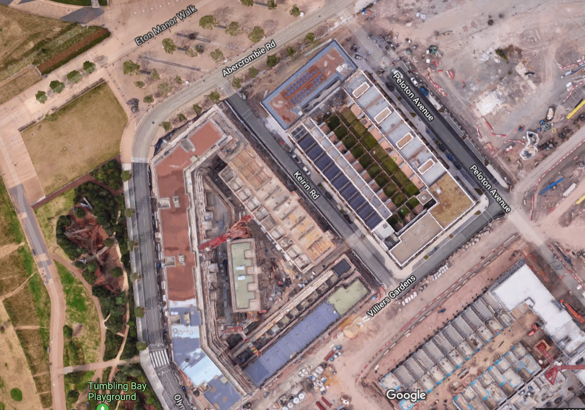
The first residents of the Olympic Park moved into their homes in the East Village at the end of 2013, following over a year of it being converted from the Athletes village. Construction of the next phase of the residential development of the park, Chobham Manor, began in 2015. Located directly opposite the East Village, where the Basketball Arena and Athletes dining hall were in 2012, 75% of the homes in Chobham Manor will be designed for families with large townhouses, private gardens and green squares a dominant feature. The first three streets, Kieren Road and Peloton Avenue, linked by Villiers Gardens, opened in 2016

Google maps satellite view shows the recently opened streets as they were last year, accessible by motor traffic but not possible to use any of them as a through route
Peloton Avenue shortly after it opened in 2016
Unfortunately at the end of last year Peloton Avenue was extended south to link up with Honour Lea Avenue and it was a real shame to see the road was not 'filtered' so motor traffic could not use it as a through route.

The same spot as above this year, now with painted cycle lanes added
Peloton Avenue, running north to south through the western end of Chobham Manor, despite Chobham Manor already being surrounded by through roads on all four sides. A couple of bollards at the junction of Villiers Gardens would have ensured the new family homes could all still be accessible by motor vehicles but only people walking or cycling could use them as through routes, leading to a safer and quieter neighbourhood
A residential road through a new development in Delft in the Netherlands, motor vehicles can access every home but not use it as a through route, as it is filtered outside a childrens play area halfway long
A photo of the bottom section of Peloton Avenue, taken through the fence late last year

The same location this year, with painted cycle lanes which "END" shortly before Honour Lea Avenue
The painted cycle lanes are not very good at all, not wide enough to ride side by side in them, they are also located in the door zone of the car parking, with cars having to drive over them to park.


 A better layout would have been to simply close the road to through traffic instead

Families can now safely cycle through residential roads in De Beauvoir Town, recently closed to through traffic by Hackney Council. A shame Peloton Avenue was not designed like this from the start
At the southern end of the Peloton Avenue is Honour Lea Avenue, pictured below in 2012, weeks before the Olympic games, taken from google street view


and here was the same spot as above in 2014, with a new bidirectional cycle track built alongside it


Whilst this cycle track was a welcome feature of the newly reconstructed road it does not connect well at either end, becoming a shared footway and difficult to access from the park on the western end of the road. The cycle track is also only 2 metres wide, which would just about be adequate if it was intended to be used in only one direction but a bidirectional cycle track should ideally be twice the width of this


People cycling on this track in opposite directions can pass each other in single file but that isn't possible if people are riding side by side, as many friends will want to do, or parents with their children


Last year a cyclists dismount sign appeared on the track


For the construction of a new road, initially for works access but eventually to become Madison Way, linking Villiers Gardens with Honour Lea Avenue.


This new road cut through the track, with kerbs and tactile paving laid across the cycle track


Thankfully the workmen have recently returned, removed the kerbs and paving and the cycle track is now continuous across the junction, although a shame the footway isn't.


Give Way signage has been added to the road for traffic exiting Chobham Manor onto Honour Lea Avenue but for motor traffic entering Chobham Manor that is not the case, just a freestanding plastic "cyclists have priority" sign


With the same happening on Peloton avenue


Which can, and does, blow over in the wind


There is a sign warning drivers of cyclists on Honour Lea Avenue but it still isn't clear that this is for those turning left, certainly not as clear as the equivalent Dutch sign I've seen many times whilst cycling in the Netherlands


These signs also recently been installed on the exits of  the four closes on the other side of Honour Lea Avenue, warning people exiting to beware of cyclists, despite the fact that the cycle track runs on the opposite side of the carriageway. This is because Honour Lea Avenue will soon form part of Quietway 6 and bizarrely the budget will go on painted Q signs on the main carriageway, rather than upgrading the existing cycle track:

"Applying the LCDS levels of service street type matrix categorises Honour Lea Avenue into the local street category which does not require segregation. The existing two way track does not connect to cycle infrastructure at either end of it. Using the link for the quietway would restrict local access for the route therefore a preference for keeping the quietway on street has been agreed by Newham Council, TFL and Sustrans" 

This is despite the fact that Honour Lea Avenue is far from quiet, every time I have been here there is a high volume of traffic, including many lorries and vans. It absolutely is a main road and will only get busier over time. Note that this "quietway" also has a 30mph speed limit

Residents exiting Chobham Manor by bike are expected to cycle over the cycle track to then cycle on the road, among lorries travelling at 30mph, or quite often, faster

I'll continue to use the cycle track and ignore the "quietway" carriageway altogether, as I suspect most families on bikes will!


One of the negative aspects of the cycle track along Honour Lea Avenue has always been that people tend to walk on it, as there really wasn't anywhere else for them to walk on this side of the road. However wide as-yet-unopened pavements have recently constructed alongside, with greenery separating them from the cycle track


The pavements are very wide here so it is just a shame that the opportunity wasn't taken to widen the cycle track at the same time


With the pavement, cycle track and door zone buffer this is almost the perfect layout - if only the cycle track wasn't so narrow and didn't give up entirely at either end!


As for Madison Way, the new road running parallel to Peleton Avenue, the footway almost immediately gives way to the entrance to substantial car parking under the apartments. I think the paved area should have continued along here to give pedestrians priority


The same applies to "Weavers Row" slightly further along


Which only leads to a dozen garages for the townhouses and also links Peleton Avenue with Madison Way

before the Olympic games the southern loop of the Eastway cycle circuit used to pass through this very point
Villiers Gardens links Peleton Avenue, Kierin Road and Madison Way. It has a large green square with seating and a small children's play area, even thought the popular tumbling bay playground is less then 100 metres away


It's nice and I like that kids can play right outside their homes; I just wish the Peleton Avenue outside was closed to through traffic so kids could play in the street alongside too!

Although at least Villiers Gardens is closed at it's western end but I think they could have designed it in a way to allow people walking and cycling through, rather than just footway and trees


There are not many people living in Chobham Manor so far but judging by the removal lorries and cardboard in the recycling bins every weekend that is soon set to change. Construction of the rest of Chobham Manor continues alongside the recently completed area. If the legacy plans are to come to fruition and this neighbourhood is filled with families then I hope improvements do come to the roads and to walking and cycling provision. The families who will grow up here and call it home deserve to have infrastructure that allows them to be able to easily walk or cycle to local schools, shopping areas and parks in perfect safety.