
The first section of this quietway begins by turning off CS2 and left onto Bancroft Road. This is not a welcoming manoeuvre to make as a much more welcoming cycle track stretches out ahead of you on Mile End Road! Every time I have cycled on Bancroft Road it has been busy, which is to be expected with the main entrance of Mile End Hospital located on it, Queen Mary University either side of it and, I suspect, people using it as a cut through from Globe Road to the A11.

I'm not sure a couple of "cycle friendly speed humps" will do much to change the environment here

The route quickly turns left into Alderney Road, where a continuous pavement is planned across the arm of the junction giving priority to pedestrians.

This is great to see but a shame more were not installed along the main road further south when CS2 was built. I'm also not sure why just this one side road gets this treatment in this scheme or even why this is part of a cycling scheme at all - why not just gradually introduce continuous pavements on every side road as part of every future road improvement scheme in Tower Hamlets?
Once into Alderney Road you're travelling West, the same direction you've just cycled from on CS2 so this doesn't exactly feel like progress. I found Alderney Road pretty busy as well with a fair amount of traffic and Mile End Hospital recommend this as a route to drive to the hospital if coming from the East, which possibly explains why. The route then continues round the North Eastern edge of Carlton Square, a very nice green area with pretty Victorian Houses along all sides of it. The plan is to create a "raised area to slow cornering vehicles" at the sharp bend at the top of the square, however from looking at the map a much better solution would be to filter the road here to create a pedestrian and cycling only section. This would also be a positive addition for pedestrians coming out of Carlton Green as well as creating quieter and safer streets for people living in the area

Continuing north along Portelet Road and it is interesting that in a ward where 66% of households have no car roughly the same amount of road space has been allocated for the parking of cars. Three "cycle friendly road humps" are to be installed along this road and my main experience of using these kind of humps is on CS1, which is mostly dreadful to cycle along. I did meet one speeding van but on the whole this street was fairly quiet and both times I cycled along here I saw someone having a driving lesson; a sure sign of low traffic! This area is naturally filtered as with the railway line to the North, the canal to the East and no way to cross either I would assume most people driving here will be either be a local resident or a visitor to the Hospital or University. I still feel a few additional "De Beauvoir Town" style filters would help create a nearly car free area and vastly improve the area for local residents.
At the end of this road Quietway 6 passes under the railway line on an already filtered road, albeit it one that is terrible to access.

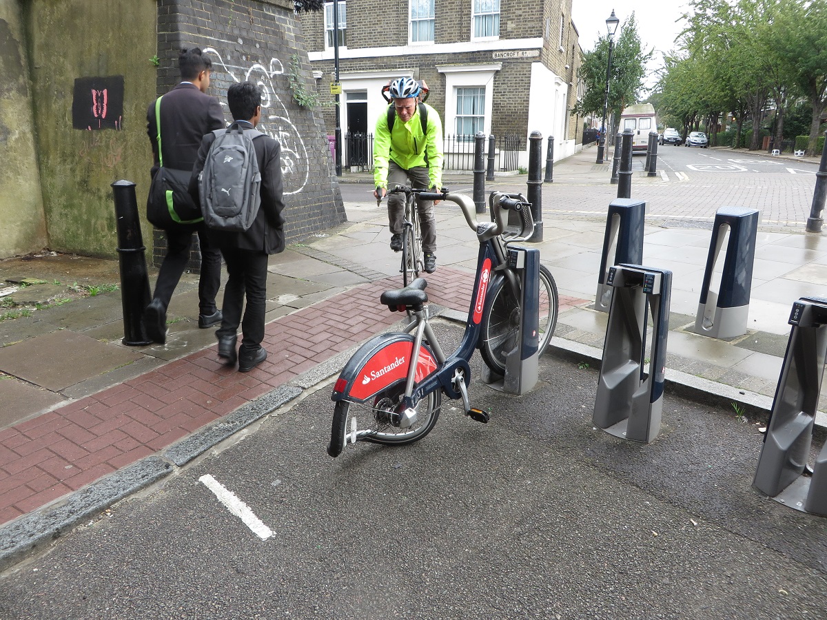
The cycle hire docking station will be moved from here and positioned onto the side of the roadway slightly to the left, so no longer any need to cycle up onto the pavement and back down again in a very tight space
If I was to suggest anything here it would be that cycles using Portelet Road and the underpass get priority over the busier Bancroft Road, or even better if the northern end of Portlet Road was closed with a Tiger Crossing leading into the underpass. The underpass itself will get "Lighting improvements and street art" along with "a contrasting surface at same level for indicative cycle track"
 |
| The recently refurbished "Dommeltunnel" bicycle tunnel in Eindhoven featuring a clear, smooth cycle track, pavement and a John Cleese Silly walks mural. Something similar here would be fantastic! |

The route then takes a zigzagged course into Meath Gardens and I had to get the map out to check which way to go. I'm sure it'll be clearer with cycle way finding signs painted on it but this route does not feel direct. In Meath Gardens itself a few quietway signs are due to be mounted onto posts, along with Shared use tiles inset into the path. Granite rumble strips are also planed to be installed to slow down cyclists but thankfully look easy enough to avoid as the ones in Hyde Park are. The path is a little narrow here - fine for locals to walk or cycle to and from the shops or work but I feel a separate cycle and walking path would be required if this became a well used cycling route, as is the case in Mile End Park nearby.

One things I am pleased to see is the two new apartment blocks either side of this path have direct access for people cycling to their homes, something I saw a lot in the Netherlands,
The route continues on a bridge over the Regents Canal, the same bridge Sadiq Khan used as a photo opportunity when he promised to make London a "byword for cycling" before he became Mayor of London. He is taking his time about it and four people have died cycling in London since he took office, so hopefully plans much bigger than this quietway will be announced soon.
I’ll make London a byword for cycling around the world - some of my plans in @cyclingweekly https://t.co/3XSR4ZzGch pic.twitter.com/wJnt20zJCK— Sadiq Khan (@SadiqKhan) December 15, 2015
As I cycled over the bridge I looked down onto the canal towpath I usually use to get home and it seemed to have taken longer to get here, having cycled an indirect 1.3km as opposed to .85km had I used the more direct route and stayed on CS2. At the bottom of the bridge the plan is to create a new path to replace the grass where the desire line is

And then routed into a "hidden" part of Mile End Park; tucked away behind the climbing wall it is not visible from the main park or canal path and so most do not know it is here. It is popular with sunbathers who want some peace and quiet but the signs warning that "Uniformed and plain clothed police officers patrol this area" makes me think this quiet and secluded part of quietway 6 is not a viable route to use after dark.
The Toucan crossing over Grove Road is to be widened from 4m to 6m but you still have to hop onto the shared use pavement and then back down onto the road, an awkward manoeuvre that risks conflict with pedestrians on the pavement. I hit the button on the Toucan crossing and waited. And waited, And waited. It was nearly a full minute until the green man appeared and I suspect many won't want to wait that long and will just cross the road on red. As I waited to cross I spotted a woman and her daughter cycling along the pavement on the opposite side of Grove Road and thought, not for the first time in this journey, how resources would be better spent on building protected space on main roads like this, rather than on quietway routes.

The route continues East along fairly attractive residential roads, although the majority of road space is, of course, given over to car parking.

The road is in a terrible condition in places so hopefully resurfacing will solve this

No new filters are planned and the one which has existed for many years is to be slightly improved by removing the two posts either side of the bollard.

basically returning it to how it was a few years ago
 |
| Image via google street view |
A shame an actual "bicycle road" isn't planned to be built here instead, similar to this scheme on Brill Place in Camden
 |
| Image via google street view |

In a narrow access road alongside the car park I was eyed suspiciously by some local youths gathered around a moped and an aggressive looking dog being taken for a final dump before bed. I don't think I'll be revisiting this section again, especially after dark.
The route then goes onto a shared footpath and then down Galahad Mews, a very narrow alleyway which doors from the block of apartments alongside open directly onto. Surely only a matter of time before someone is hit by a bike as they exit their apartment block if this scheme goes ahead.

Had you been cycling along here a few years ago then you would have been cycling through the Safeway Supermarket car park. That supermarket was demolished some time ago and the site stood empty due to various planning issues. A new Tesco supermarket did finally open here a year ago with blocks of apartments built above it and on the car park with car parking transferred into the basement. The quietway passes between the Tesco entrance and the library, sorry I mean the Bow Idea Store, next door.

You'll have to negotiate through various street furniture and shoppers to progress, probably fine if you're cycling to Tesco but this is really not suitable as a long distance cycling route. It continues round the side of Tesco into Cardigan Road

Across Roman Road and over an improved filter on Libra Road (which is apparently blocked on market days)

And then into Centurion Lane to head north along Armagh Road, a road which I know fairly well and can say with certainty that this is totally unsuitable to be called a quietway. This road is busy and there is an awful lot of car parking in the estates and houses alongside

The plan is to create a "waiting pocket" in the middle of Old Ford Road in order to cross it to access Sycamore Avenue, this is needed as it is a busy road and I found it very difficult to cross last week.
 |
| The view of the current "cycling infrastructure" in place on Old Ford Road as you cross over it |

Before we run out of quiet roads and the route uses Parnell Road and Jodrell Road, overlooking the small fact that these two roads are lorry and concrete mixer superhighways


The plan here is to paint "Large cycle logos with chevron markings, placed centrally in each lane"

This road already has large "20" signs painted centrally in each lane and these are completely ignored. Speeding is a real problem along here

This road is very busy with motor traffic all day long and I try to avoid it at all costs, as do others. This is not at all a place for those "who want to use quieter, low-traffic routes, providing an environment for those cyclists who want to travel at a more gentle pace" and no amount of centrally placed cycle chevrons will change that.
The mini roundabout on Wick Lane is "to be consulted on separately" and no changes are planned at all for Cadogan Terrace alongside Victoria Park, which should clearly be filtered, particularly as the six lane A12 runs directly alongside so would hardly be an inconvenience.

Halfway along Cadogan Terrace and you turn right as you touch the border with Hackney, to travel on the hooped bridge over the A12
 |
| Not sure how that sign could have been damaged at 20mph |
 |
| Every single building in this photo to the right of Wallis Road is either currently, or very soon will be, demolished to make way for bland apartments in the sky. Expect an awful lot of construction lorries to be using Wallis Road over the next few years. |


To cycle from CS2 to this railway bridge using the quietway route was about three miles, whereas had I travelled my usual route it would have been just under two miles. Ironically it also would have been a much quieter route along segregated cycle lanes, canal tow paths and Victoria Park and no interaction with concrete mixing lorries. Which leads me onto the question of why this quietway is being proposed at all? There are no real interventions here, it is mainly just adding signs onto some back streets. No filters or traffic reduction is planned and the roads will all stay the same as they are now, except for some reshaped speed humps. Almost every single street is too busy for children to cycle down and families won't be riding on this quietway when it is completed, just as they aren't now.
Tower Hamlets Council state on the consultation page of this quietway that:
"Quietways are a network of high quality, well signed cycle routes throughout London which run along quieter streets, parks and other off-road routes across inner and outer London. The routes will link key destinations and are designed to appeal to people new to cycling and those who already cycle who want to use quieter, low-traffic routes. Quietways will complement other cycling initiatives in London, such as the Cycle Superhighways."
Yet very little of that is true when you experience this route on a bicycle. In their cycling strategy the council commit to building segregated cycle tracks along Grove Road, linking CS2 with Victoria Park. This is exactly what is needed, along with either a later opening of Victoria Park or segregated cycle tracks on somewhere like Old Ford Road (which would need to be made one way for motor traffic to achieve this). Tower Hamlets Council should be concentrating on building networks and grids along main roads, where people want to go and building cycling routes that connect some of the already excellent routes that exist. Filtering residential roads and building continuous pavements should continue as part of a programme to create better streets for all residents with the added benefit of giving children the option of cycling from their home onto a main road nearby where cycle tracks are available.
Quietway 6 just feels like the council have been given the funding and told they must produce a quietway in their borough. A real waste of resources.
The consultation closes this Friday 30th September. Please respond here.
Thanks for this post - it pushed me into responding to the consultation.
ReplyDeleteI know the latter part of the route reasonably well, but Bancroft is a big no-no for me. Had an extremely scary punishment pass & left hook almost at the junction (southbound). Nasty road.
While the crossing "pocket" on Old Ford Road may be helpful, the council really needs to sort out Old Ford Road itself - fast, packed with traffic and parked cars. And sending people down Jodrell and Parnell as a "Quietway"! Used to commute down here in the dark - even when the HGVs aren't there it's nasty with buses and fast traffic, squeezing in between the parked vehicles. And a few sharrows are meant to fix it? Really not good enough.
As for reaching the Wick from CS2 you could — and I realise this suggestion is far from ideal — continue up CS2 to Warton or Carpenters and turn into the Olympic Park? I work on Beachy Road and have done this reasonably often in both directions. It's a bit long and the junctions are nasty, but reasonably little time with traffic.
What would it take to keep Victoria Park open into the evenings? Would it be enough just to put good lighting over the main cycle/pedestrian routes?
ReplyDeleteI think the enabling works for this route are raking place right now (august 2018) Does not look as if any changes where made as a result of the consultation?
ReplyDeleteWhatever happened to this?
ReplyDelete