
 |
| Chobham Manor and East Village |
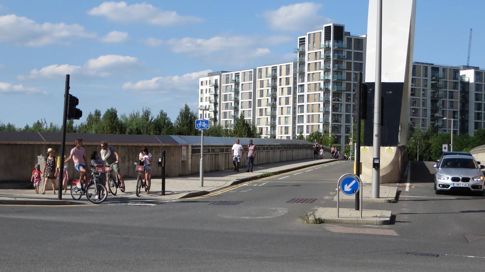
Yesterday I finished my East Wick post on the bridge on Waterden Road. To access East Village from here you will need to do a left turn onto Olympic Park Avenue. This is a manoeuvre I've had to make a few times in the past and now forward plan to avoid having to do it; instead I cross Waterden Road to go into Middlesex Way, across the bridges over the River Lea and then turn south onto Olympic Park Avenue to access East Village from there. This is a longer route but is much simpler, and crucially safer, due to this very junction. If you do have to turn left here then you have two choices; simply dart across the junction as quick as you can, crossing four lanes with no indication if the traffic lights on Westfield Avenue / Waterden Road will change to green. If this happens as you're halfway across then you're in trouble. The other option, the one the planners of this road hope you'll make, is to use the toucan crossings alongside which involves a staggered wait in the middle of the four lane Westfield Avenue (although that wait is in quite a large space) and then another wait on the other side of the road in a very small area to cross Olympic Park Avenue. This involves waiting to cross the road three times and so will usually take you at least a minute to do this.
Olympic Park Avenue begins on a bridge crossing the tracks at Stratford International station. This bridge was again built in 2009/2010, just as the ones alongside Waterden Road were, but was opened to traffic in 2011 in order for motor vehicles from the A12 to be able to access Westfield. This was known as "the lifeline" as Westfield had agreed a deal with London 2012 to create a road through the Olympic Park building site ahead of the games. Only motorists were allowed to use it and there were security guards at the entrance at all times to ensure that cyclists and pedestrians were kept out. It was a dual carriageway back then but now that Waterden Road has opened it's been downgraded to one lane in each direction with two pavements and two horrible, very narrow cycle lanes
 |
| The Olympic Park Avenue bridge in 2012, from google streetview, and in 2017 |
 |
| An example from Amsterdam |
 |
| The same spot in 2012 and 2017. Would you let your children cycle here? |
 |
| A much safer example from Utrecht, the Netherlands. |

Many don't do this and just continue to use the pavement of course
But are then left isolated and have to use the narrow toucan crossing to continue their journey. The cycle track on Olympic Park Avenue continues along the western side of the road but briefly pauses as it passes a zebra crossing into East Village (which really should be a tiger crossing but many people cycling to the shops and restaurants in East Village do just use it as well). Still, it does provide a safe space for children to ride, it is just a shame it is not continuous all the way up to Chobham Manor.
 |
| Communal barbecue spaces are located alongside here so no scorched grass. Very popular on sunny days. |

If you want to turn right from Olympic Park Avenue onto Honour Lea Avenue then you are meant to dismount, walk over the zebra crossing and then get back on your bike again.
Honour Lea Avenue runs between Chobham Manor and the East Village apartment blocks and will be the route of quietway 6. It currently has a narrow bidirectional cycle track, built in 2013/4 at the same time as the apartments in East Village were being converted from the Athletes village. It is difficult to access at either end and in my experience most people do not use it (but I always do)
 |
| A child and her mum safely use the cycle track, with the lone adult cyclist on a road bike opting for the main carriageway alongside |
Applying the LCDS levels of service street type matrix categorises Honour Lea Avenue into the local street category which does not require segregation. The existing two way track does not connect to cycle infrastructure at either end of it. Using the link for the quietway would restrict local access for the route therefore a preference for keeping the quietway on street has been agreed by Newham Council, TFL and Sustrans.
So the quietway will run along here but cyclists are expected to cycle on the road, rather than on the cycle track, despite the acknowledgement that motor traffic volumes are expected to increase here in the future. I also can't believe that this road is considered good enough to be a quietway now with no intervention, never mind in future years when the park is fully developed. Everytime I've been here there is the constant sound of motor traffic using it, quite often at high speeds, and there are no restrictions on them using it. It absolutely feels like a main road.
 |
| How comforting that Newham Council, TFL and Sustrans all agree that children can just mix with lorries on the road instead. |
Another issue with this cycle track is that it did at least used to be continuous all the way along Honour Lea Avenue (except where it turns into shared footway for a few metres half way along). With the construction of Chobham Manor came the construction of new side roads crossing it, for construction vehicles entering the site and eventually as new roads into the neighbourhood. It would have been quite simple for the cycle track and footway to continue, ensuring pedestrian and cyclist have priority, but the road was instead built through the cycle track, with kerbs and tactile paving (and "cyclists dismount" signs during construction).
 |
| Honour Lea Avenue a few years apart. This is the kind of design which kills people on bikes |
 |
| The same spot in 2012, acres of space and plenty of time to get this right |
 |
| A footway wide enough to park your car on (despite car parking along both sides of the roads and in the basements of these buildings), with room to spare |
 |
| A more sensible use of space in a new development in Delft, the Netherlands. |

I would hope the plan would be to filter many, or even all, of these roads so whilst all residents can access their homes by car (including delivery vehicles and so on) they could only be used as through routes by people walking or cycling.
 |
| An as yet unopened road with freshly laid smooth tarmac to keep motor speeds high, through the middle of Chobham Manor |
 |
| A residential road through the same new development as above in Delft, motor vehicles can access every home but not use it as a through route, as it is filtered outside a childrens play area halfway long. On the other side of the houses are cycle tracks which connect to the back of all these properties and are the most direct route both through the development and into the city centre |
 |
| Another missed opportunity here on a photo I took from the playground opposite Chobham Manor. This could be a great walking and cycling route by building a cycle track that links up with low traffic roads, creating a link right through the centre of Chobham Manor |
 |
| A cycling and walking route through a new development in Zoetermeer, the Netherlands. The entire area is cross-crossed by this type of design, with cars sent the long way round on separate routes |
@Hackneycyclist a new one for you.. The just opened 'Peleton Avenue' through Chobham Manor with velodrome just in the background pic.twitter.com/05hq5Gs5WZ
— Jon Little (@bespokejon) December 13, 2017
Back on Honour Lea Avenue and at the end of the cycle track the awful two-tier layout remains, with the cycle track becoming a shared footway and an ASL on the road alongside on quietway 6 "targeting less confident cyclists who want to use low-traffic routes" by expecting them to mix with lorries

Turn left here and a wider bidirectional cycle track resumes for a short while, before stopping again for a construction route (and presumably a permanent road) into Chobham Manor

 |
| An example of a continuous cycle track and footway, in Amsterdam |
 |
| Temple Mills Lane in 2009, with construction of the Athletes Village underway in 2009, and the widened road in the same spot in 2016, from Google Street View |
 |
| why don't some cyclists use cycle lanes? Just look at all the space that was available here for a continuous cycle track and bus stop bypass |

but once again the Google Street View car came this way in 2009 giving us a chance to see the changes between then and last year. Clearly there was the space to be able to create protected cycle tracks all along this route from the Parklands into Waltham Forest.
 |
| The same location as above in 2009, via google street view |

Understandably, a lot of children prefer to use the pavement here, rather than chance it on the road!


Liberty Bridge Road runs off Celebration Avenue. Again, it is very wide (roughly 32 metres between the buildings either side) but the majority of space is used by large footways, trees and car parking.

 |
| Not actually a parking space but gives you an illustration of how wide the footways are here |
School run in the Olympic Park @MPSOlympicPark pic.twitter.com/JK4uKZ4t2B— Hackney Cyclist (@Hackneycyclist) May 9, 2017
I was actually a bit late and the school pick up was already well under way so there were not as many cars parked along the road as there would have been ten minutes earlier but there were still a lot of cars and I happened to film an impatient parent in a BMW speeding along the pavement to dodge the queue of traffic.
The police did follow this up
In relation to an incident posted on twitter East Village police team have seized a vehicle and reported a male for dangerous driving. pic.twitter.com/pbXEO2h8g9— Olympic Park Police (@MPSOlympicPark) May 11, 2017
and in the following weeks increased their patrols in the area during school run times. I thought I would pop along this month to see how the situation was and am sad to report it was even worse than it was in my film from earlier in the year with cars parked on all the footways and on double yellow lines both on Cheering Lane and Liberty Bridge Road. There were police officers and council officials there but they did nothing to stop any of the illegal parking, I assume they were only there to stop the type of footway driving I filmed or any road rage incidents. I avoid this area most of the time but especially at school run times, it is a really unpleasant place to be as a pedestrian or cyclist.
South of Liberty Bridge Road is Mirabelle Gardens, which I've written about before and the crazy one way road which runs around the square with no exception for people cycling. I've noticed a lot of motor traffic going into it from Liberty Bridge Road and quite clear they are using it as a shortcut to get to Westfield and avoid several sets of traffic lights on Celebration Avenue instead, as they do with Cheering Lane. It should ideally be filtered to through motor traffic but difficult to do with the one way design of it.
Opposite Celebration Avenue is Victory Park and a cycle track runs along the southern edge of it, which I previously described on here as going from nowhere to nowhere. However I've since realised that it does actually make a right turn and also runs along the western edge of the park, so badly designed was it that I had failed to notice this
 |
| The cycle track with it's 90 degree right turn |

A market is held here every Sunday and unfortunately some of the stalls are always placed on the edge of this cycle track, which clearly renders it virtually useless

Back in 2014 I didn't write about the area around Victory Park as it was just a load of empty retail units and an almost always empty park. The signs on the empty retail units promising "35 new shops, cafes, restaurants, pubs and bars" seemed optimistic at the time but now all of the units are occupied with some really great choices of restaurants and shops, albeit some of them a tad on the expensive side. A couple of coffee shops which originally stared out in Hackney, the same wine shop and Fish Restaurant that can be found in Victoria Park Village, an Ice cream parlour and fruit and veg shop who both use cargo bikes parked outside to advertise, Pave Velo, a bike shop where Lee and his team will service your bike or sell you one, the list goes on. It does not feel like Stratford at all; a really nice place to relax at the weekend and will only get busier as more residential blocks are completed nearby.
"Victory Parade" runs from Olympic Park Avenue to Victory Park and I used to enjoy the deserted cycle through here a few years ago. The situation is very different these days as you now must cycle among shoppers and people sat on tables outside cafes

I personally do not see this an an issue at all and think it is great to see families slowly cycling through here

I think pedestrianised streets which allow cycling can exist perfectly well in the UK, just as they do in the Netherlands and will do on a transformed Narroway in Hackney next year

I really hope that cycling continues to be permitted along here for future generations

Using this route to cycle to East Village from the parklands or the cycle track on Olympic Park Avenue should be maintained because unfortunately, most of the surrounding roads are truly terrible to cycle on.
Next Post: Part Three - Westfield Stratford City
Previous Post: Part One - East Wick
This i a great blog. Perfectly sums up the mess that is the East Village, and the missed opportunities to make it a great place to cycle.
ReplyDelete