A few weeks ago I wrote about changes to a street in the centre of Eindhoven, where a lane for private motor traffic had been removed to create greenery and more space for people walking and cycling and vowed to post again about changes to a main road leading out of the city.
Eindhoven suffered heavy damage in the Second World War from air raids with large parts of the city destroyed, with the city planners then destroying even more of it later on. It has a very 1960s feel to some parts of it, especially the area around the train station with brutalist architecture and people walking and cycling often having to do so via long underpasses beneath main roads and railway lines.
To the north of the city centre in the district of Woensel Zuid the old buildings and roads that remained after the war were swept away for new housing estates and very wide roads, such as Veldmaarschalk Montgomerylaan (the translation of which is Field Marshall Montgomery Avenue, named after the British army officer who led the operation to liberate Eindhoven), which is the road I used as I left the city to cycle to Den Bosch back in 2016
Veldmaarschalk Montgomerylaan in 2016. It had a very dated look, with a tiled cycle track that was barely distinguishable from the footway alongside and an odd hedge in the centre as the dividing line between the northbound cycle track and southbound track
The same spot in 2020 with a modern upgrade. The cycleway now has smooth asphalt and has centre markings, meaning the full width of the track can be used. The footway has also been repaved and is much brighter, with forgiving kerbs at the edge of the cycle track.
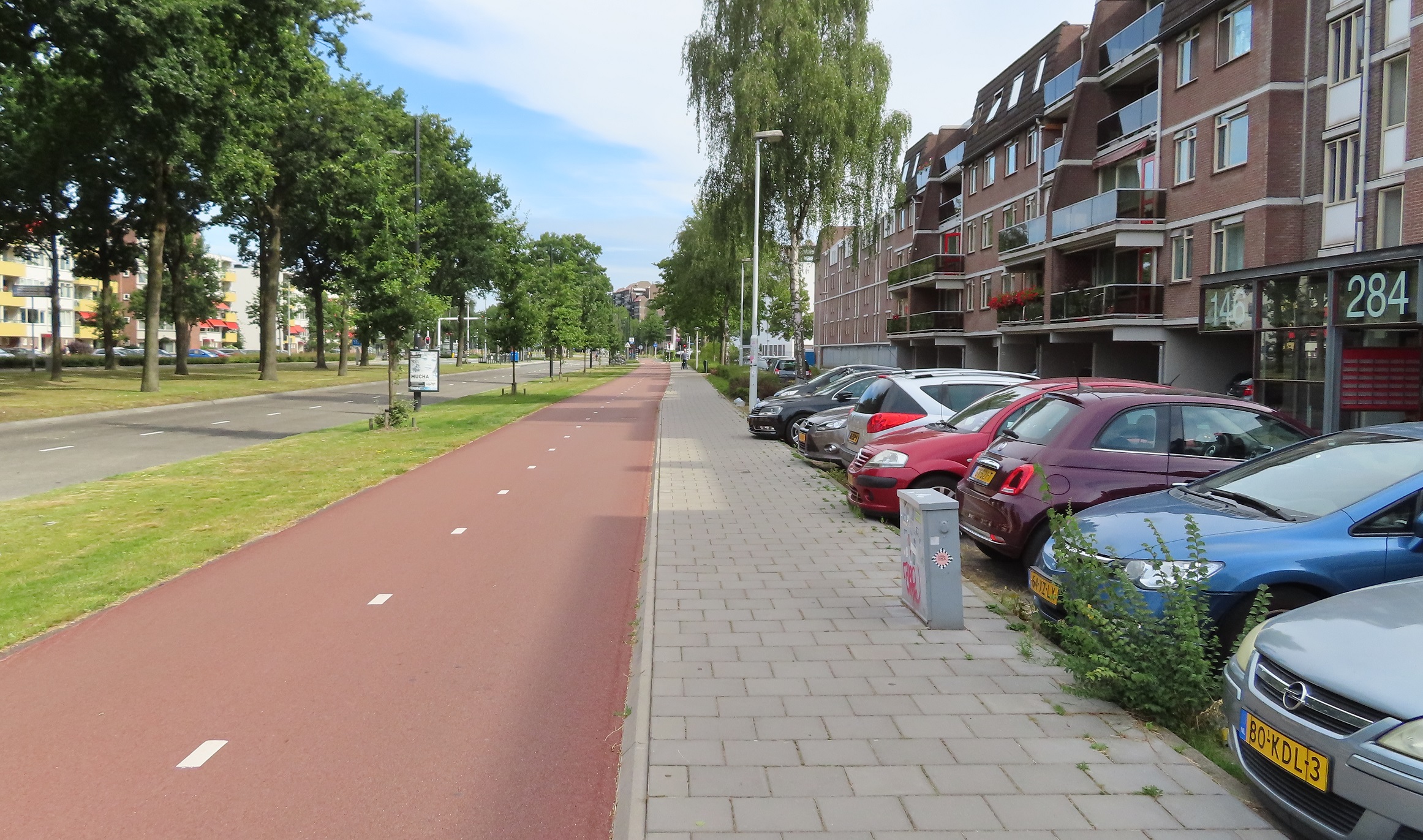
Slightly further north along the same road in 2016
The same location in 2020. The tree in the middle of the cycle track has been cut down to allow a bidirectional cycle track with no barrier, but many new trees have been planted between the cycle track and the road, which will grow to provide shelter from rain, sun and also from the noise of the roadway alongside.
However, this was not just an upgrade of the cycle track, this was a major transformation of a road built in the second half of the 20th Century from one designed to carry a large amount of private motor vehicles into the city centre, into one which instead prioritises public transport.
This is the southbound carriageway of the road taken from Google streetview a decade ago. It shows the post war layout that had been here for decades; a very wide road with multiple lanes for motor traffic in both directions and a very wide central reservation between them
The same spot on the most recent streetview capture. What was the southbound carriageway has now been reconfigured to carry traffic in both directions. Along most of this road motor traffic now just has a single lane in each direction; it is only at the junctions that additional lanes appear for motor traffic to turn off the road
This was the northbound carriageway a decade ago, a minimum of two lanes for motor traffic at all times, gaining up to five lanes at the junctions, now motor traffic just has a single lane on the other side of the central reservation
The same location as above in 2020. What was the northbound carriageway is now a dedicated bus only expressway, giving buses a clear route into the city centre and no longer being delayed by motor traffic, along with the added bonus of an upgraded cycleway alongside
The new bus expressway only allows buses to use it, so unlike in London there is no sharing with taxi's or motorbikes (who use the adjacent roadway) or bicycles (who have a dedicated cycleway alongside) so the bus drivers can drive here with no interactions with other traffic or any delays. Although of course this bus expressway can also be used by emergency services giving them a clear route to quickly attended any incidents and improving response times. Here is a video of the bus expressway in use:
There are regular crossing points for people walking and cycling and these are placed on the desire lines, usually alongside the bus stops, which are also located next to junctions giving pedestrians who have either alighted or are going to catch a bus a crossing right alongside the bus stop, and people cycling east to west across the road, or turning off the cycleway to turn left, a crossing where they need it to be.
One thing I noticed is that these crossings were quite often default green but when a bus approached they always remained red and an audio warning sounded, along with a flashing bus icon to warn people not to cross. This results in buses not being delayed at crossings and reduces the possibility of a collision between a bus and anyone walking or cycling
At each bus stop there was always plenty of cycle parking, allowing people to cycle to the bus stop to catch the bus, and then cycle home afterwards when they return
Back in 2016 as I cycled along here the road expanded out to four lanes as it approached the ring road
Now, it is just a two lane bus expressway with new trees between the upgraded cycle track and the bus lanes
Although I didn't notice this as I cycled through here last month, the ring road has also been buried in an underpass under the road, with additional bidirectional cycle tracks created on all sides of the junction. The image below shows the changes from Google Earth satellite imagery (with the new layout still not fully complete)
Once again I couldn't help notice as I approached the junctions that the buses always seemed to have a green light as they approached, with all cars and cycles receiving a red light. The new layout really does put people on public transport first and creates a fast bus expressway that is not being delayed on its journey in any way, except when passengers board or alight.
This new layout continued all the way up Veldmaarschalk Montgomerylaan for another two miles, giving me a comfortable safe cycle route alongside the buses which sped past me every few minutes. I then came to a road named Winston Churchilllaan (I told you these were post war roads!). Once again the same layout continued along here east out through the suburbs, with a check of google streetview showing that the same upgrade had been implemented; a wide multi lane dual carriageway for motor traffic replaced by a bus expressway with just a single lane for motors
The same road two decades apart from streetview; a dual carriageway with cycleways either side to a single lane for motor traffic, a bus only road, along with upgraded cycle tracks
After another couple of miles the residential buidings alongisde gave way to fields as I exited Eindhoven but the bus expressway continued (although the bus lanes split and crossed over here to run either side of the road). Again I was surprised to check goggle streetview to see that what was a rural dual carriageway had also been reconfigured and reduced to a single lane to allow a fast bus route from Eindhoven out to neighbouring towns.
Google Earth satellite imagary shows the road leading east out of Eindhoven through fields to the town of Nuenen in 2009, a dual carriageway with cycle paths either side of it
The same road a decade later. There is now just a single lane for motor traffic in either direction. Separate from that road are bus lanes either side, allowing buses to get from Nuenen directly to the centre of Eindhoven without any delays. The cycle tracks either side have also been upgraded and widened - now with red asphalt and centre markings to show they are both bidirectional
As I cycled between Eindhoven and Nuenen I did so behind a family; a mum with her young daughter of primary school age alongside and her not much older son up ahead of them, safely cycling alongside a rural main road in perfect safety
I cycled behind them for a couple of miles; obviously I don't where they had been cycling from but assuming they were cycling from the centre of Eindhoven to Nuenen then they would have cycled just over seven kilometres or nearly five miles, which is perfectly normal for Dutch families. Now nobody is forcing them to do this of course but the safe and direct cycleway gives them this option. They could have taken the bus, which probably would have been quicker and would have not been delayed at any junction or by any other motor traffic due to the new fast expressway. They would have used an OV-chipkaart for this journey, which is a travel card that allows entry onto any bus, tram or train in the entire country. It also allows access to underground bike parking facilities at train stations and use of the OV-fiets bicycle hire.
Eindhoven has a population of roughly 220,000 so about the same as a British city such as Reading, Luton or Wolverhampton. Imagine a mother and her two young children making a journey to and from a town five miles away from those cities. The bus would be expensive, have an irregular timetable and almost certainly held up by other motor traffic. I can't envisage any of these cities getting rid of a dual carriageway anytime soon! As for a family like this cycling on a main A road or dual carriageway in the UK? Well, it might be legal but it would almost certainly not happen as it would be incredibly dangerous thing to do with no separate cycling infrastructure and motor traffic moving at very high speeds. The default option in the UK would be to drive, with little incentive to use any alternative mode of transport.
Whilst I mostly concentrate on writing about Dutch cycling schemes on here it is worth remembering that the Dutch are also vastly improving their bus, metro and train services, whilst also improving cycling and walking conditions. Many councils have declared a climate emergency but I don't see any reallocating space on their roads like the Dutch are to help achieve this.
"the Dutch are also vastly improving their bus, metro and train services"
Eindhoven has done well to build this network of busways over the years, but let's not exaggerate. Only a handful of major public transport schemes have gone ahead this century, many of them being widely criticised for project mismanagement, budget overruns and some negative effects on the network. This seems to have emboldened certain politicians to agitate against such schemes, with several having been cancelled throughout the same period. Many regional concessions still do not allow for growth, ten years after the cuts during the economic crisis, so any growth in one route must be matched with a cut elsewhere. Meanwhile, although it has slowed down, a fortune has been spent on widening motorways etc.
Fortunately, many places indeed still invest in cycling. Even if my own Breda doesn't seem so bothered ;)
Great post, interesting to see the development in recent years. My cycle route to work was already a good cycle path, but it was still resurfaced this year. Nice place to live and feel no need to own a car since moving over from england.


"the Dutch are also vastly improving their bus, metro and train services"
ReplyDeleteEindhoven has done well to build this network of busways over the years, but let's not exaggerate. Only a handful of major public transport schemes have gone ahead this century, many of them being widely criticised for project mismanagement, budget overruns and some negative effects on the network. This seems to have emboldened certain politicians to agitate against such schemes, with several having been cancelled throughout the same period. Many regional concessions still do not allow for growth, ten years after the cuts during the economic crisis, so any growth in one route must be matched with a cut elsewhere. Meanwhile, although it has slowed down, a fortune has been spent on widening motorways etc.
Fortunately, many places indeed still invest in cycling. Even if my own Breda doesn't seem so bothered ;)
Great post, interesting to see the development in recent years. My cycle route to work was already a good cycle path, but it was still resurfaced this year. Nice place to live and feel no need to own a car since moving over from england.
ReplyDelete